
Amazonas State is one of the 23 states into which Venezuela is divided. It covers nearly a fifth of the area of Venezuela, but has less than 1% of Venezuela's population.
Parima Tapirapecó National Park is a Venezuelan national park in the southern state of Amazonas.

Pico da Neblina National Park is a national park in the state of Amazonas in the north of Brazil, bordering on Venezuela. It overlaps with several indigenous territories, which creates tensions over land use, as does the military presence due to the border location. The park includes lowlands around the Rio Negro, partly flooded, and mountains that include the highest peak in Brazil, after which the park is named. The wide variety of physical environments supports great biodiversity, including several endangered species.
Anomaloglossus tamacuarensis is a species of frog in the family Aromobatidae. It is found in the Sierra Tapirapecó in the Amazonas state of Venezuela as well as in the adjacent Amazonas state of Brazil.
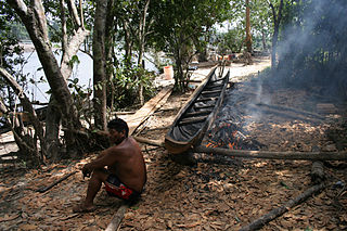
The Ye'kuana, also called Ye'kwana, Ye'Kuana, Yekuana, Yequana, Yecuana, Dekuana, Maquiritare, Makiritare, So'to or Maiongong, are a Cariban-speaking tropical rain-forest tribe who live in the Caura River and Orinoco River regions of Venezuela in Bolivar State and Amazonas State. In Brazil, they inhabit the northeast of Roraima State. In Venezuela, the Ye'kuana live alongside their former enemies, the Sanumá.

Duida–Marahuaca National Park is a protected area in Amazonas state, Venezuela. It has an area of 210,000 ha, and includes the Duida–Marahuaca Massif.
The Serranía de la Neblina National Park is a national park of Venezuela.

The Guianan savanna (NT0707) is an ecoregion in the south of Venezuela, Guyana and Suriname and the north of Brazil. It is in the Amazon biome. The savanna covers an area of rolling upland plains on the Guiana Shield between the Amazon and Orinoco basins. It includes forested areas, but these are shrinking steadily due to the effect of frequent fires, either accidental or deliberate. The ecoregion includes the Gran Sabana region of Venezuela.

The Negro–Branco moist forests (NT0143) is an ecoregion of tropical moist broadleaf forest to the east of the Andes in southern Venezuela, eastern Colombia and northern Brazil, in the Amazon biome. It lies on the watershed between the Orinoco and Rio Negro basins. It includes both blackwater and whitewater rivers, creating different types of seasonally flooded forest. The vegetation is more typical of the Guiana region than the Amazon.

The Japurá–Solimões–Negro moist forests (NT0132) is an ecoregion of tropical moist broad leaf forest in the Amazon biome.

The Madeira-Tapajós moist forests (NT0135) is an ecoregion in the Amazon basin. It is part of the Amazon biome. The ecoregion extends southwest from the Amazon River between its large Madeira and Tapajós tributaries, and crosses the border into Bolivia. In the south it transitions into the cerrado biome of Mato Grosso. In the state of Rondônia it contains some of the most degraded land of the Amazon basin.

The Xingu–Tocantins–Araguaia moist forests (NT0180) is an ecoregion in the eastern Amazon basin. It is part of the Amazon biome. The ecoregion is one of the most severely degraded of the Amazon region, suffering from large-scale deforestation and selective extraction of timber, particularly along the Trans-Amazonian Highway and in the higher and more populated southern portions.

The Tocantins–Araguaia–Maranhão moist forests (NT0170), also called the Tocantins/Pindaré moist forests, is an ecoregion in the north of Brazil to the south of the mouth of the Amazon River. It is part of the Amazon biome. The ecoregion contains the city of Belém, capital of the state of Pará. It is the most developed part of the Amazon region, and is one of the most severely degraded natural habitats of the region.

The Solimões-Japurá moist forests (NT0163) is an ecoregion in northwest Brazil and eastern Peru and Colombia in the Amazon biome. It has a hot climate with high rainfall throughout the year, and holds one of the most diverse collections of fauna and flora in the world. The ecoregion is relatively intact.

The Juruá–Purus moist forests (NT0133) is an ecoregion in northwest Brazil in the Amazon biome. The terrain is very flat and soils are poor. The rivers flood annually. There are no roads in the region, and the dense rainforest is relatively intact, although plans to extend the Trans-Amazonian Highway through the region would presumably cause widespread damage to the habitat.
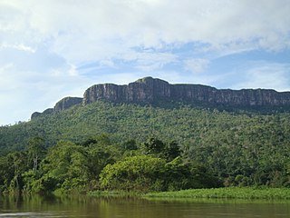
The Guayanan Highlands moist forests (NT0124) is an ecoregion in the south of Venezuela and the north of Brazil and in Guyana, Suriname, French Guiana. It is in the Amazon biome. It encompasses an upland region with diverse fauna and flora, which contains dramatic tepuis, or sandstone table mountains. The region has been inaccessible in the past and is generally fairly intact, apart from the north and northeast where large scale agriculture, ranching and mining operations are steadily encroaching on the ecosystem. New roads are opening the interior to logging, and planned dams will have a drastic impact on the riparian zones.

The Guianan moist forests (NT0125) is an ecoregion in the east of Venezuela, north of Brazil and the Guyanas. It is in the Amazon biome. The climate is hot and humid, with two rainy seasons each year. As of 1996 the tropical rainforest habitat was relatively intact, although there were mounting threats from illegal logging and gold mining.

The Amazon–Orinoco–Southern Caribbean mangroves (NT1401) is an ecoregion along the coasts of Colombia, Venezuela, Guyana, Suriname, French Guiana and Brazil.

The Orinoco Delta swamp forests (NT0147) is an ecoregion of eastern Venezuela and northern Guyana covering the large and shifting Orinoco Delta. The vegetation is mostly permanently flooded rainforest. The ecoregion is relatively intact apart from a large area that was damaged by a failed flood control program in the 1960s. It is inaccessible, so logging is difficult, and the soil is unsuitable for farming. The main threat comes from oil exploration, which would bring an influx of settlers into the delta.

The Napo moist forests (NT0142) is an ecoregion in the western Amazon rainforest of Colombia, Ecuador and Peru.
