Alto Lucero is a city and municipality in the Mexican state of Veracruz. It is located at 19°37′N96°44′W, some 35 km from state capital Xalapa. The Laguna Verde nuclear power plant, Mexico's only such facility, was built near the town of Punta Limón in Alto Lucero municipality during the 1970s.

Água Comprida is a Brazilian municipality located in the west of the state of Minas Gerais. Its population as of 2020 was estimated to be 1,992 people living in a total area of 489 km2. The city belongs to the mesoregion of Triângulo Mineiro and Alto Paranaíba and to the micro-region of Uberaba. It became a municipality in 1953.

The Province de la Kossi lies in the western part of Burkina Faso and stretches to the border with Mali. It is in the Boucle du Mouhoun Region. The capital of Kossi is the town of Nouna, which has a mayor and high commissioner. The next largest town in Kossi is Djibasso, the last major town on the road from Nouna that heads west into Mali.

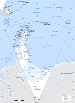
Argentine Antarctica is an area on Antarctica claimed by Argentina as part of its national territory. It consists of the Antarctic Peninsula and a triangular section extending to the South Pole, delimited by the 25° West and 74° West meridians and the 60° South parallel. This region overlaps with British and Chilean claims in Antarctica. None of these claims have widespread international recognition.

Jacaltenango is a town and municipality situated in the Western Highlands of Guatemala. It is located in a valley surrounded by the Sierra Madre Mountains. Jacaltenango serves as the municipal seat for the surrounding municipality of the same name. In 2002, its urban population was about 23,500 but at the 2018 census the town's population has decreased to 22,533.

Siuna is a county-sized administrative municipality in Nicaragua, located approximately 318 kilometres (198 mi) northeast of the capital city of Managua and 218 kilometres (135 mi) west of the coastal city and regional capital Puerto Cabezas in the North Caribbean Autonomous Region (RACN). Siuna is the name of the city as well as the municipality. The municipality of Siuna contains 204 rural communities and 20 neighborhoods. Most were settled in support of gold mining along the Ei River drainage basin, leading to rapid population growth from the mid-1930s.

Pedro Domingo Murillo is a province in the Bolivian La Paz Department. It was created on January 8, 1838, with the name Cercado and on October 17, 1912, during the presidency of Eliodoro Villazón, its name was changed in honor of Pedro Domingo Murillo, protagonist of the revolution of June 16, 1809.

The Chiapas Highlands, also known as the Central Highlands of Chiapas or Chiapas Plateau, is a geographic, sociocultural and administrative region located in Chiapas, the southernmost state of Mexico.

Coroico is a town in Nor Yungas Province, in the La Paz Department of western Bolivia.

Montoro is a municipality of Spain belonging to the province of Córdoba, Andalusia. Housing lies on a bend of the river Guadalquivir, which envelopes from West, North, and East.

Adolfo Alsina is a western partido of the Buenos Aires Province, Argentina, found at coordinates 37°10′S62°44′W.

Conquista de la Sierra is a municipality located in the province of Cáceres, Extremadura, Spain. According to the 2006 census (INE), the municipality has a population of 220 inhabitants.

Mora de Rubielos is a municipality located in the mountainous area of the Iberian System, province of Teruel, Aragon, Spain.

Miary is a rural municipality in Madagascar. It belongs to the district of Toliara II, which is a part of Atsimo-Andrefana Region. The population of the municipality was estimated to be approximately 12500 in 2008 of which 90% are Masikoro. The municipality has 11 fokontany (villages).
Anosivelo is a rural municipality in Madagascar. It belongs to the district of Farafangana, which is a part of Atsimo-Atsinanana Region. The population of the commune was estimated to be approximately 17,000 in 2001 commune census.

Concepción is a town in the lowlands of eastern Bolivia. It is known as part of the Jesuit Missions of Chiquitos, declared in 1990 a World Heritage Site, as a former Jesuit Reduction.

The Montes de Toledo is one of the main systems of mountain ranges in the Iberian Peninsula. They divide the drainage basin of the Tagus from the basin of the Guadiana. The highest peak is La Villuerca, which is 1,603 m (5,259 ft) high.

Gúdar-Javalambre is a comarca in Aragon, Spain. The most important town is Mora de Rubielos.
Toualet is a small town and rural commune in Settat Province of the Chaouia-Ouardigha region of Morocco. At the time of the 2004 census, the commune had a total population of 11815 people living in 1708 households.


