
Rhineland-Palatinate is a western state of Germany. It covers 19,846 km2 (7,663 sq mi) and has about 4.05 million residents. It is the ninth largest and sixth most populous of the sixteen states. Mainz is the capital and largest city. Other cities are Ludwigshafen am Rhein, Koblenz, Trier, Kaiserslautern, Worms, and Neuwied. It is bordered by North Rhine-Westphalia, Saarland, Baden-Württemberg and Hesse and by France, Luxembourg and Belgium.

The Saalburg is a Roman fort located on the main ridge of the Taunus, northwest of Bad Homburg, Hesse, Germany. It is a cohort fort, part of the Limes Germanicus, the Roman linear border fortification of the German provinces. The Saalburg, located just off the main road roughly halfway between Bad Homburg and Wehrheim is the most completely reconstructed Roman fort in Germany. Since 2005, as part of the Upper Limes, it forms part of a UNESCO World Heritage site. In the modern numbering system for the limes, it is ORL 11.

Birkenheide is a municipality in the Rhein-Pfalz-Kreis, in Rhineland-Palatinate, Germany and is part of the Verbandsgemeinde Maxdorf.

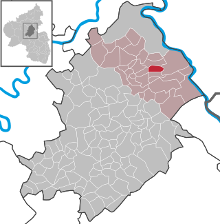
Kronweiler is an Ortsgemeinde – a municipality belonging to a Verbandsgemeinde, a kind of collective municipality – in the Birkenfeld district in Rhineland-Palatinate, Germany. It belongs to the Verbandsgemeinde of Birkenfeld, whose seat is in the like-named town.
Utzenhain is an Ortsgemeinde – a municipality belonging to a Verbandsgemeinde, a kind of collective municipality – in the Rhein-Hunsrück-Kreis (district) in Rhineland-Palatinate, Germany. It belongs to the Verbandsgemeinde Hunsrück-Mittelrhein, whose seat is in Emmelshausen.
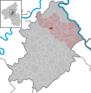
Thörlingen is an Ortsgemeinde – a municipality belonging to a Verbandsgemeinde, a kind of collective municipality – in the Rhein-Hunsrück-Kreis (district) in Rhineland-Palatinate, Germany. It belongs to the Verbandsgemeinde Hunsrück-Mittelrhein, whose seat is in Emmelshausen.

Lindenschied is an Ortsgemeinde – a municipality belonging to a Verbandsgemeinde, a kind of collective municipality – in the Rhein-Hunsrück-Kreis (district) in Rhineland-Palatinate, Germany. It belongs to the Verbandsgemeinde of Kirchberg, whose seat is in the like-named town.

The Deutsche Staatsphilharmonie Rheinland-Pfalz is a German orchestra based in the German state of Rhineland-Palatinate, in Ludwigshafen am Rhein.. as of the 2015/2016 season.
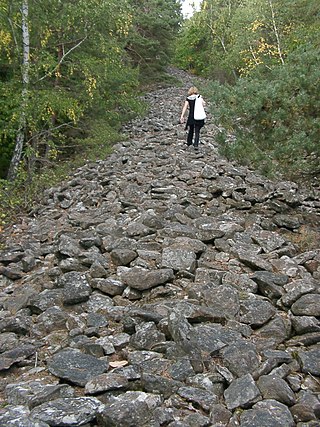
The Heidenmauer near the Palatine county town of Bad Dürkheim in the German state of Rhineland-Palatinate is a circular rampart or ringwork, two and a half kilometres long, which was built by the Celts around 500 B. C. as a type of Murus Gallicus but was pulled down again not long afterwards. The wooden elements of the wall have disappeared over the course of time by rotting away, but the stones have survived.

The Upper Germanic-Rhaetian Limes, or ORL, is a 550-kilometre-long section of the former external frontier of the Roman Empire between the rivers Rhine and Danube. It runs from Rheinbrohl to Eining on the Danube. The Upper Germanic-Rhaetian Limes is an archaeological site and, since 2005, a UNESCO World Heritage Site. Together with the Lower Germanic Limes it forms part of the Limes Germanicus.

The Roman fort at Weissenburg, called Biriciana in ancient times, is a former Roman ala castellum, which is a UNESCO World Heritage Site located near the Upper Germanic-Rhaetian Limes. It lies in the borough of Weißenburg in the Middle Franconian county of Weißenburg-Gunzenhausen in Germany. Today the castellum is one of the most important sites of research in the Roman limes in Germany. The site contains partly subterranean building remains, a reconstructed north gateway, large thermal baths and a Roman Museum with an integrated Limes Information Centre.

The Lower Germanic Limes is the former frontier between the Roman province of Germania Inferior and Germania Magna. The Lower Germanic Limes separated that part of the Rhineland left of the Rhine as well as the southern part of the Netherlands, which was part of the Roman Empire, from the less tightly controlled regions east of the Rhine.

The Neckar-Odenwald Limes is a collective term for two, very different early sections of the Upper Germanic-Rhaetian Limes, a Roman defensive frontier line that may have been utilised during slightly different periods in history. The Neckar-Odenwald Limes consists of the northern Odenwald Limes (Odenwaldlimes), a cross-country limes with camps, watchtowers and palisades, which linked the River Main with the Neckar, and the adjoining southern Neckar Limes (Neckarlimes), which in earlier research was seen as a typical 'riverine limes', whereby the river replaced the function of the palisade as an approach obstacle. More recent research has thrown a different light on this way of viewing things that means may have to be relativized in future. The resulting research is ongoing.
Pfünz Roman Fort, Castra Vetoniana or Vetonianae, was a Roman cohort camp near Pfünz, a village in the municipality of Walting in the county of Eichstätt, Bavaria. It was built in about 90 A. D. on a 42-metre-high Jurassic hillspur between the valley of the Altmühl and that of the Pfünzer Bach stream. it is a component of the Rhaetian Limes which was elevated in 2005 to the status of a UNESCO World Heritage Site. Of historical importance are the remains of the double V-shaped ditches hewn out of the rock in front of the position, the one on the western rampart being the best preserved. In 1998, as part of the construction of a high pressure water system, the Bavarian State Office for Monument Protection carried out further test excavations. The archaeological record and rich finds from Pfünz, some of which are very rare, are seen as reasons for further studies in the future.

Wörth (Rhein) station—originally Wörth (Pfalz)—is the most important station of the town of Wörth am Rhein in the German state of Rhineland-Palatinate. Deutsche Bahn classifies it as a category 5 station and it has five platforms. The station is located in the area of the Karlsruher Verkehrsverbund and it belongs to fare zone 540. Since 2001, Verkehrsverbund Rhein-Neckar (VRN) tickets are also accepted for travel to or from the VRN area. The address of the station is Bahnhofstraße 44.
The Main Limes, also called the Nasser Limes, was built around 90 AD and, as part of the Upper Germanic-Rhaetian Limes, formed the frontier of the Roman Empire in the area between the present day villages of Großkrotzenburg and Bürgstadt. In this section the limes adjoined the River Main (Moenus), which forms a natural boundary for about 50 kilometres here, so "Main" refers to the river.
The Danube–Iller–Rhine Limes or DIRL was a large-scale defensive system of the Roman Empire that was built after the project for the Upper Germanic-Rhaetian Limes in the late 3rd century AD. In a narrower sense the term refers only to the fortifications between Lake Constance and the River Danube (Danubius); in a broader sense it also includes the other Late Roman fortifications along the river Rhine (Rhenus) on the High Rhine and on the Upper Rhine as well as the Upper Danube.
Magnus Backes was a German art historian and historic preservationist. From 1983 to 1991, he succeeded Werner Bornheim gen. Schilling and Hartmut Hofrichter as the third Landeskonservator of the General Directorate for Cultural Heritage Rhineland-Palatinate Rheinland-Pfalz in Mainz.
The village of Gönnersdorf, Rhineland-Palatinate, Germany, extends on the hills north of the Rhine above the village of Fahr, which lies directly on the river. Gönnersdorf as well as Fahr are today part of the locality of Feldkirchen, itself incorporated into the town of Neuwied.


