Aschaffenburg is a town in northwest Bavaria, Germany. The town of Aschaffenburg is not part of the district of Aschaffenburg, but is its administrative seat.

Gustav Otto was a German aircraft and aircraft engine designer and manufacturer.

Milbertshofen, Am Riesenfeld and Am Hart are three boroughs situated in the north of Munich in Germany. Jointly, they form the city district 11 Milbertshofen-Am Hart. As of December 2016, the three boroughs had 76.255 inhabitants.

Gustav Otto Flugmaschinenfabrik was a pioneering German aircraft producer during the early part of the 20th century. Founded in 1910 by Gustav Otto in Bavaria, the firm was reorganized on 7 March 1916 into Bayerische Flugzeugwerke (BFW). In 1917, a Bavarian aircraft engine maker called Rapp Motorenwerke changed its name to Bayerische Motoren Werke GmbH (BMW). That company transferred its engine-production assets and the BMW name in 1922 to Bayerische Flugzeugwerke, which was then renamed to Bayerische Motoren Werke AG and subsequently evolved into the automotive manufacturer that is now known as BMW.

Schleißheimer Straße is the second longest street in Munich after Dachauer Straße with a length of 8.14 km. It starts in the city centre at Stiglmaierplatz, leads through five districts and ends at Goldschmiedplatz. It takes its name from the northern suburb of Oberschleißheim, where it originally ended.

Feldmoching-Hasenbergl is a borough in the northern part of the city of Munich in Bavaria, Germany. It contains the S-Bahn railway station of München-Feldmoching.
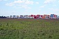
The Panzerwiese is a 200 hectare heath area in Milbertshofen-Am Hart in the north of Munich, Germany.

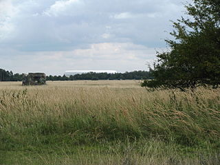
Hartelholz is a 115-hectare (280-acre) forest in the north of Munich, Germany.

Am Riesenfeld is the westernmost of the three subdistricts of the Munich city district 11 Milbertshofen-Am Hart.
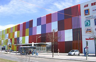
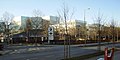
The Mira is a district and shopping center that opened in 2008 in the Munich district Nordhaide at Schleißheimer Straße which borders the municipalities of Milbertshofen-Am Hart and Feldmoching-Hasenbergl.
The Lerchenauer Straße is a 5.5 km long arterial road in Munich.

The Ingolstädter Straße in the Munich district of Milbertshofen-Am Hart and Schwabing-Freimann is a 4 kilometer long exit road heading North, where it connects there with Leopoldstraße.

The Stammstrecke 2 of the Munich U-Bahn is one of three main routes in the subway network of the Bavarian capital Munich. It runs from north to south, as well as east, and is currently operated by the underground U1 and U2 lines. Since 12 December 2011, the U7 line runs during high traffic times and since 15 December 2013 the U8 line assists on Saturdays. The U1 and U2 lines only run together on one route, in the central inner city area, before and after that, they are branched away from each other. The main line 2 has a total length of 33.8 kilometers and 38 underground stations. It runs exclusively in the city of Munich and completely in the tunnel.
The Schwere-Reiter-Straße is a 1.2 km long street in Munich's Schwabing-West district in the Oberwiesenfeld area. It leads from Leonrodplatz to the Hohenzollernstraße on the corner of Winzererstraße, where it branches off to the north of the Ackermannstraße.

Neuhauser Straße is part of the first and largest pedestrian zone in Munich's Old Town. Here, many retail shops and restaurants are to be found.

The Munich Old Town is part of the Bavarian capital Munich and has belonged to the city the longest, even if some places which are meanwhile districts of Munich, were mentioned long before Munich's documents spoke of the Old Town. The Old Town forms together with the district Lehel, the municipality No. 1 Altstadt-Lehel. The entire area of the Old Town is listed as both a historical ensemble as well as a historical monument listed in the Bavarian historical monument list.

Alter St.-Georgs-Platz is a square in Munich's Milbertshofen-Am Hart district.

Harthof is a district in the north of the Bavarian capital Munich. It is located in districts 11 Milbertshofen-Am Hart and 24 Feldmoching-Hasenbergl. Harthof consists of medium-sized housing estates and an estate of older council flats. The Harthofanger green area is located within.

The Petuelring is an approximately 2.2 km long road in the north of Munich and part of the Mittlerer Ring. It runs between Georg-Brauchle-Ring and Schenkendorfstraße.