
Aruppukottai is a town and a municipality in Virudhunagar district in the state of Tamil Nadu, India. Aruppukottai's classical name is "Sengattu Aravakotai". Aruppukottai is about 50 km from Madurai. It is in the middle of Madurai-Tuticorin National Highways NH-38. The villages and towns surrounding Aruppukottai makes this as a major town as well as a major transit hub and they are also famous for production of jasmine. Aruppukottai is always famous for producing yarn. Sri Ramana Maharishi was born in Tiruchuli near Aruppukottai town. Aruppukottai was part of king Sethupathi of Ramnad. King Sethupathi has Zamin Palace in Palyampatti. As of 2011, the town had a population of 87,722. The town also hosts two famous temples – Arulmigu Meenakshi Chokkanatha Swamy Temple built in 13th century by Pandiya King Maravarma Sundarapandiyan and Seenivasa Perumal Temple Built on the top of Malai arasan Hill.
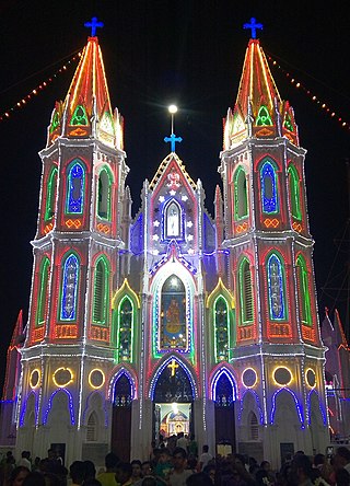
Velankanni (Vēḷāṅkaṇṇi), is a Special Grade Panchayat Town in Nagapattinam district in the Indian state of Tamil Nadu. It lies on the Coromandel Coast of the Bay of Bengal, 350 km south of Chennai (Madras), 12 km south of Nagapattinam, and 33 km southeast of Thiruvarur.

Eraniel is a panchayat town in Kanyakumari district in the state of Tamil Nadu, India. It is of major commercial and political importance in the history of South India, as it was the seasonal capital of the affluent Venad and later Travancore kingdoms until the seventeenth century, when Padmanabhapuram and Thiruvananthapuram rose to prominence. Currently it is known for its archaeological importance for the ruins of the dilapidated Eraniel Palace.

Dindigul is a city in the Indian state of Tamil Nadu. It is the administrative headquarters of the Dindigul district. Dindigul is located 420 km (260 mi) southwest from the state capital, Chennai, 100 km (62 mi) away from Tiruchirappalli,66 km (41 mi) away from Madurai and 72 km (45 mi) away from Karur. The city is known for its locks and biryani.
Palani (Tamil:[paɻani], is a town and a taluk headquarters in Dindigul district of the western part of Tamil Nadu state in India. It is located about 106 kilometres south-east of Coimbatore and 122 kilometres north-west of Madurai, 67 kilometres from Kodaikanal. The Palani Murugan Temple or Arulmigu Dhandayuthapani Swamy Temple, dedicated to Murugan is situated on a hill overlooking the town. The temple is visited by more than 7 million pilgrims each year. As of 2011, the town had a population of 70,467 and the Taluk had a population of 292,301 which makes it the second largest town in the district after Dindigul.
Arumuganeri is a panchayat town at Tiruchendur constituency from Thoothukudi district in the state of Tamil Nadu, India. In ancient times, the town was part of the Kuda Nadu division led by Korkai.

Batlagundu is a town in Nilakottai block in Dindigul district in the Madurai Region state of Tamil Nadu, India. The name Vetrilaikkundru later transformed and changed to Vathalagundu. The town is the major gateway to Kodaikanal. Subramaniya Siva was a writer, Indian Freedom Fighter, and activist born in Batlagundu. Batlagundu is the fifth-largest town in the Dindigul district. The town is located in such a way connecting three main districts of South Tamil Nadu. Batlagundu has most of the voters in Nilakottai Constituency.
Chinnalapatti is a Panchayat town in Dindigul district, Tamil Nadu in India with a total population of about 26285. In 2021 most of the wards are merged to accommodate it to 18 wards, as chinnalapatti is still a town panchayat. It is understood that the number of voters are 29000 and population would be around 42000. Making it the largest town panchayat in Dindigul district. The town is well known for the handloom sarees and garments. The place is located next to Sirumalai hills which has lot of grapes farmlands.

Lalgudi is a prominent municipality located in the Tiruchirapalli district of Tamil Nadu, India. This region has historical and cultural significance, serving as the administrative center for various divisions including Lalgudi taluk, Lalgudi Educational District, and Lalgudi DSP. Its importance stems from its governance structure, educational institutions, and constituency representation, as it has been part of the legislative assembly since 1952.
Madathukulam is Border to Dindigul District in Tirupur district in the Indian state of Tamil Nadu.

Udumalai, also known as Udumalaipettai and Udumalpet, is a town in Tiruppur district in the Indian state of Tamil Nadu. It is located 535 km south west from the state capital, Chennai and 72 km from Coimbatore. It is the headquarters of Udumalaipettai taluk and had a population of 61,133 as per 2011 Census of India. The town comes under the Udumalaipettai Assembly constituency.
Vasudevanallur is a town panchayat located 37 km from Tenkasi district in the Indian state of Tamil Nadu. It is located under the Western Ghats. This town is surrounded by farming land. Major occupation of people of this town seems farming especially paddy, sugarcane, lemon and etc., This town is being best for education among the district for both schooling and colleges.
Paramathi Velur, a town in Paramathi-Velur taluk, Namakkal District, Tamil Nadu, India is situated just off the Srinagar - Kanyakumari National Highway 44 (India). This town is also called as Paramathi Velur, with STD Code 04268 & Postal code 638182.

Pallapatti is one of three municipalities of Karur district in Tamil Nadu, India. The history of Pallapatti dates back 600 years. It is accessible from the NH 44 connecting Dindigul and Karur and is located 46 km (29 mi) from Dindigul and 35 km (22 mi) from Karur, which can be reached through Aravakurichi town. Pallapatti is a Tamil Muslim-majority town that emphasizes passing traditional and cultural values across generations. There are several mosques, a church and a temple. The Nankanji River flows through Pallapatti.
Eriyodu is a panchayat town located in Dindigul district of Madurai Region in the state of Tamil Nadu, India. It is a part of vedasandur legislative constituency and karur parliamentary constituency. Eriyodu is in the administrative district of Dindigul. Eriyodu is located in Dindigul next to Karur State Highway road.

Peikkarumbankottai is a village in the Orathanadu taluk of Thanjavur district, Tamil Nadu, India.
Semmanipatti, also called Semminipatti or Chemminipatti, is a village in the Indian state of Tamil Nadu. Situated at a distance of 29 kilometres (18 mi) North of Madurai and 3 kilometres (1.9 mi) south of Vadipatti on the National Highway.

Inam Kulathur is one of the Census Towns in Tiruchirappalli District in the Indian state of Tamil Nadu. The old names of the village is Vellang Kulathur.
Pandrimalai is a village panchayat located in the Dindigul district of Tamil Nadu, India. The latitude 10.3627476 and longitude 77.99234 are the geocoordinate of the Pandrimalai. Chennai is the state capital for Pandrimalai village. It is located around 393.6 kilometer away from Pandrimalai. The other nearest state capital from Pandrimalai is Thiruvananthapuram and its distance is 226.6 km. The other surrounding state capitals are Thiruvananthapuram 226.6 km., Pondicherry 266.4 km., Bangalore 294.4 km.,
Kethureddipatti is a Village Panchayat in Dharmapuri district of Tamil Nadu, India. It is located at 30 km (19 mi) from Dharmapuri town. It comes under Pappireddipatti taluk and Kadathur Block. It belongs to Pappireddipatti State Legislative Assembly Constituency and Dharmapuri Loksabha Constituency. It consists of nine panchayat wards. As per the 2011 Census, the total population of this village is 4,808.
