
Suldal is a municipality in the northeast corner of Rogaland county, Norway. It is located in the traditional district of Ryfylke. Since 1965, the administrative centre of Suldal is the village of Sand i Ryfylke. Other villages in Suldal include Hålandsosen, Jelsa, Marvik, Nesflaten, and Suldalsosen.

Etne is a municipality in Hordaland county, Norway. It is located in the traditional district of Sunnhordland, although it is also sometimes considered to be part of the district of Haugaland. The administrative centre of the municipality is the village of Etnesjøen. Other villages in the municipality include Skånevik and Fjæra. The two largest villages in the municipality are Etnesjøen with 1,159 residents and Skånevik with 594 residents.

Ryfylke is a traditional district in the northeastern part of Rogaland county, Norway. The 4,546-square-kilometre (1,755 sq mi) district is located northeast of the city of Stavanger and east of the city of Haugesund and it encompasses about 60% of the county's area. It includes the mainland located northeast and east of the Boknafjorden and east of the Høgsfjorden. It also includes the islands located on the south side of the Boknafjorden. To the east, Ryfylke borders the districts of Setesdal and Sirdal, to the south is Jæren, and to the west is Haugalandet. Ryfylke is one of the 15 districts in Western Norway.

Saudafjord or Saudafjorden is a fjord in Rogaland county, Norway. The fjord stretches from the town of Sauda in the municipality of Sauda in the north to the village of Sand in the municipality of Suldal where the Saudafjorden and Hylsfjorden join together to form the Sandsfjorden.
Grøsfjellvatnet is a lake in the municipalities of Eigersund, Lund, and Sokndal in Rogaland county, Norway. The 3.09-square-kilometre (1.19 sq mi) lake list just north of the lake Eiavatnet, about 4 kilometres (2.5 mi) west of the village of Heskestad in Lund municipality.

Tysdalsvatnet or Tyssdalsvatnet is a lake in the municipalities of Hjelmeland and Strand in Rogaland county, Norway. The 3.74-square-kilometre (1.44 sq mi) lake lies about 5 kilometres (3.1 mi) south of the village of Årdal and about 8 kilometres (5.0 mi) east of the village of Tau. The Norwegian National Road 13 (Rv13) runs along the northern side of the lake. The Svo Tunnel was completed in 2013 and it routes much of Rv13 through a mountain rather than along the narrow shoreline of the lake.
Vostervatnet is a lake in the municipality of Strand in Rogaland county, Norway. The 2.62-square-kilometre (1.01 sq mi) lake lies in the northwestern part of Strand, just south of the Fognafjorden. The village of Tau lies about 3.5 kilometres (2.2 mi) southwest of the lake. The main outflow of the lake is the river Fiskåna, which flows north from the northeastern corner of the lake, down the hill to the village of Fiskå on the shore of the fjord.
Ørsdalsvatnet or Ørdalsvatnet is a lake in the municipality of Bjerkreim in Rogaland county, Norway. The 12.22-square-kilometre (4.72 sq mi) lake lies about 2 kilometres (1.2 mi) northeast of the village of Bjerkreim. The lake is rather narrow, but it is 15 kilometres (9.3 mi) long.
Øvre Tysdalsvatnet is a lake in the municipality of Hjelmeland in Rogaland county, Norway. The 9-square-kilometre (3.5 sq mi) lake lies on the east side of the village of Årdal. The 12-kilometre (7.5 mi) long lake is only about 800 metres (0.5 mi) wide and it has a fairly steep shoreline, which results in very little habitation around the lake.
Austrumdalsvatnet is a lake in the municipality of Bjerkreim in Rogaland county, Norway. The 2.81-square-kilometre (1.08 sq mi) lake lies about 2.5 kilometres (1.6 mi) southeast of the lakes Hofreistæ and Byrkjelandsvatnet. The village of Øvrebygd lies about 3 kilometres (1.9 mi) west of the lake.
Byrkjelandsvatnet or Storavatnet is a lake in the municipality of Bjerkreim in Rogaland county, Norway. The 5.17-square-kilometre (2.00 sq mi) lake lies about 2 kilometres (1.2 mi) north of the village of Øvrebygd. The lake flows out through the short river Malmeisåna which flows into the lake Hofreistæ.

Holmavatnet is a lake the Setesdalsheiene mountains of Southern Norway. It is located on the border of the municipalities of Suldal, Vinje, and a small part in Bykle. The southeastern corner of the lake is in Bykle, and it is the northernmost part of all of Aust-Agder county. The lake Skyvatn is located about 5 kilometres (3.1 mi) to the south of the lake.

Saudasjøen is a village in Sauda municipality in Rogaland county, Norway. The village is located along the northern coast of the Saudafjorden about 3.5 kilometres (2.2 mi) southwest of the town of Sauda. For statistical purposes it is considered a part of the urban area of the town of Sauda. The village is mostly a bedroom community for the nearby town of Sauda. There are some small industries in Saudasjøen as well as the Saudasjøen Chapel. County Road 520 runs through the village along the shore of the fjord.
Hellandsbygda or Hellandsbygd is a village in Sauda municipality in Rogaland county, Norway. The village is located in a river valley about 12 kilometres (7.5 mi) northeast of the town of Sauda. The village is surrounded by forested mountains with the County Road 520 running through the village on its way from Sauda over the mountains to the Røldal area in neighboring Hordaland county. The mountain Kyrkjenuten lies to the north of Hellandsbygda and the mountain Skaulen lies to the southeast of the village.
Skaulen is a mountain in Rogaland county, Norway. The 1,538-metre (5,046 ft) mountain lies on the border of the municipalities of Sauda and Suldal. The mountain lies in the Ryfylkesheiane mountains, about 7.5 kilometres (4.7 mi) southeast of the village of Hellandsbygda in Sauda and about 13 kilometres (8.1 mi) west of the village of Nesflaten in Suldal.
Kyrkjenuten is a mountain in the municipality of Sauda in Rogaland county, Norway. The 1,602-metre (5,256 ft) tall mountain is the highest mountain in Sauda and also the 7th highest mountain in the county. It is located in northeastern Sauda, about 12 kilometres (7.5 mi) north of the village of Hellandsbygda and about the same distance southeast of the village of Fjæra in Etne municipality to the north of the mountain, just over the county border with Hordaland.
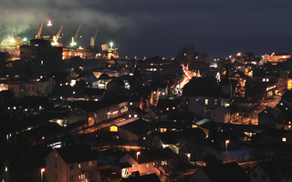
Sauda is a town in Sauda municipality in Rogaland county, Norway. The town, which is also the administrative centre of the municipality, is located in a river valley at the northern end of the Saudafjorden. The small suburb of Saudasjøen lies about 3 kilometres (1.9 mi) west of the town centre. A large part of the industrial harbour area of Sauda is built on reclaimed land that was once underwater in the fjord.

Sauda Church is the main parish church in Sauda municipality in Rogaland county, Norway. It is located in the town of Sauda. The church is part of the Sauda parish in the Ryfylke deanery in the Diocese of Stavanger.
Saudasjøen Chapel is a chapel in Sauda in Rogaland county, Norway. It is located in the village of Saudasjøen. The chapel is part of the Sauda parish in the Ryfylke deanery in the Diocese of Stavanger. The concrete chapel was built in 1973 and it seats about 300 people.


