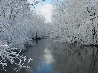
American Creek (also known as Crow Creek) is a stream in northwestern Bruele County, South Dakota, United States, that is a tributary of the Lake Francis Case reservoir on the Missouri River. [1] The creek's headwaters are just east of the town of Pukwana and its mouth is in the city of Chamberlain. In addition to the two communities, the creek flows through the Pukwana [2] and Chamberlain [3] townships.
Lake Wanalain [4] is a reservoir along the creek in the western part of Pukwana Township that is created by the Wanalain Lake Dam. [5]
American Creek received its name directly from Lewis and Clark. [6]

The Au Sable River is a 138-mile-long (222 km) river in the Lower Peninsula of the U.S. state of Michigan. Rising in the Northern Lower Peninsula, the river flows in a generally southeasterly direction to its mouth at Lake Huron at the communities of Au Sable and Oscoda. It is considered one of the best brown trout fisheries east of the Rockies and has been designated a blue ribbon trout stream by the Michigan Department of Natural Resources. A map from 1795 located in the United States Gazetteer calls it the Beauais River. In French, the river is called the Rivière au sable, literally "Sand River".

Billings Township is a civil township of Gladwin County in the U.S. state of Michigan. As of the 2020 census, the township population was 2,318.

Oscoda Township is a charter township of Iosco County in the U.S. state of Michigan. The population was 7,152 at the 2020 census. The Wurtsmith Air Force Base is located within the township.
The Paw Paw River is located in the U.S. state of Michigan in the southwest portion of the lower peninsula. It is formed by the confluence of the north and south branches at 42°15′17″N85°55′36″W in Waverly Township in the northeast of Van Buren County. It flows approximately 61.8 miles (99.5 km) through Van Buren County and Berrien County until joining the St. Joseph River just above its mouth on Lake Michigan at Benton Harbor.

The St. Joseph River is an 86.1-mile-long (138.6 km) tributary of the Maumee River in northwestern Ohio and northeastern Indiana in the United States, with headwater tributaries rising in southern Michigan. It drains a primarily rural farming region in the watershed of Lake Erie.

The Feather River is the principal tributary of the Sacramento River, in the Sacramento Valley of Northern California. The river's main stem is about 73 miles (117 km) long. Its length to its most distant headwater tributary is just over 210 miles (340 km). The main stem Feather River begins in Lake Oroville, where its four long tributary forks join—the South Fork, Middle Fork, North Fork, and West Branch Feather Rivers. These and other tributaries drain part of the northern Sierra Nevada, and the extreme southern Cascades, as well as a small portion of the Sacramento Valley. The total drainage basin is about 6,200 square miles (16,000 km2), with approximately 3,604 square miles (9,330 km2) above Lake Oroville.

Pine River may refer to any of the following rivers in the U.S. state of Michigan:

The San Jacinto River is a 42-mile-long (68 km) river in Riverside County, California. The river's headwaters are in Santa Rosa and San Jacinto Mountains National Monument. The lower portion of the 765-square-mile (1,980 km2) watershed is urban and agricultural land. As a partially endorheic watershed that is contiguous with other Great Basin watersheds, the western side of the San Jacinto Basin is a portion of the Great Basin Divide.

The Dowagiac River is a southwesterly flowing 30.9-mile-long (49.7 km) stream in the Lower Peninsula of the U.S. state of Michigan. It is a tributary to the St. Joseph River which flows, in turn, into eastern Lake Michigan.

The Cedar River is a 29.0-mile-long (46.7 km) river in the U.S. state of Michigan, flowing through Clare County and Gladwin County.

Lake Francis Case is a large reservoir impounded by Fort Randall Dam on the Missouri River in south-central South Dakota, United States. The lake has an area of 102,000 acres (410 km2) and a maximum depth of 140 ft (43 m). Lake Francis Case has a length of approximately 107 mi (172 km) and has a shoreline of 540 mi (870 km). The lake is the eleventh-largest reservoir in the United States and is located within the counties of: Charles Mix, Gregory, Lyman, Brule, and Buffalo. The lake stretches from Pickstown, South Dakota upstream to Big Bend Dam.

The Betsie River is a 54.0-mile-long (86.9 km) river in the U.S. state of Michigan. The river is located in the northwestern Lower Peninsula of the state, flowing into Lake Michigan at Frankfort. The river's course is mostly within Benzie County,, although the river rises in western Grand Traverse County and flows briefly through northern Manistee County.
Hylebos Creek is a stream located in the U.S. state of Washington near Tacoma and emptying into Commencement Bay, part of Puget Sound. It flows through southern King County and northern Pierce County, through the cities of Tacoma, Federal Way, Milton, and Fife, as well as the Puyallup Indian Reservation.

Boyne River is a stream in Northern Michigan, named for the River Boyne in Leinster, Ireland. Together with the north and south branches, the river system has approximately 22 miles (35 km) of mainstream and the water basin drains 40,320 acres (163.2 km2). Boyne River is Lake Charlevoix's second-largest tributary, after the Jordan River.

The Hersey River is a 13.4-mile-long (21.6 km) stream in the Lower Peninsula of the U.S. state of Michigan. It rises in Lincoln Township in northwest Osceola County at the junction of Hersey Creek and the East Branch Hersey Creek at 43°50′55″N85°25′59″W. For approximately the first two miles, the river flows southward just east of U.S. Route 131. US 131 crosses the river near the northern boundary of Richmond Township. The river continues southward into Lake No Sho Mo, formed by a dam just south of Nartron Field airport. The river continues southward under U.S. Route 10 into Reed City and turns to the east, continuing southeastward into the village of Hersey, where it empties into the Muskegon River at Blodgett's Landing Campground.

Temescal Creek is an approximately 29-mile-long (47 km) watercourse in Riverside County, in the U.S. state of California. Flowing primarily in a northwestern direction, it connects Lake Elsinore with the Santa Ana River. It drains the eastern slopes of the Santa Ana Mountains on its left and on its right the western slopes of the Temescal Mountains along its length. With a drainage basin of about 1,000 square miles (2,600 km2), it is the largest tributary of the Santa Ana River, hydrologically connecting the 720-square-mile (1,900 km2) San Jacinto River and Lake Elsinore watersheds to the rest of the Santa Ana watershed. However, flowing through an arid rain shadow zone of the Santa Ana Mountains, and with diversion of ground water for human use, the creek today is ephemeral for most of its length, except for runoff from housing developments and agricultural return flows.

The Pine River is a 103-mile-long (166 km) river in the Lower Peninsula of the U.S. state of Michigan. The Pine River is a tributary of the Chippewa River and is thus part of the Saginaw River drainage basin.

The Temescal Mountains, also known as the Sierra Temescal, are one of the northernmost mountain ranges of the Peninsular Ranges in western Riverside County, in Southern California in the United States. They extend for approximately 25 mi (40 km) southeast of the Santa Ana River east of the Elsinore Fault Zone to the Temecula Basin and form the western edge of the Perris Block.
43°48′56″N99°19′54″W / 43.81556°N 99.33167°W
| | This article related to a river in South Dakota is a stub. You can help Wikipedia by expanding it. |