The Tunisian Sahel or more precisely the Central East Tunisia Region is an area of Central eastern Tunisia and a one of the Six Tunisian Regions. It stretches along the eastern shore, from Hammamet in the north to Mahdia in the south, including the governorates of Monastir, Mahdia, Sfax, and Sousse. Its name derives from the Arabic word sāḥil (ساحل), meaning "shore" or "coast". The regions' economy is based especially on tourism and it contains the second biggest airport in Tunisia: Monastir Habib Bourguiba International Airport.

Ksibet El Mediouni is a small city located in the region of the Sahel in Tunisia around 10 km south Monastir. Its origins are thought to be linked to the establishment of an observation post of the Almoravids to control Christian incursion on this part of the Tunisian coast.
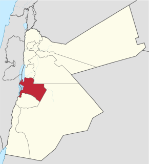
Karak is one of the governorates of Jordan, located south-west of Amman, Jordan's capital. Its capital is Al Karak. It borders Madaba and the Capital governorates to the north, Ma'an Governorate from the east, Tafilah Governorate from the south, and the Dead Sea form the west.
Stade Mustapha Ben Jannet is a multi-use stadium in Monastir, Tunisia. It is currently used by football team US Monastir, and was used for the 2004 African Cup of Nations. The stadium holds 20,000 people and sometimes, it's used as a home for Tunisia national football team
Bekalta, Arabic: البقالطة (al-Bikalita), is a Tunisian coastal town, around 30 km. south of Monastir and around 14 km. northeast of Mahdia. The main activities of the local population are agriculture and fishing.
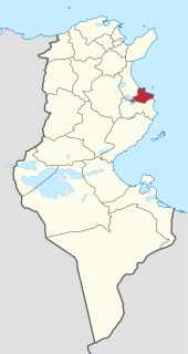
Sousse Governorate is one of the twenty-four governorates (provinces) of Tunisia. It is beside the eastern coast of Tunisia in the north-east of the country and covers an area of 2,621 km² and has a population of 674,971. The capital is Sousse.

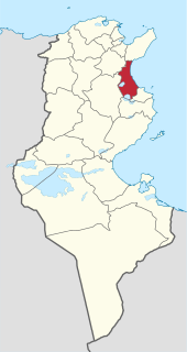
Mahdia Governorate is in central-eastern Tunisia, named after its largest town, its administrative centre. It comprises an area of coastal relative lowlands and is one of the twenty-four governorates (provinces). It covers an area of 2,966 km², extends further inland than its coastal length and has a population of 410,812. Three districts neighbour, clockwise from south, Sfax, Kairouan and Sousse Governorates.

The University of Monastir or UM is a is a Tunisian multidisciplinary university with its own financial and administrative autonomy located in Monastir, Tunisia. It was founded in 2004 following the reform of the university higher education education system and is organized in 5 Faculties, 2 graduate schools and 9 institutes.
Métouia, also spelled El Méthouia, is a town and commune in the Gabès Governorate, Tunisia. As of 2004 it had a population of 9,946. In summer, it increases to nearly 50 000 inhabitants due to the return of summer residents living abroad. Administratively, it has a municipality seat of 9,946 inhabitants and a delegation attached to the governorate of Gabès.
Cherahil is a town and commune in the Monastir Governorate, Tunisia.
Bouhjar is a town and commune in the Monastir Governorate, Tunisia.
El Masdour is a town and commune in the Monastir Governorate, Tunisia.
Messaadine is a town and commune in the Sousse Governorate, Tunisia. As of 2004 it had a population of 8,444.
Sidi El Hani is a town and commune in the Sousse Governorate, Tunisia located at 35.67n, 10.30e. As of 2004 it had a population of 3,058. It gives its name to the largest lake of the governorate, a natural salt lake or salt pan (sabkha) in dry seasons, the Sebkhet de Sidi El Hani which is shared with between one and two other areas depending on precipitation and its maximum extent forms the official boundary with part of a third, Monastir Governorate. The town is 30km south-west of the coast, its straightest connection being by Tunisian Railways, with a secondary connection by road, the P12 road which is a principal road to Kairouan from the A1 a few kilometres to the east. it is 19km from Kairouan and 26 km from Raqqada and.

Sayada is a city in the Sahel region of Tunisia. It is located about fifteen kilometers south of Monastir. It is part of the administrative governorate of Monastir, and is the county seat of the Sayada-Lamta-Bou Hajar Delegation which has a population of 22,944 people.

Téboulba is a town in the Sahel region of Tunisia. It is located about 25 kilometers south of Monastir. It is part of the administrative governorate of Monastir, and is the county seat of the Delegation with the same name, which has a population of 37,485 people.
Sidi Ameur is a city of the Tunisian Sahel located at 35° 45'n, 10° 42'e on the Mediterranean coast near Sahline, a few kilometers west of Monastir. The Mayor is Mustapha Attig