El Battan

Last updated
El Battan
البطان
Commune and town
El Batan.jpg
Tebourba el-battan.
CountryFlag of Tunisia.svg  Tunisia
Governorate Manouba Governorate
Government
  Mayor Mabrouka Salhi (People’s Movement)
Population
 (2014)
  Total6,458
Time zone UTC+1 (CET)

El Battan is a town and commune in the Manouba Governorate, Tunisia. As of 2004 it had a population of 5,761. [1] Attached to the governorate of Manouba, it is a municipality with 5,761 inhabitants in 2004 [2] and the capital of a delegation of 17,321 inhabitants.

El Batan is located at 36°48'13"N, 9°50'38"E, west of Tunis.

The city is in the center of a large plain where intensive irrigation is practiced. It is also known for the breeding of horses. There is a subsidiary of the National Foundation for the improvement of the horse race. During the French protectorate, El Battan was a strategic location for the settlement of farmers. French-style houses still exist there.

Extract of the Tabula Peutingeriana showing area around El Battan, during 4th century. Carthage Tabula Peutingeriana 2.png
Extract of the Tabula Peutingeriana showing area around El Battan, during 4th century.

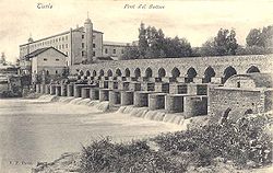
A bridge of Roman origin allows travelers to cross the Medjerda. Traditionally, washing and crushing of wool was practiced there, especially for the manufacture of the chechias.

El Battan. Tebourba el-battan.jpg
El Battan.

See also

Related Research Articles

Manouba Place in Manouba Governorate, Tunisia

Manouba is a city in north-eastern Tunisia, and is part the metropolitan area of Tunis, also called "Grand Tunis". It is located at the west of Tunis city center at around 36°48′28″N10°6′4″E. It is the capital city of Manouba Governorate.

Manouba Governorate Governorate of Tunisia

Manouba Governorate is one of the twenty-four governorates (provinces) of Tunisia and is in inland, northern Tunisia. It has a population of 379,518, and an area of 1,137 km2. The capital is Manouba.

Ben Arous Governorate Governorate of Tunisia

Ben Arous Governorate is one of the twenty-four governorates of Tunisia. It is in the north-east of Tunisia and adjoins smaller Tunis Governorate. It covers an area of 761 km² and had a population of 712,172 as at the 2019 census. The capital is Ben Arous.

Delegations of Tunisia Second level administrative divisions of Tunisia

The delegations of Tunisia (mutamadiyah) are the second level administrative divisions of Tunisia between the governorates and the sectors (imadats). As of 2006 there were 24 governorates which were divided into 264 delegations (mutamadiyat) and further divided into 2073 sectors. The delegations are listed below, organized by governorate.

Borj El Amri

Borj El Amri or Bordj El Amri is a town in the Manouba Governorate of Tunisia. It is located 30 kilometres (19 mi) southwest of Tunis.

Bou Mhel el-Bassatine is a town and commune in the Ben Arous Governorate, Tunisia. As of 2004 it had a total population of 27,977.

Métouia, also spelled El Méthouia, is a town and commune in the Gabès Governorate, Tunisia. As of 2004 it had a population of 9,946. In summer, it increases to nearly 50 000 inhabitants due to the return of summer residents living abroad. Administratively, it has a municipality seat of 9,946 inhabitants and a delegation attached to the governorate of Gabès.

Fernana Commune and town in Jendouba Governorate, Tunisia

Fernana is a town and commune in the Jendouba Governorate about 170 km from Tunis, Tunisia. In 2006 the municipal center of the commune had a population of 3206. It is now estimated to more than 5000 inhabitants. The whole commune has about 50,000 inhabitants. Most inhabitants work in agriculture, particularly in tobacco farming.

Oueslatia Commune and town in Kairouan Governorate, Tunisia

Oueslatia is a town and commune in the Kairouan Governorate, Tunisia. As of 2004 it had a population of 8,444. It is also the capital of a delegation with 36,195 inhabitants in the 2006 census.

Dahmani, formerly Abbah Quşūr, is a town and commune in the Kef Governorate, Tunisia. As of 2004 it had a population of 14,061. It is located at 625 meters above sea level, 225 kilometers southwest of Tunis.

Douar Hicher is a town and commune in the Manouba Governorate, Tunisia. It is known for the important political role that its inhabitants, especially the youth, played in the manifestations during the Tunisian revolution between December 2010 and February 2011.

<span class="mw-page-title-main">Djedeida</span> Commune and town in Manouba Governorate, Tunisia

Djedeida is a town and commune in the Manouba Governorate, Tunisia. It is about 25 km west of Tunis. As of 2021 it had a population of 45,000.

Oued Ellil Commune and town in Manouba Governorate, Tunisia

Oued Ellil is a town and commune in the Manouba Governorate, Tunisia. As of 2004, it had a population of 47,614.

Mornaguia is a town and commune in the Manouba Governorate, Tunisia, located 14 kilometres from Tunis. As of 2004 it had a population of 13,382.

El Mida is a town and commune in the Nabeul Governorate, Tunisia. As of 2004, it had a population of 3,437.

Korbous Commune and town in Nabeul Governorate, Tunisia

Korbous is a town and commune in the Nabeul Governorate, Tunisia. As of 2004 it had a population of 3,551.

Tazarka is a town and commune in the Nabeul Governorate, Tunisia. As of 2004 it had a population of 7,613.

Mezzouna is a town and commune in the Sidi Bou Zid Governorate, Tunisia. As of 2004 it had a population of 6,101.

Kesra Commune and town in Siliana Governorate, Tunisia

Kesra is a town and commune in the Siliana Governorate, Tunisia. As of 2004 it had a population of 2,490. In 2014 this was 2600. Kesra is in Siliana Governorate near Maktar at 35.8N and 9.36e. The town is at altitude of 966m and is near the Jebel Serj national park. During the Roman Empire Kesra was a civitas of the Roman Province of Byzacena called Cusira.

Le Kram Commune and town in Tunis Governorate, Tunisia

Le Kram is a town and commune in the Tunis Governorate of Tunisia. Situated between La Goulette, the port of Tunis, and Carthage, it opens onto the Gulf of Tunis to the east and the Lake of Tunis to the west. As of 2004 it had a population of 58,152. Before 2001, Le Kram was a municipal district within the municipality bordering La Goulette.

References

Coordinates: 36°49′N9°50′E / 36.817°N 9.833°E / 36.817; 9.833