Hassi El Ferid

Last updated
Hassi El Ferid
حاسي الفريد
Commune and town
CountryFlag of Tunisia.svg  Tunisia
Governorate Kasserine Governorate
Population (2004)
  Total 4 711
  Ethnicities Arab
  Religions Islam
Time zone CET (UTC+1)

Hassi El Ferid (Arabic : حاسي الفريد) is a town and commune in the Kasserine Governorate, Tunisia. As of 2004 it had a population of 4 711. [1] It is 35 km from Kasserine and 75 from Gafsa.

Kasserine Governorate Governorate in Tunisia

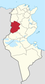
Kasserine Governorate, sometimes spelt Casrein, is one of the twenty-four governorates (provinces) of Tunisia. It is in west-central Tunisia on the frontier with Algeria, wholly north of the true centre line but the area is south or west of the bulk of the population of the country, based on Tunisia's greater northern rainfall. It covers an area of 8,260 km² and has a population of 459,232. The capital is Kasserine which is at the foot of Jebel ech Chambi, Tunisia's highest mountain, in turn part of the Dorsal Atlas mountains. The mountain and its associated escarpment form its own national park in the province.

Tunisia Country in Northern Africa

Tunisia (officially the Republic of Tunisia) is a country in the Maghreb region of North Africa, covering 163,610 square kilometres. Its northernmost point, Cape Angela, is the northernmost point on the African continent. It is bordered by Algeria to the west and southwest, Libya to the southeast, and the Mediterranean Sea to the north and east. Tunisia's population was 11.435 million in 2017. Tunisia's name is derived from its capital city, Tunis, which is located on its northeast coast.

Gafsa Place in Tunisia

Gafsa, originally called Capsa in Latin, is the capital of Gafsa Governorate of Tunisia. It lends its Latin name to the Mesolithic Capsian culture. With a population of 105,264, Gafsa is the 9th-largest Tunisian city.

See also

Related Research Articles

Battle of Kasserine Pass Battle of the Tunisia Campaign of World War II

The Battle of Kasserine Pass was a battle of the Tunisia Campaign of World War II that took place in February 1943. Kasserine Pass is a 2-mile-wide (3.2 km) gap in the Grand Dorsal chain of the Atlas Mountains in west central Tunisia.

Sevilleja de la Jara Place in Castile-La Mancha, Spain

Sevilleja de la Jara is a municipality located in the province of Toledo, Castile-La Mancha, Spain. According to the 2006 census (INE), the municipality has a population of 907 inhabitants.

Berdejo municipality in Aragon, Spain

Berdejo is a municipality located in the province of Zaragoza, Aragon, Spain. According to the 2004 census (INE), the municipality had a population of 66 inhabitants.

Caudiel in Castellón, Spain

Caudiel is a municipality in the comarca of Alto Palancia, Castellón, Valencia, Spain.

Thala, Tunisia Place in Kasserine, Tunisia

Tala is a town and commune in Tunisia. It is located in the Kasserine Governorate since 1956. As of the 2004 census it had 13,968 inhabitants. The altitude of Thala is 1,017 metres (3,337 ft), which makes it the highest and the coldest town in the country.

Neveklovice is a village and municipality in Mladá Boleslav District in the Central Bohemian Region of the Czech Republic.

Métlaoui Commune and town in Gafsa, Tunisia

Métlaoui is a town and commune in the Gafsa Governorate, Tunisia. In 2014 it had a population of 38,634.

Moularès, Tunisia Commune and town in Gafsa, Tunisia

Moularès is a town and commune in the Gafsa Governorate, Tunisia. At the 2004 census, it had a population of 24,487.

Redeyef Commune and town in Gafsa, Tunisia

Redeyef is a town and commune in the Gafsa Governorate, Tunisia. As of 2004 it had a population of 26,143. City industry is mainly based on mining.

Fériana is a town and commune in the Kasserine Governorate, Tunisia. As of 2004 it had a population of 26,504. It is 35 km from Kasserine and 75 from Gafsa.

Foussana in Kasserine Governorate, Tunisia

Foussana is a town and commune in the Kasserine Governorate, Tunisia. As of 2004 it had a total population of 41249; in 5622 the urban area and 35627 in the rural.

Jedelienne is a town and commune in the Kasserine Governorate, Tunisia. As of 2004 it had a population of 3,990.

Magel Bel Abbès is a town and commune in the Kasserine Governorate, Tunisia. As of 2004 it had a population of 5003.

Dahmani Commune and town in Kef Governorate, Tunisia

Dahmani, formerly Abbah Quşūr, is a town and commune in the Kef Governorate, Tunisia. As of 2004 it had a population of 14,061. It is located at 625 meters above sea level, 225 kilometers southwest of Tunis.

Korbous Commune and town in Nabeul Governorate, Tunisia

Korbous is a town and commune in the Nabeul Governorate, Tunisia. As of 2004 it had a population of 3,551.

Menzel Horr is a town and commune in the Nabeul Governorate, Tunisia. As of 2004 it had a population of 4,798.

El Hamma du Jérid is a town and commune in the Tozeur Governorate, Tunisia. As of 2004 it had a population of 6,259.

Guinagourou is a town and arrondissement in the Borgou Department of Benin. It is an administrative division under the jurisdiction of the commune of Pèrèrè. According to the population census conducted by the Institut National de la Statistique Benin on February 15, 2002, the arrondissement had a total population of 11,411.

References

Coordinates: 34°57′N8°34′E / 34.950°N 8.567°E / 34.950; 8.567

Geographic coordinate system Coordinate system

A geographic coordinate system is a coordinate system that enables every location on Earth to be specified by a set of numbers, letters or symbols. The coordinates are often chosen such that one of the numbers represents a vertical position and two or three of the numbers represent a horizontal position; alternatively, a geographic position may be expressed in a combined three-dimensional Cartesian vector. A common choice of coordinates is latitude, longitude and elevation. To specify a location on a plane requires a map projection.