
Srikakulam is a city and the headquarters of Srikakulam district in the Indian state of Andhra Pradesh. As of 2011 census, it has a population of 165,735. There are many other places of Buddhist Tourism such as Salihundam, Kalinga Patnam, Dabbaka Vaani Peta, Nagari Peta, Jagati Metta, Singupuram etc. in Srikakulam District. The Buddhist heritage site of Salihundam has some unique features. It has a beautiful star atop a stupa, rock cut massive stupas inside chaitya grihas, brick stupas with wheel pattern plan, votive stupas, inscriptions on the steps leading to the stupas and museum housing over two dozen sculpted statue and figurines of Buddha, Jain Teerthankars and other deities.
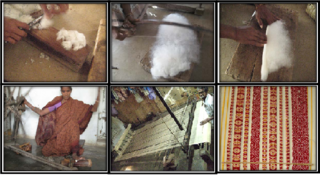
Dharmavaram is a city in Sri Sathya Sai District of the Andhra Pradesh state of Indian country. It is mandal and divisional headquarters of Dharmavaram mandal and Dharmavaram revenue division respectively. The city is known for its handloom silk sarees. The city is renowned for cotton, silk weaving industries and leather puppets. The city is called as Silk city of Andhra Pradesh. Dharmavaram is famous for Handloom Weavers, Saree Designs, Jacquard designs, Silk Extraction from Silkworm Cacoons, Dyeing and it is fully populated by maximum weavers and by developing technology makes changes by producing various types of machine equipment emerging for weavers to weave quickly than the past decades and quality production was happening now and the production was famous for Sarees.

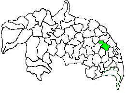
Vizianagaram district is one of the six districts in the Uttarandhra region of the Indian state of Andhra Pradesh with its headquarters located at Vizianagaram. The district was once the part of ancient Kalinga.Saripilli Dibbilingeswara temple, Jayathi Mallikarjuna Temple are the finest examples of ancient Eastern Ganga Dynasty built monuments in the district. The district is bounded on the east by the district of Srikakulam, north by Parvathipuram Manyam south by Visakhapatnam, Anakapalli, southeast by the Bay of Bengal, and west by Alluri Sitharama Raju district. It was formed on 1 June 1979, with some parts carved from the neighbouring districts of Srikakulam and Visakhapatnam. The district is named after the princely state of Vizianagaram. In 2011, it was the least populous district in Andhra Pradesh.

Visakhapatnam district is one of the six districts in the Uttarandhra region of the Indian state of Andhra Pradesh, headquartered at Visakhapatnam. It is one of the twenty-six districts in Andhra Pradesh state. The district shares borders within the north and east, Vizianagaram district and South Anakapalli district in the south-west and Bay of Bengal in the south.

Gajuwaka is a major residential area of Visakhapatnam City, India. This neighborhood of Visakhapatnam is considered the biggest shopping district in Andhra Pradesh by revenue. Though conceived as a residential locality, it is now one of the principal shopping districts of the city. The Gajuwaka area of Visakhapatnam has the highest per capita income in Andhra Pradesh.

Tadepalligudem is a city in West Godavari district of the Indian state of Andhra Pradesh. It is a Selection Grade municipality and the mandal headquarters of Tadepalligudem mandal and Tadepalligudem Revenue Division. Tadepalligudem is one of the biggest City in West Godavari district
Ponduru is a census town in Srikakulam district of the Indian state of Andhra Pradesh. The town is the mandal headquarters of Ponduru mandal in Srikakulam revenue division. It falls under the Amadalavalasa Assembly Constituency and Srikakulam Loksabha Constituency.

Narasannapeta is a census town in Srikakulam district of the Indian state of Andhra Pradesh. It is the mandal headquarters of Narasannapeta mandal in Srikakulam revenue division. 43 villages are there under the administrative division of Narasannapeta.

Pendurthi is a neighbourhood in the city of Visakhapatnam, India. The neighbourhood is considered as the major residential and commercial area in the city. It is located within the jurisdiction of the Greater Visakhapatnam Municipal Corporation, which is responsible for the civic amenities in Pendurthi. It is located on the west fringe of Visakhapatnam city. Pendurthi is one of the peaceful neighborhoods of Western Vizag. The pincode of Pendurthi is 531173.
Visakhapatnam Rural Mandal is one of the 46 mandals in Visakhapatnam district of Andhra Pradesh, India. The mandal lies on the coast of Bay of Bengal and is bounded by Bheemunipatnam, Anandapuram mandals to the north and Visakhapatnam Urban-1 to the south.

Dhone or Dronachalam is a town in Nandyal district of the Indian state of Andhra Pradesh. It is a municipality located in Dhone mandal, and it is the head quarters of Dhone revenue division.
Tenali mandal is one of the 18 mandals in Guntur district of the Indian state of Andhra Pradesh. It is under the administration of Tenali revenue division, headquartered at Tenali. The mandal is located in Velanadu region, bounded by Pedakakani, Duggirala, Kollipara, Vemuru, Amruthalur, Tsundur and Chebrole mandals.

Duggirala mandal is one of the 18 mandals in Guntur district of the Indian state of Andhra Pradesh. It is under the administration of Tenali revenue division and the headquarters are located at Duggirala. The mandal is bounded by Mangalagiri, Pedakakani, Tenali and Kollipara mandals. Krishna River lies to the northeast of the Duggirala mandal.

Machilipatnam mandal is one of the 25 mandals in Krishna district of the Indian state of Andhra Pradesh. It is under the administration of Machilipatnam revenue division, and the headquarters are located in Machilipatnam town. The mandal is bounded by Bantumilli, Pedana, Gudur, Ghantasala, Challapalli, and Koduru mandals.
Narakoduru is a village in Guntur district of the Indian state of Andhra Pradesh. It is the headquarters of Bollapalle mandal in Tenali revenue division. It is located in Chebrolu mandal of Tenali revenue division.
Renigunta mandal is one of the 34 mandals in Tirupati district of the Indian state of Andhra Pradesh. Its headquarters are located at Renigunta, suburb of Tirupati.. The mandal is bounded by Tirupati (urban), Tirupati (rural), Vadamalapeta, Yerpedu.This mandal is located at Srikalahasti revenue division.
Ramabhadrapuram mandal is one of the 34 mandals in Vizianagaram district of Andhra Pradesh, India. Ramabhadrapuram is the headquarters of the mandal. The mandal is bounded by Salur, Bobbili, Badangi, Merakamudidam, Dattirajeru, Mentada and Pachipenta mandals.

Anakapalli revenue division is an administrative division in the Anakapalli district of the Indian state of Andhra Pradesh. It is one of the two revenue divisions in the district which consists of twelve mandals under its administration. Anakapalli is the divisional headquarters.
Golagam is a village in Anakapalli district of the Indian state of Andhra Pradesh. It is located in gurla Mandal of gurla. It is located at a distance of 1 km from gurla and at a distance of 1 km from vizayanagaram.
Anakapalli mandal is one of the mandals in located in Anakapalli district of the state of Andhra Pradesh, India. It is administered under Anakapalli revenue division and its headquarters are located at Anakapalli. It is bounded by Kasimkota Mandal towards west, Munagapaka Mandal towards South, Paravada Mandal towards East, Achutapuram Mandal towards South.

