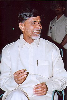
Nara Chandrababu Naidu is an Indian politician who has been Chief Minister of Andhra Pradesh since 2014. He is the first chief minister of the state since it was divided. Previously he served as Chief Minister of United Andhra Pradesh from 1994 to 2004, before the state was divided, and as the Leader of the opposition in the United Andhra Pradesh Legislative Assembly from 2004 to 2014. He is currently the National President of Telugu Desam Party.
Mangalagiri is a town in Guntur district situated between the twin cities of Vijayawada and Guntur of the Indian state of Andhra Pradesh. The town is the headquarters of Mangalagiri mandal under Guntur revenue division. It is a major suburb of the cities of Vijayawada and Guntur. It also forms a part of the Andhra Pradesh Capital Region. It is situated on National Highway 16 between Vijayawada and Guntur. The town was known to have existed since 225 B.C.. It is also a part of Andhra Pradesh Capital Region with a population of 73,613.

West Godavari district or Paschima Godavari Jilla is one of the 13 districts in the Indian state of Andhra Pradesh. The district is situated in Coastal Andhra region of the state. The administrative headquarters of the district is situated at Eluru. As of 2011 census of India, the district has an area of 7,742 km2 (2,989 sq mi) and a population of 3,936,966. It is bounded by Krishna district on the west, East Godavari district on the east, Bay of Bengal on the south and the state of Telangana on the north.

Gudivada is a town in Krishna district of the Indian state of Andhra Pradesh. It is a municipality and the headquarters of Gudivada mandal in Gudivada revenue division. It is one of the cities in the state to be a part of Andhra Pradesh Capital Region. It is Twenty sixth most populous city in the state with a population of 1,18,167.

Chittoor district, is a district in Rayalaseema region of the Indian state of Andhra Pradesh. The district headquarters is located at Chittoor. It has a population of 4,170,468 according to 2011 census of India. Chittoor district has many major temples including Tirupati, Srikalahasti and Kanipakam and other temples. It lies in the Poini river valley of southernmost Andhra Pradesh along the Chennai – Bangalore section of Chennai-Mumbai highway. It is a major market centre for mangoes, grains, sugarcane, and peanuts.Sricity integrated business city lies in Satyavedu mandal acts as a major industrial hub for chittoor district as well as Andhra Pradesh as a whole.

Anantapur district is a district in the Rayalaseema region of Andhra Pradesh, India. The district headquarters is located at Anantapur city. As of 2011 Census, the district had a population of 4,083,315, of which 28.09% is urban and a literacy rate of 64.28%. It is the largest district in terms of area in Andhra Pradesh and 7th largest district in India respectively.

Kurnool District is one of the 13 districts in the state of Andhra Pradesh, India. The district is located in the west-central part of the state and is bounded by Mahabubnagar district of Telangana in the north, Raichur district of Karnataka in the northwest, Bellary district of Karnataka in the west, Ananthapur district in the south, YSR Kadapa district in the South East and Prakasham district in the east. The city of Kurnool is the headquarters of the district. It has a population of 4,053,463 of which 28.35% were urban as of 2011. The district is the 10th largest district in the country and the 2nd largest district in the state, accounting for 17,658 square kilometres (6,818 sq mi).

Visakhapatnam District is a district in the Indian state of Andhra Pradesh. It is one of the nine coastal districts in the state, with the administrative headquarters located at Visakhapatnam. It is surrounded by Vizianagaram district on the north and East Godavari district on the south.

Acharya N. G. Ranga Agricultural University (ANGRAU) is a public agricultural university with its headquarters at the village Lam, Guntur City.
Mandapeta, also called as Mandavyapuram is a town and A-grade municipality in East Godavari district in the Indian state of Andhra Pradesh. It is a market and place of recreation for many surrounding villages and it is famous for its rice mills.
Venkatagiri is a town in Nellore district of the Indian state of Andhra Pradesh. It is a municipality and mandals headquarters of Venkatagiri mandal. Venkatagiri's old name is "Kali Mili". It is famous for its Handloom Cotton Sarees. Venkatagiri is a place for history and handlooms. It was part of a small kingdom that was integrated into the Indian Republic.
Chilakaluripet is a city in Guntur district of the Indian state of Andhra Pradesh. It is the mandal headquarters of Chilakaluripet mandal in Narasaraopet revenue division.
Sattenapalle is a town in Guntur district of the Indian state of Andhra Pradesh. It is a municipality and the headquarters of Sattenapalle mandal under Guntur revenue division.
Andhra Pradesh has many institutes of higher education along with numerous primary and secondary schools. The government also implements Fee Reimbursement Scheme for the economically backwards sections of the state.

Damodaram Sanjivayya National Law University (DSNLU) is located at Sabbavaram, Visakhapatnam, Andhra Pradesh, India constituted by the DSNLU Act, 2008. It offers 5 year integrated B.A LLB. (Hons.) course to eligible Undergraduate students based on the Common Law Admission Test centralized admission process. The University offers postgraduate courses also, including the one-year LL.M. programme and, PhD and LL.D. programmes. The university is housed at Nyayaprastha in Sabbavaram with 15.5 acres built up area in the first phase. The establishing Act of 2008 of the Andhra Pradesh Legislative Assembly, had provided the main campus at Visakhapatnam and two centers, at Kadapa and Nizamabad. These centres were subsequently removed by the DSNLU (Amendment) Act, 2016. The University is fully residential.
Andhra Pradesh Tribal Welfare Residential School (Boys) Eturnagaram, (A.P.T.W.R. School, Eturnagaram) is a residential school set up by a state government in India. The school was established in 1984 by the Andhra Pradesh State Government in the small village of Eturnagaram in Warangal district, Telangana Region

Amaravati is the de facto capital city of the Indian state of Andhra Pradesh. The planned city is located on the southern banks of the Krishna river in Guntur district, within the Andhra Pradesh Capital Region, being built on a 217 sq km riverfront designed to have 51% of green spaces and 10% of water bodies. The word "Amaravati" derives from the historical Amaravathi Temple town, the ancient capital of the Satavahana dynasty. The foundation stone was laid on 22 October 2015, at Uddandarayunipalem area by the Prime Minister, Narendra Modi. The metropolitan area of Guntur and Vijayawada are the major conurbations of Amaravati.

National Highway 326 is a National Highway in the Indian states of Andhra Pradesh and Odisha. It was formed as a new highway by up-gradation of former state highways of the states. It starts at Asika of Odisha and ends at Chinturu road of Andhra Pradesh.
National Highway 565, is a National Highway in India, which was formed as a new National Highway by up-gradation and passes through the state of Andhra Pradesh. It starts at Nakrekal of Telangana and ends at Renigunta of Andhra Pradesh.


