Andrews, Nebraska | |
|---|---|
 Andrews, Nebraska  Andrews, Nebraska | |
| Coordinates: 42°37′53″N103°55′02″W / 42.63139°N 103.91722°W | |
| Country | |
| State | |
| County | Sioux |
Andrews is an unincorporated community in Sioux County, Nebraska, United States. [1]
Andrews, Nebraska | |
|---|---|
| Andrews, Nebraska Andrews, Nebraska | |
| Coordinates: 42°37′53″N103°55′02″W / 42.63139°N 103.91722°W | |
| Country | |
| State | |
| County | Sioux |
Andrews is an unincorporated community in Sioux County, Nebraska, United States. [1]
A post office was established at Andrews in 1906, and remained in operation until it was discontinued in 1951. [2] Sources on the etymology of the name differ. It was either named for J. W. Andrews, a railroad engineer, [3] or for a pioneer settler. [4]
{{cite book}}: CS1 maint: ignored ISBN errors (link) A 1925 edition is available for download at University of Nebraska—Lincoln Digital Commons. Municipalities and communities of Sioux County, Nebraska, United States | ||
|---|---|---|
| Village | 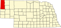 | |
| Unincorporated communities | ||
42°37′53″N103°44′02″W / 42.63139°N 103.73389°W
| | This Sioux County, Nebraska state location article is a stub. You can help Wikipedia by adding missing information. |