
Washington is a large town in the City of Sunderland local government district of Tyne and Wear, England, and part of historic County Durham. Washington is located geographically at an equal distance from the centres of Newcastle, Durham and Sunderland, hence it has close ties to all three cities.

Hvolsvöllur is a small town in the south of Iceland about 106 km to the east of Reykjavík.

Aberchirder, known locally as Foggieloan or Foggie, is a village in Aberdeenshire, Scotland, situated on the A97 road six miles west of Turriff.

Hannington is a village in the Daventry district of the county of Northamptonshire in England. At the time of the 2011 census the parish's population was 251 people.

Mullumbimby is an Australian town in the Byron Shire in the Northern Rivers region of New South Wales. It promotes itself as "The Biggest Little Town in Australia". The town lies at the foot of Mount Chincogan in the Brunswick Valley about 9 kilometres by road from the coast. At the 2016 census, Mullumbimby and the surrounding area had a population of 3,596 people. Locals refer to the town either as "Mullum" or "Bimby".

Zeerust is a commercial town situated in Ngaka Modiri Molema district North West Province, South Africa. It lies in the Marico valley, approximately 240 kilometres northwest of Johannesburg. It lies on the N4, the main road link between South Africa and Botswana. There are large cattle ranches in the area, as well as wheat, maize, tobacco and citrus fruit farms. There are also fluorite and chromite mines in the vicinity. Tourism is also a developing industry.

Ugar Khurd is a town municipal council in the district of Belagavi, in the state of Karnataka, in India. Khurd and Kalan Persian language word which means small and Big respectively when two villages have same name then it is distinguished as Kalan means Big and Khurd means Small with Village Name.

Shercock is a small town situated in the east of County Cavan, Ireland. As of the 2016 census, the population of the town was 588.
The "garden city" suburb of Pinelands is a middle class suburb located on the edge of the southern suburbs of Cape Town, South Africa, neighbouring the suburb of Thornton, and is known for its large thatched houses and green spaces. The suburb is primarily residential and is often praised for its peacefulness and abundance of trees. Pinelands is one of the few areas in Cape Town in which sale of alcohol to the public is prohibited, but some clubs have private liquor licenses. It is a popular place for senior citizens to retire to. While there are several retirement homes in the suburb, younger people are increasingly moving in.

Crynant is a village and community in the Dulais Valley in Wales. It lies 7¾ miles north-east from the town of Neath in Neath Port Talbot, lying between the mountains of Mynydd Marchywel to the west, Hirfynydd to the east and Mynydd y Drum to the north.

Newport is a large village in Essex near Saffron Walden. The village has a population of over 2,000, measured at 2,352 at the 2011 census.

Maratea is a town and comune of Basilicata, in the province of Potenza. It is the only comune of the region on the Tyrrhenian coast, and is known as "the Pearl of the Tyrrhenian". Owing to the considerable number of its churches and chapels it has also been described as "the town with 44 churches".

Vršački Ritovi is a village located in Serbia at 45° 9' 38" North, 21° 10' 19" East. It is situated in the Vršac municipality, in Banat region, Vojvodina province.

Sutton is a village and civil parish near Dover in Kent, England. In 1935 this village became a parish when the small settlements of Studdal, Sutton, Ashley, Little Mongeham and Maydensole joined to become the Parish of Sutton-by-Dover. Prior to this Sutton has had a vast history of agricultural practices, which has helped sustain the village into the parish it is today. The quoted population includes the villages of East and West Studdal plus Swingate and the hamlet of Little Mongeham.
Espergærde is a town situated in North Zealand near Øresund in Denmark and is statistically considered part of the larger urban area Espergærde-Snekkersten-Elsinore, some 5 to 8 km south of the centre of Elsinore and in reality separated from the urban area of Elsinore-Snekkersten by a 100 m wide unbuilt area, Egebæksvang forest and area under natural protection around Flynderupgård. The urban area of Espergærde also covers the two former villages Tibberup and Mørdrup and part of the former fishing village of Skotterup, with 11.524 inhabitants (2008). Espergærde is well limited to the north by Egebæksvang forest and Flynderupgård, to the west by Rolighedsmoserne and Helsingørmotorvejen, to the south by Krogerup mansion fields and Babyloneskoven. Espergærde is part of Region Hovedstaden.

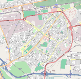
Redditch is a town and local government district in north-east Worcestershire, England. The town is divided into separate districts. All street-name signs in Redditch have the street name in white lettering on a blue background and the district name in black lettering on a white background at the bottom of the sign. In the New Town areas the roads are usually named in alphabetical order and house numbering in the cul-de-sac closes is consecutive, starting with number 1 as the first house on the left as you enter, and the highest house number will be on the opposite side of the road as you leave.
Chhatiwan is a Village Development Committee in Doti District in the Seti Zone of western Nepal. At the time of the 1991 Nepal census it had a population of 3000 residing in 478 individual households. The name for this VDC comes from a lake that is situated in the village of Chhatiwan. This lake has fresh drinking water and teamed with various kind of fish. Lately due to the deforestation and soil erosion, this lake is being filled with all debris coming in due to the flash flood from its North side of the mountain. Budar is the major town of this VDC and at this town Dadeldhura and Jogbuda roads cross. Some of the major villages in this VDC are Budar, Ritha, Phaltude, Dharapani, Chhatiwan, Chhahara and many others. There are two small mountain streams that eventually meet up at Deujaal. A stream that comes from the Chhahara village has a wonderful water fall. The name of the water fall itself is Chhahara. In Nepali "Chhahara" means water fall. Once in a year there is a special festival at the foot of this water fall where people from many surrounding villages come and celebrate throughout the night. The festival begins in the evening and people sing, dance and merry all through the night. This is also the night when lovers elope if the family does not agree for their marriage. Along the stream grows a plant called "sisnu". This plant has mild poisonous element and once the Caterpillar type of hairy things get stuck in the skin, the skin will be burning for a long time. But the belief is that once in a year after the festival you have to be stung by that plant so that you will remain healthy throughout that year. So, people will be chasing each other in the morning to torture each other with that plant. Some times drinking creates big fights among the villager.
Chhatiwan VDC is also popular for a model school in far west Nepal. Rampur School is the oldest school and now it has school for the disabled children for the whole of Far west. There is also an Army School in Budar. During the construction of Dadeldhura Highway, Budar was very important place as it was the headquarters for the road construction department.

Aggeneys is a mining town established in 1976 on a farm of that name, situated between Pofadder and Springbok in the Northern Cape, South Africa.

Moneenroe is a townland, electoral division and village in north County Kilkenny, Ireland. It is located in the province of Leinster along the N78 road about 21 kilometres (13 mi) from Kilkenny city in the south-east of the island of Ireland. Moneenroe is a census town with a population of about 688.
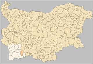
Garmen Municipality is situated in the southeastern part of Blagoevgrad Province in Southwestern Bulgaria. It is a rural municipality, composed of 16 villages. The administrative center is the village of Garmen, but the most populated village is Ribnovo. The municipality lies in the western part of the Rhodope mountains.
