Jallah Jeem

Last updated

جلّہ جِيم
City
Jallah Jeem
Roadmumbaiindia.jpg
A city street in Jallah jeem with left-hand traffic
Pakistan location map.svg
Red pog.svg
جلّہ جِيم
Location in Pakistan
Coordinates: 29°32′N71°38′E / 29.533°N 71.633°E / 29.533; 71.633
Country Pakistan
Region Punjab
District Vehari District
Government
[1]
  TypeMunicipal committee
  ChairmanJahangir Khan
Area
  Metro
10 km2 (4 sq mi)
Elevation
116 m (383 ft)
Population
  City57,382 (2,017)
 62,000
Time zone UTC+5 (PST)
  Summer (DST) UTC+6 (PDT)
PK
61230 (Post Office)
Area code 067 (Landlines)
GDP/PPP $12 billion (2021)

Jallah Jeem (Urdu : جلّہ جِيم) is the third largest city in the Vehari District of Punjab, Pakistan. [3]

Contents

Location

It is located 10 kilometres (6.2 mi) in the north-west of Mailsi, and is 17 kilometres (11 mi) from Mailsi-Syphon Bridge on Sutlej river. The exact location is N+29° 43' 7", E+72° 8' 4". [4]

Towns and union councils

Towns in Jallah Jeem:

TownsUnion Council
Fateh pur (Bahawalpur) [5] 1
Niyaz pur [5] 2
warsi wahan [5] 3
Islam pura [5] 4
kikri [5] 5
Thalla [5] 6

Fateh pur (Bahawalpur) It is a town in Bahawalpur district and under Union council(1) the settlement of tehsil Jallah Jeem. Niyaz pur, Arain wahan It is a town and under Union council(2) the settlement of tehsil Jallah jeem. Warsi wahan, Qadeer pur It is a townand under Union council(3) the settlement of tehsil Jallah jeem.

Religions in Jallah jeem
(2017 Census) [6]

   Muslims (99.3%)
   Christians (0.7%)

Location

It is located 10 kilometres (6.2 mi) in the north-west of Mailsi, and is 17 kilometres (11 mi) from Mailsi-Syphon Bridge on Sutlej river. The exact location is N+29° 43' 7", E+72° 8' 4". [4]

Geography and climate

Jallah Jeem is located in the Indus Valley near the city of Multan in central Pakistan. The area around the city is a flat, alluvial plain. The canals which cut across the tehsil provide irrigation. The Indus Water Treaty sold the water in the Sutlej river to India. The reduced water flow in the river had a pronounced effect on the flora and fauna of the area. The Jallah and Mailsi Siphon was built to control the water flow in the Sidhnai Link Canal and Sutlej river under the treaty. Jallah Jeem has an arid climate with hot summers and mild winters. It has some of the most extreme weather in the country. The highest recorded temperature is 54 °C (129 °F), and the lowest recorded temperature is −1 °C (30.2 °F). The average rainfall is 127 millimeters (5.0 in). Dust storms are a common occurrence within the city.

It is located at 29°48'1N 72°10'33E at an altitude of 126 m (416 ft). [7]

Climate data for Jallah Jallah jeem1981–2010, extremes 1952–2012
MonthJanFebMarAprMayJunJulAugSepOctNovDecYear
Record high °C (°F)31.7
(89.1)
36.7
(98.1)
42.8
(109.0)
44.9
(112.8)
49.0
(120.2)
47.2
(117.0)
46.7
(116.1)
41.7
(107.1)
41.7
(107.1)
40.0
(104.0)
36.4
(97.5)
32.0
(89.6)
49.0
(120.2)
Mean maximum °C (°F)27.2
(81.0)
31.4
(88.5)
37.1
(98.8)
41.9
(107.4)
44.3
(111.7)
43.7
(110.7)
39.4
(102.9)
36.1
(97.0)
37.5
(99.5)
36.9
(98.4)
33.1
(91.6)
28.3
(82.9)
44.8
(112.6)
Mean daily maximum °C (°F)22.6
(72.7)
25.7
(78.3)
31.6
(88.9)
37.4
(99.3)
40.7
(105.3)
39.6
(103.3)
34.6
(94.3)
32.7
(90.9)
34.2
(93.6)
33.8
(92.8)
29.3
(84.7)
24.5
(76.1)
32.2
(90.0)
Mean daily minimum °C (°F)8.6
(47.5)
11.4
(52.5)
16.8
(62.2)
22.2
(72.0)
26.5
(79.7)
27.7
(81.9)
26.1
(79.0)
24.8
(76.6)
23.6
(74.5)
19.6
(67.3)
14.0
(57.2)
9.5
(49.1)
19.2
(66.6)
Mean minimum °C (°F)3.8
(38.8)
6.1
(43.0)
11.3
(52.3)
16.7
(62.1)
20.9
(69.6)
22.2
(72.0)
23.1
(73.6)
22.3
(72.1)
20.8
(69.4)
15.2
(59.4)
9.1
(48.4)
4.8
(40.6)
3.8
(38.8)
[ citation needed ]

Languages of Punjab, Pakistan
(2017 Census) [6]

   Haryanvi (30%)
   Saraiki (25%)
   Urdu (20%)
   Punajbi (15%)
   Balochi (5%)
   Sindhi (3%)
  Others (2%)

Education

Educational LevelGradeAge
Primary (elementary school)1 to 56 to 10 [5]
Junior Secondary (middle school)6 to 811 to 13 [5]
Secondary (high school)9 to 1014 to 15 [5]
Higher Secondary (college/university)11 to 1216 to 17 [5]

Related Research Articles

<span class="mw-page-title-main">Cholistan Desert</span> Desert in Punjab, Pakistan

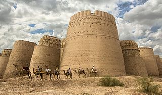
The Cholistan Desert, also locally known as Rohi, is a desert in the southern part of Punjab, Pakistan that forms part of the Greater Thar Desert, which extends to Sindh province and the Indian state of Rajasthan. It is one of two large deserts in Punjab, the other being the Thal Desert. The name is derived from the Turkic word chol, meaning "sands," and istan, a Persian suffix meaning "land of."

<span class="mw-page-title-main">Ravi River</span> River in India and Pakistan

The Ravi River is a transboundary river crossing northwestern India and eastern Pakistan. It is one of five rivers associated with the Punjab region.

<span class="mw-page-title-main">Sutlej</span> River in Asia

The Satluj River is the longest of the five rivers that flow through the historic crossroads region of Punjab in northern India and Pakistan. The Sutlej River is also known as Satadru. It is the easternmost tributary of the Indus River. The Bhakra Dam is built around the river Sutlej to provide irrigation and other facilities to the states of Punjab, Rajasthan and Haryana.

<span class="mw-page-title-main">Bahawalpur District</span> District of Punjab in Pakistan

Bahawalpur District is a district of Punjab, Pakistan, with capital the city of Bahawalpur. According to the 1998 Census it had a population of 2,433,091, of which 27.01% were urban. Bahawalpur district covers 24,830 km2. Approximately two-thirds of the district (16,000 km2) is covered by the Cholistan Desert, which extends into the Thar Desert of India. The district is a major producer of cotton.

<span class="mw-page-title-main">Vehari</span> City in Punjab, Pakistan

Vehari also spelled Vihari, is a city and the headquarters of Vehari District in the Punjab province of Pakistan. It is Pakistan's 62nd largest city. Vehari is about 100 km (62 mi) from the historical city of Multan. Vehari is located at the Multan-Delhi Road constructed by Emperor Sher Shah Suri. It is at an altitude of 135 m (443 ft).,{chak No 65.kb}

<span class="mw-page-title-main">Vehari District</span> District in Punjab, Pakistan

Vehari District is a district in the Punjab province of Pakistan. The city of Vehari is the capital of district while Burewala is the largest city and Jallah Jeem is the third largest city of the district.

<span class="mw-page-title-main">Multan District</span> District of Punjab in Pakistan

Multan District, is a district in the province of Punjab, Pakistan. Its capital is the city of Multan. The district has a population of 4.75 million and an area of 3,720 square kilometres. The district consists of tehsils of Multan saddar, Multan city, Jalalpur Pirwala and Shujabad.

<span class="mw-page-title-main">Lodhran District</span> District in Punjab, Pakistan

Lodhran District, is a district in the province of Punjab, Pakistan, with the city of Lodhran as its capital. Located on the northern side of the River Sutlej, it is bounded to the north by the districts of Multan, Khanewal and Vehari, to the south by Bahawalpur, to the east lie the districts of Vehari and Bahawalpur; while district Multan lies on the western side.

Montgomery District was an administrative district of the former Punjab Province of British India, in what is now Pakistan. Named after Sir Robert Montgomery, it lay in the Bari Doab, or the tract between the Sutlej and the Ravi rivers, extending also across the Ravi into the Rechna Doab, which lies between the Ravi and the Chenab. The administrative headquarters was the town of Montgomery, present-day Sahiwal. In 1967, the name of Montgomery District was changed to Sahiwal District.

<span class="mw-page-title-main">Islam Headworks</span> Dam in Hasilpur Tehsil, Bahawalpur District

The Islam Headworks, commonly known as Head Islam, is a headworks on the River Sutlej in Hasilpur Tehsil of the Punjab province of Pakistan. It is used for irrigation and flood control.

<span class="mw-page-title-main">Mailsi</span> City in Punjab, Pakistan

Mailsi is a city in southern Punjab, Pakistan. It is the headquarters of Jallah Jeem-Mailsi Tehsil, an administrative subdivision of Vehari District.Sutlej-Jeemi river flows in the East.

<span class="mw-page-title-main">Mailsi Tehsil</span> Tehsil in Punjab, Pakistan

Mailsi, is a subdivision tehsil, of Vehari District, in the Punjab province of Pakistan. It is divided into two blocks which are further divided into 31 Union Councils. Two of these form the tehsil capital Mailsi.

Khairpur Tamewali is a city Under the Migrant Civilization-Haryani Protection Association(MCHPA) and the capital of Khairpur Tamewali Tehsil, Bahawalpur District, Near the Tehsil of Jallah Jeem in Punjab, Pakistan.

Sulemanki Headworks is a headworks on the River Sutlej in Sulemanki Village, near Depalpur City in Okara district of the Punjab province of Pakistan.

<span class="mw-page-title-main">Rohilanwali</span> City in Punjab, Pakistan

Rohilanwali, is a popular town of Muzaffargarh District in the Punjab province of Pakistan.

<span class="mw-page-title-main">Chak 1/M Kot Qadir</span> Village in Punjab, Pakistan

Chak 1/M Kot Qadir is a village located in Tehsil Mailsi, Vehari District of Punjab province, Pakistan. Kot Qadir is located 18 km aways from Mailsi Tehsil, an administrative subdivision of the district. It is located 915 kilometres (569 mi) away from Karachi, 346 kilometres (215 mi) away from Lahore, 258 kilometres (160 mi) away from Faisalabad, 84 kilometres (52 mi) away from Multan, 42 kilometres (26 mi) away from district capital Vehari. It is located at 29°48'1N 72°10'33E at an altitude of 126 m (416 ft).

<span class="mw-page-title-main">Dokota</span> Place in Vehari, Mailsi

Dokota is a small town located in Mailsi Tehsil in the Vehari District of Punjab, Pakistan.

Tibba Sultanpur is a town between Multan and Vehari, Pakistan. The original name of the town was Tibba Sunta Pur, the name of a Hindu. After Partition, Muslims started to change the names of towns and cities. The name of Tibba Sunta Pur was modified to Tibba Sultan Pur.

Sardarpur Jhandir is a town in Mailsi, Vehari District, Punjab, Pakistan. It is located at 29°46′24″N72°01′18″E and an altitude of 130 meters.

References

  1. http://mcJallah jeem.lgpunjab.org.pk
  2. "Current population of city Jalla Jeem" (PDF). Pakistan Bureau of Statistics, Government of Pakistan website. Archived from the original (PDF) on 7 November 2017. Retrieved 30 May 2023.
  3. "City Jallah jeem(see Jalla Jeem Near Mailsi in Vehari)". National Reconstruction Bureau, Government of Pakistan website. Archived from the original on 5 August 2012. Retrieved 30 May 2023.
  4. 1 2 "Maps, Weather and Airports for Jalla, Pakistan Page". Fallingrain.com website. Retrieved 30 May 2023.
  5. 1 2 3 4 5 6 7 8 9 10 "Jallah Education System". scholaro pro. scholaro pro. Archived from the original on 26 April 2016. Retrieved 30 April 2016.
  6. 1 2 "CCI defers approval of census results until elections" . Retrieved 2 April 2020.
  7. Location of Jallah jeem - Falling Rain Genomics

29°43′7″N72°8′4″E / 29.71861°N 72.13444°E / 29.71861; 72.13444