Related Research Articles

Physical geography is one of the three main branches of geography. Physical geography is the branch of natural science which deals with the processes and patterns in the natural environment such as the atmosphere, hydrosphere, biosphere, and geosphere. This focus is in contrast with the branch of human geography, which focuses on the built environment, and technical geography, which focuses on using, studying, and creating tools to obtain, analyze, interpret, and understand spatial information. The three branches have significant overlap, however.

Geomorphology is the scientific study of the origin and evolution of topographic and bathymetric features generated by physical, chemical or biological processes operating at or near Earth's surface. Geomorphologists seek to understand why landscapes look the way they do, to understand landform and terrain history and dynamics and to predict changes through a combination of field observations, physical experiments and numerical modeling. Geomorphologists work within disciplines such as physical geography, geology, geodesy, engineering geology, archaeology, climatology, and geotechnical engineering. This broad base of interests contributes to many research styles and interests within the field.
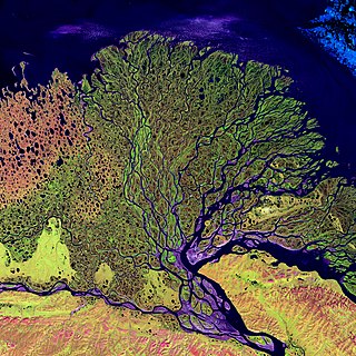
A river delta is a triangular landform created by the deposition of the sediments that are carried by the waters of a river, where the river merges with a body of slow-moving water or with a body of stagnant water. The creation of a river delta occurs at the river mouth, where the river merges into an ocean, a sea, or an estuary, into a lake, a reservoir, or into another river that cannot carry away the sediment supplied by the feeding river. Etymologically, the term river delta derives from the triangular shape (Δ) of the uppercase Greek letter delta. In hydrology, the dimensions of a river delta are determined by the balance between the watershed processes that supply sediment and the watershed processes that redistribute, sequester, and export the supplied sediment into the receiving basin.

In physical geography and hydrology, a channel is a landform on which a relatively narrow body of water is situated, such as a river, river delta or strait. While channel typically refers to a natural formation, the cognate term canal denotes a similar artificial structure.
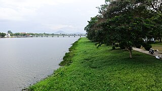
In geography, a bank is the land alongside a body of water. Different structures are referred to as banks in different fields of geography, as follows.
The European Geosciences Union (EGU) is a non-profit international union in the fields of Earth, planetary, and space sciences whose vision is to "realise a sustainable and just future for humanity and for the planet". The organisation has headquarters in Munich, Germany. Membership is open to individuals who are professionally engaged in or associated with these fields and related studies, including students, early career scientists and retired seniors.

A riparian zone or riparian area is the interface between land and a river or stream. In some regions, the terms riparian woodland, riparian forest, riparian buffer zone, riparian corridor, and riparian strip are used to characterize a riparian zone. The word riparian is derived from Latin ripa, meaning "river bank".
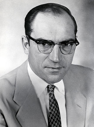
Luna Bergere Leopold was a leading U.S. geomorphologist and hydrologist, and son of Aldo Leopold. He received a B.S. in civil engineering from the University of Wisconsin in 1936; an M.S. in physics-meteorology from the University of California, Los Angeles in 1944; and a Ph.D. in geology from Harvard University in 1950.
In hydrology, a debouch is a place where runoff from a small, confined space discharges into a larger, broader body of water. The word is derived from the French verb déboucher, which means "to unblock, to clear". The term also has a military usage.
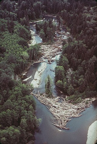
A log jam is a naturally occurring phenomenon characterized by a dense accumulation of tree trunks and pieces of large wood across a vast section of a river, stream, or lake. Log jams in rivers and streams often span the entirety of the water's surface from bank to bank. Log jams form when trees floating in the water become entangled with other trees floating in the water or become snagged on rocks, large woody debris, or other objects anchored underwater. They can build up slowly over months or years, or they can happen instantaneously when large numbers of trees are swept into the water after natural disasters. A notable example caused by a natural disaster is the log jam that occurred in Spirit Lake following a landslide triggered by the eruption of Mount St. Helens. Unless they are dismantled by natural causes or humans, log jams can grow quickly, as more wood arriving from upstream becomes entangled in the mass. Log jams can persist for many decades, as is the case with the log jam in Spirit Lake.
The British Society for Geomorphology (BSG), incorporating the British Geomorphological Research Group (BGRG), is the professional organisation for British geomorphologists and provides a community and services for those involved in teaching or research in geomorphology, both in the UK and overseas. The society’s journal, Earth Surface Processes and Landforms is published by Wiley-Blackwell and online access is available free to members. The society is affiliated with the Royal Geographical Society as an affiliated research group and with the Geological Society of London as a specialist group.

Bank erosion is the wearing away of the banks of a stream or river. This is distinguished from erosion of the bed of the watercourse, which is referred to as scour.

Riparian-zone restoration is the ecological restoration of riparian-zonehabitats of streams, rivers, springs, lakes, floodplains, and other hydrologic ecologies. A riparian zone or riparian area is the interface between land and a river or stream. Riparian is also the proper nomenclature for one of the fifteen terrestrial biomes of the earth; the habitats of plant and animal communities along the margins and river banks are called riparian vegetation, characterized by aquatic plants and animals that favor them. Riparian zones are significant in ecology, environmental management, and civil engineering because of their role in soil conservation, their habitat biodiversity, and the influence they have on fauna and aquatic ecosystems, including grassland, woodland, wetland or sub-surface features such as water tables. In some regions the terms riparian woodland, riparian forest, riparian buffer zone, or riparian strip are used to characterize a riparian zone.
Markley Gordon Wolman was an American geographer, son of Abel Wolman. He was born in Baltimore, Maryland. He attended Haverford College before being drafted into the U.S. Navy during World War II. After the war, he returned to Baltimore and graduated from the Johns Hopkins University in 1949 with a degree in Geography. He earned a doctorate in Geology from Harvard University in 1953.

Hydrogeomorphology has been defined as “an interdisciplinary science that focuses on the interaction and linkage of hydrologic processes with landforms or earth materials and the interaction of geomorphic processes with surface and subsurface water in temporal and spatial dimensions.” The term 'hydro-geomorphology’ designates the study of landforms caused by the action of water. By this definition hydro-geomorphology is inseparable part of geomorphology moreover fluvial geomorphology, because water is one of the most important agents in forming and shaping of landforms. From the groundwater point of view integration of geological, structural and hydrological data with hydro-geomorphologic data is very much useful in finding out the groundwater potential zones with fruitful results. The science relating to the geographical, geological, and hydrological aspects of water bodies and to changes to these aspects in response to low variations and to natural and human caused events, such as heavy rainfall or channel straightening is the hydro-geomorphology.

Murugesu Sivapalan is an Australian-American engineer and hydrologist of Sri Lankan Tamil origin and a world leader in the area of catchment hydrology. He is currently the Chester and Helen Siess Endowed Professor of Civil and Environmental Engineering, and professor of Geography & Geographic Information Science, at the University of Illinois, Urbana-Champaign. Sivapalan is widely recognized for his fundamental research on scale issues in hydrological modeling, his leadership of global initiatives aimed at hydrologic predictions in ungauged basins, and for his role in launching the new sub-field of socio-hydrology.
River incision is the narrow erosion caused by a river or stream that is far from its base level. River incision is common after tectonic uplift of the landscape. Incision by multiple rivers result in a dissected landscape, for example a dissected plateau. River incision is the natural process by which a river cuts downward into its bed, deepening the active channel. Though it is a natural process, it can be accelerated rapidly by human factors including land use changes such as timber harvest, mining, agriculture, and road and dam construction. The rate of incision is a function of basal shear-stress. Shear stress is increased by factors such as sediment in the water, which increase its density. Shear stress is proportional to water mass, gravity, and WSS:
Daniel Roy Parsons is the Pro-Vice-Chancellor for Research and Innovation at Loughborough University and holds the Personal Title of Professor in Geosciences. He was the founding Director of the Energy and Environment Institute (2017–2022) and a professor of process sedimentology at the University of Hull from 2011 to 2022. He is also a visiting professor at the University of Illinois (USA) and Can Tho University (Vietnam). He obtained his PhD at the University of Sheffield in 2004. Parsons is known for his work on flow processes and sediment transport in rivers, coasts and estuaries, and the deep sea. This includes work addressing flood hazard and risk, as well as internationally leading work detailing turbidity currents and associated hazards in the deep sea. Parsons also researches the leakage and transport of plastics in rivers, coasts and estuaries and as part of the Huxley debate at the 2018 British Science Festival he claimed that the most significant marker for the Anthropocene age may be the fossilisation of plastic debris such as formed in plastiglomerate. Parsons is currently a member of the Natural Environment Research Council Research Committee. Parsons has recently completed a major research programme funded via a European Research Council Consolidator Award exploring the evolution of stickiness and its impact of morphodynamic and sedimentary processes. He is presently President of Division for Geomorphology of the European Geosciences Union and a Commissioner on the Yorkshire and Humber Climate Commission, chairing the Research and Evidence Panel.
Ellen E. Wohl is an American fluvial geomorphologist. She is professor of geology with the Warner College of Natural Resources at Colorado State University.

Renzo Rosso is an Italian hydrologist recognized for his contributions to water resources and environmental engineering.
References
- ↑ Gurnell, Angela (1 November 2018). "Twenty-five years of progress in physical geography: a personal view of its antecedents and trajectory". Geography. 103 (3): 122–136. doi:10.1080/00167487.2018.12094049. ISSN 0016-7487. S2CID 198422755.
- ↑ "Penn State Engineering: Civil and Environmental Engineering Events". www.cee.psu.edu. Retrieved 1 March 2022.
- 1 2 "Penn State Engineering: Civil and Environmental Engineering Events". www.cee.psu.edu. Retrieved 16 January 2022.
- ↑ "Angela Gurnell - Research Portal, King's College, London". kclpure.kcl.ac.uk. Retrieved 16 January 2022.
- 1 2 "Angela Gurnell". www.qmul.ac.uk. Retrieved 16 January 2022.
- ↑ "Angela M. Gurnell". European Geosciences Union (EGU). Retrieved 16 January 2022.
- ↑ "Urban River Survey". urbanriversurvey.org. Retrieved 16 January 2022.
- ↑ "Modular River Survey". modularriversurvey.org. Retrieved 16 January 2022.
- ↑ "Royal Geographical Society - Medals and awards". www.rgs.org. Retrieved 16 January 2022.
- ↑ "Angela Gurnell (2012) | British Society for Geomorphology". www.geomorphology.org.uk. Retrieved 16 January 2022.
- ↑ "Alfred Wegener Medal & Honorary Membership". European Geosciences Union (EGU). Retrieved 16 January 2022.
| International | |
|---|---|
| National | |
| Academics | |
| Other | |