Modes of transport in Mozambique include rail, road, water, and air. There are rail links serving principal cities and connecting the country with Malawi, Zimbabwe and South Africa. There are over 30,000km of roads, but much of the network is unpaved.
Nampula is a province of northern Mozambique. It has an area of 79,010 km² and a population of 3,985,613. Nampula is the capital of the province.

Angoche Island is a small continental island in the district of same name, Mozambique. Being a coastal island its main source of income was the illegal shipment of slaves, which allowed for the enrichment of the aristocratic classes of the Nyapakho clan. It was not taken by the Portuguese until 1913, thanks to the brave resistance of the sultan, particularly Ibrahim Iussuf. His nephew, who was the commander-in-chief of a 30.000 men army took over power and opposed with tenacity the Portuguese until 1890. By then, Farlah, the last sultan resumed the war against the Portuguese until he was captured in a battle in 1910 and deported to East Timor where he died in prison. The small island is subject to cyclones; Cyclone Huda in particular is remembered, and so permanent habitation has not been possible. Angoche is the largest producer of cashew and shrimps in Mozambique.

Angoche is a city of Nampula Province in Mozambique. The city was named António Enes until 1976, after the 19th-century Portuguese journalist and colonial administrator, António José Enes. In administrative terms, since 1998, the city is also a municipality.

The Island of Mozambique lies off northern Mozambique, between the Mozambique Channel and Mossuril Bay, and is part of Nampula Province. Prior to 1898, it was the capital of colonial Portuguese East Africa. With its rich history and sandy beaches, the Island of Mozambique is a UNESCO World Heritage site and one of Mozambique's fastest growing tourist destinations. It has a permanent population of approximately 14,000 people and is served by nearby Lumbo Airport on the Nampula mainland.

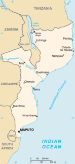
The provinces of Mozambique are divided into 128 districts. The districts are listed below, by province:

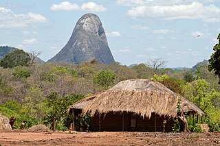
Cuamba is a city and district of Niassa Province in Mozambique, lying north west of Mount Namuli. Before independence the town was known as Nova Freixo.
The Koti language, or Ekoti, is a Bantu language spoken in Mozambique by about 64,200 people. Koti is spoken on Koti Island and is also the major language of Angoche, the capital of the district with the same name in the province of Nampula.
The Angoche Sultanate was established in 1485 along an archipelago off the Northern Mozambique coastline. Centered on the cities of Angoche and Moma, the sultanate also had a number of vassal territories surrounding them. They were finally removed from power by the Portuguese colonial government in 1910.

Islam in Mozambique is the religion of approximatel 60% of the total population. The vast majority of Mozambican Muslims are Sunni belonging to Shafi school of jurisprudence, although some Ismaili Shiite Muslims are also registered. The Muslims consists primarily of indigenous Mozambicans, citizens of South Asian descent, and a very small number of North African and Middle Eastern immigrants.
Bazaruto Island Airport is an airport serving Bazaruto Island, Bazaruto Archipelago, Mozambique, and the Bazaruto National Park.
Nampula Airport is an airport in Nampula, Mozambique. In the northeastern part of Mozambique, with 2 paved runways.
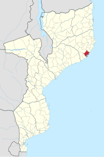
Angoche District is a district of Nampula Province in north-eastern Mozambique. The principal town is Angoche.
Cuamba Airport is an airport serving Cuamba, a city in the Niassa Province in Mozambique. The airport is in the southern part of the city and is a major airport in the province of Niassa in central Mozambique.
Mueda Airport is an airport serving Mueda, Cabo Delgado Province, Mozambique.
Stone Town is a town situated towards the northern end of the Island of Mozambique. Stone Town is grander than Macuti town in the southern part of the island.


