
The Amu Darya is a major river in Central Asia and Afghanistan. Rising in the Pamir Mountains, north of the Hindu Kush, the Amu Darya is formed by the confluence of the Vakhsh and Panj rivers, in the Tigrovaya Balka Nature Reserve on the border between Afghanistan and Tajikistan, and flows from there north-westwards into the southern remnants of the Aral Sea. In its upper course, the river forms part of Afghanistan's northern border with Tajikistan, Uzbekistan, and Turkmenistan. In ancient history, the river was regarded as the boundary of Greater Iran with "Turan", which roughly corresponded to present-day Central Asia.
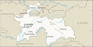
Tajikistan is nestled between Kyrgyzstan and Uzbekistan to the north and west, China to the east, and Afghanistan to the south. Mountains cover 93 percent of Tajikistan's surface area. The two principal ranges, the Pamir Mountains and the Alay Mountains, give rise to many glacier-fed streams and rivers, which have been used to irrigate farmlands since ancient times. Central Asia's other major mountain range, the Tian Shan, skirts northern Tajikistan. Mountainous terrain separates Tajikistan's two population centers, which are in the lowlands of the southern and northern sections of the country. Especially in areas of intensive agricultural and industrial activity, the Soviet Union's natural resource utilization policies left independent Tajikistan with a legacy of environmental problems.

A valley is an elongated low area often running between hills or mountains, which will typically contain a river or stream running from one end to the other. Most valleys are formed by erosion of the land surface by rivers or streams over a very long period of time. Some valleys are formed through erosion by glacial ice. These glaciers may remain present in valleys in high mountain or polar areas. At lower latitudes and altitudes, these glacially formed valleys may have been created or enlarged during ice ages but now are ice-free and occupied by streams or rivers. In desert areas, valleys may be entirely dry or carry a watercourse only rarely. In areas of limestone bedrock, dry valleys may also result from drainage taking place underground rather than at the surface. Rift valleys arise principally from earth movements, rather than erosion. Many different types of valley are described by geographers, using terms that may be global in use or else applied only locally.

The headwaters of a river or stream is the farthest place in that river or stream from its estuary or downstream confluence with another river, as measured along the course of the river. It is also known as a river's source.

The McMurdo Dry Valleys are a row of largely snow-free valleys in Antarctica, located within Victoria Land west of McMurdo Sound. The Dry Valleys experience extremely low humidity and surrounding mountains prevent the flow of ice from nearby glaciers. The rocks here are granites and gneisses, and glacial tills dot this bedrock landscape, with loose gravel covering the ground. It is one of the driest places on Earth and has not seen rain for nearly 2 million years.

Palula and also known as Ashreti (Aćharêtâʹ) or Dangarikwar, is a Dardic language spoken by approximately 10,000 people in the valleys of Ashret and Biori, as well as in the village of Puri in the Shishi valley and at least by a portion of the population in the village Kalkatak, in the Chitral District of Khyber Pakhtunkhwa province of Pakistan. It is closely related to the Sawi language of Afghanistan and to Kalkoti, which is spoken in Dir District. The area where Palula is spoken includes 35°28′N71°53′E.
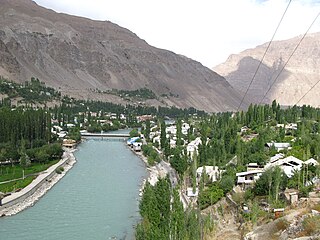
The Gunt is a river in the south of Tajikistan. It is 296 kilometres (184 mi) long and has a basin area of 13,700 square kilometres (5,300 sq mi). Its source, Lake Yashilkul, is situated at the edge of the Alichur Pamir, a high plateau or pamir at an elevation of 3720m. The city of Khorog is located at the confluence of the Gunt with the Panj. See Gorno-Badakhshan Autonomous Region for surrounding area.
Nadia Anjuman was a poet from Afghanistan.

Goshta District is located in the northeast of Nangarhar Province, Afghanistan and borders Durand Line between Afghanistan and Pakistan. The district's population is Pashtun and was estimated at 160,000 in 2002, of whom 30,000 were children under 12. The district is within the heartland of the Mohmand tribe of Pashtuns. The district centre is the village of Goshta, on the Kabul River.

Balochistan is an arid desert and mountainous region in South and Western Asia. It comprises the Pakistani province of Balochistan, the Iranian province of Sistan and Baluchestan, and the southern areas of Afghanistan, including Nimruz, Helmand and Kandahar provinces. Balochistan borders the Pashtunistan region to the north, Sindh and Punjab to the east, and Persian regions to the west. South of its southern coastline, including the Makran Coast, are the Arabian Sea and the Gulf of Oman.
The following lists events that happened during 1946 in Afghanistan.

The Panjshir River flows through the Panjshir Valley in northeastern Afghanistan, 150 kilometres (93 mi) north of Kabul. Its main tributary is the Ghorband River which flows from the Parwan Province and joins the Panjshir River 10 km east of Charikar in Bagram District. The Panjshir River takes its source near the Anjuman Pass and flows southward through the Hindu Kush and joins the Kabul River at the town of Surobi. A dam was built on the Panjshir River near Surobi in the 1950s to supply water from the Panjshir River to the Kabul River. There is just one permanent bridge on Panjshir river that provides access to Bagram Airport. On 12 July 2018, there was a flood in Panjshir valley in which ten people were killed.

Liv Glacier is a steep valley glacier, 64 km (40 mi) long, emerging from the Antarctic Plateau just southeast of Barnum Peak and draining north through the Queen Maud Mountains to enter Ross Ice Shelf between Mayer Crags and Duncan Mountains. It was discovered in 1911 by Roald Amundsen, who named it for the daughter of Fridtjof Nansen. The airway above the Liv Glacier was used by the monoplane Floyd Bennett in 1929 as the route for the first journey to the South Pole by air.
Anjum, Anjom, Anjuman or Anjoman, meaning a gathering or society, may refer to:
The Anjuman Valley is a valley in Afghanistan. It connects to the Munjan valley some twelve miles above Sari Sang. The valley is drained by the Anjuman stream.

Anjuman, also written Anjoman, is the name of a village in Badakhshan Province, Afghanistan. It lies within the Anjuman Valley, about 18 miles from the mouth of the valley. Another village, Anjuman-i-Khurd, lies close by. Around the turn of the 21st century, the village had 90 occupied residences, primarily Tajiks. The grazing in the area was good, and the inhabitants were a peaceful lot, and relatively poorly armed.
Anjuman-i-Khurd is a village in Afghanistan. It lies within the Anjuman Valley, about 18 miles from the mouth of the valley. Another village, Anjuman, lies close by. Around the turn of the 20th century, the village had 30 occupied residences, primarily Tajiks. The grazing in the area was good, and the inhabitants were a peaceful lot, and relatively poorly armed. Khurd and Kalan Persian language word which means small and Big respectively when two villages have same name then it is distinguished as Kalan means Big and Khurd means Small with Village Name.
Baloch nationalism asserts that the Baloch people, an ethnic group native to Pakistan, Iran and Afghanistan are a distinct nation. The movement propagates the view that Muslims are not a nation and that ethnic loyalty must surpass religious loyalty. This is the opposite of the concept behind the creation of Pakistan, a concept challenged by both the 1971 civil war in East Pakistan and the discrimination many Muhajir people have historically faced within Pakistan.
The Anjuman Pass is a mountain pass in the Hindu Kush in Afghanistan. It connects the Panjshir Valley to the south to Badakhshan to the north, which is the most north-easterly province of Afghanistan. The climate in this area is usually cold with snow, The roads are narrow and slippery.
