
La Croft is a census-designated place (CDP) in Columbiana County, Ohio, United States. The population was 1,144 at the 2010 census.
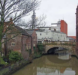
The River Foss is an improved river in North Yorkshire, England, and a tributary of the River Ouse. It rises in the Foss Crooks woods near Oulston reservoir close to the village of Yearsley and runs south through the Vale of York to the Ouse. The name most likely comes from the Latin word Fossa, meaning ditch and is mentioned in the Domesday Book. The York district was settled by Norwegian and Danish people, so parts of the place names could be old Norse. Referring to the etymological dictionary "Etymologisk ordbog", ISBN 82-905-2016-6 dealing with the common Danish and Norwegian languages – roots of words and the original meaning. The old Norse word Fos (waterfall) meaning impetuous. The River Foss was dammed, and even though the elevation to the river Ouse is small, a waterfall was formed. This may have led to the name Fos, and later changed to Foss.
Weetwood is an area between Headingley and Meanwood in north-west Leeds, West Yorkshire, England. It is bounded on the north by the A6120, on the west by the A660, on the east by Meanwood Beck and to the south by Hollin Lane. Weetwood Lane runs north and south through it.

Park & Arbourthorne ward—which includes the districts of Arbourthorne, Gleadless, and Norfolk Park—is one of the 28 electoral wards in City of Sheffield, England. It is located in the southeastern part of the city and covers an area of 1.74 square miles (4.5 km2). The population of this ward in 2001 was 17,500 people in 7,800 households. The ward population at the 2011 Census was 19,133. It is one of the five wards that form the Sheffield Heeley parliamentary constituency.
North Lochs,, an area in eastern Lewis, Outer Hebrides, Scotland, is named for the many lochans which dot the landscape. Because of its largely undulating and rocky terrain, it is sparsely populated apart from flat ground near the coast. Its communities support traditional crofting and fishing.

The River Darwen is a river running through the towns of Darwen and Blackburn in Lancashire which eventually joins the River Ribble at Walton le Dale. Here the river runs to the south of Preston on its way to the Ribble Estuary on the west coast of northern England.
Warrington North is a parliamentary constituency represented in the House of Commons of the Parliament of the United Kingdom. It elects one Member of Parliament (MP) by the first past the post system of election. The current MP is Helen Jones of the Labour Party — the constituency has always been a safe Labour seat.

Cleethorpes is a constituency created in 1997, represented in the House of Commons of the UK Parliament since 2010 by Martin Vickers of the Conservative Party.

Cherry Hill is one of the southernmost neighborhoods in Baltimore, Maryland.

The European route E 22 is one of the longest European routes. It has a length of about 5,320 km (3,310 mi). Many of the E-roads have been extended into Asia since the year 2000; the E 22 was extended on 24 June 2002.

Tranby Croft is a large Grade II listed Victorian country house and estate at Anlaby, near Hull in the East Riding of Yorkshire, England. The house is now the co-educational, independent day school, Hull Collegiate School.
Leigh Rural District was, from 1894 to 1933, a rural district of the administrative county of Lancashire, in northwest England. It spanned a rural area outyling from the town Leigh.

St Vincent’s Church is a disused Roman Catholic church situated on Solly Street at its junction with Hollis Croft in the centre of the City of Sheffield, South Yorkshire.

Croft is an unincorporated community in El Dorado County, California. It is located 1.5 miles (2.4 km) south of Caldor, at an elevation of 4,518 feet.

Reaseheath College is a land-based further education and higher education college, mainly located on the outskirts of Nantwich in Cheshire, England.
White Wells is a spa bath situated on Ilkley Moor in West Yorkshire, England. It was built in c.1700 as an open air spa bath, later baths were enclosed and a single plunge pool survives today inside the White Wells Spa Cottage.
Bitsihuitsos Butte is a summit in the U.S. state of Arizona.

Croft and Huncote Quarry is a 35.3 hectare geological Site of Special Scientific Interest north of Croft in Leicestershire. It is a Geological Conservation Review site.

Croft Hill is a two hectare biological Site of Special Scientific Interest north of Croft in Leicestershire.
Croft Pasture is a 6.2 hectare biological Site of Special Scientific Interest on the outskirts of Croft in Leicestershire. Most of the site, totalling 5.8 hectares, is owned and managed by the Leicestershire and Rutland Wildlife Trust.

