
Ballsbridge is an affluent neighbourhood of the city of Dublin, the capital of Ireland. The area is largely situated north and west of a three-arch stone bridge across the River Dodder, on the south side of the city. The sign on the bridge still proclaims it as "Ball's Bridge", in recognition of the fact that the original bridge on that location was built and owned by the Ball family, a well-known Dublin merchant family in the 1500s and the 1600s. The current bridge was built in 1791.

Newcastle is a small seaside resort town in County Down, Northern Ireland, which had a population of 8,298 at the 2021 Census. It lies by the Irish Sea at the foot of Slieve Donard, the highest of the Mourne Mountains. Newcastle is known for its sandy beach, forests, and mountains. The town lies within the Newry, Mourne and Down District.
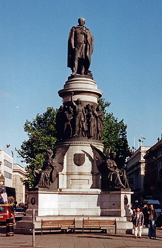
O'Connell Street is a street in the centre of Dublin, Ireland, running north from the River Liffey. It connects the O'Connell Bridge to the south with Parnell Street to the north and is roughly split into two sections bisected by Henry Street. The Luas tram system runs along the street.

Drumcondra is a residential area and inner suburb on the Northside of Dublin, Ireland. It is administered by Dublin City Council. The River Tolka and the Royal Canal flow through the area.
Ranelagh is an affluent residential area and urban village on the Southside of Dublin, Ireland in the postal district of Dublin 6.
Celbridge is a town and townland on the River Liffey in County Kildare, Ireland. It is 23 km (14 mi) west of Dublin. Both a local centre and a commuter town within the Greater Dublin Area, it is located at the intersection of the R403 and R405 regional roads. As of the 2022 census, Celbridge was the third largest town in County Kildare by population, with 20,601 residents.

Howth is an affluent peninsular village and outer suburb of Dublin, Ireland. The district as a whole occupies the greater part of the peninsula of Howth Head, which forms the northern boundary of Dublin Bay, and includes the island of Ireland's Eye, which holds multiple natural protection designations.

Fairview is an inner coastal suburb of Dublin in Ireland, in the jurisdiction of Dublin City Council and in the city's D03 postal district. Part of the area forms Fairview Park, a recreational amenity laid out on land reclaimed from the sea.
Phibsborough, also spelled Phibsboro, is a mixed commercial and residential neighbourhood on the Northside of Dublin, Ireland.

Ballybough is an inner city district of northeast Dublin city, Ireland. Adjacent areas include the North Strand and Clonliffe.

East Wall is an inner city area of the Northside of Dublin, Ireland. Built on reclaimed ground in the 1820s, the area is also 30 minutes walk from Dublin's main thoroughfare, O'Connell Street.
Sir Rory O'Moore, also known Sir Roger O'Moore or O'More or Sir Roger Moore, was an Irish landowner, and is most notable for being one of the four principal organisers of the Irish Rebellion of 1641.

The River Tolka, also once spelled Tolga, is one of Dublin's three main rivers, flowing from County Meath to Fingal within the old County Dublin, and through the north of Dublin city, Ireland. By flow of water, the Tolka is the second largest river in Dublin, following the Liffey, but runs more slowly than the Dodder.

Baggot Street is a street in Dublin, Ireland.

Parnell Street is a street in Dublin, Ireland, which runs from Capel Street in the west to Gardiner Street and Mountjoy Square in the east. It is at the north end of O'Connell Street, where it forms the south side of Parnell Square.

North Strand Road is a street in the Northside of Dublin, Ireland. It links the city centre from Connolly Station to Fairview by road.

The Dublin quays refers to the two roadways and quays that run along the north and south banks of the River Liffey in Dublin, Ireland. The stretches of the two continuous streets have several different names. However, all but two of the names share the same "quay" designation. The quays have played an important part in Dublin's history.

Clanbrassil Street is a street in Dublin south of the city centre. It runs from Robert Emmet Bridge on the Grand Canal to New Street. It is served by several bus routes. It is divided into Clanbrassil Street Upper and Clanbrassil Street Lower.
Richard Vincent Comerford, known generally as Vincent Comerford, is a professor of Irish history at the National University of Ireland, Maynooth who retired in January 2010. Comerford graduated from St. Patrick's College, (NUI) Maynooth, BA(1965) and MA (1971), followed by a PhD from Trinity College Dublin in 1977. He was appointed Professor of Modern History at Maynooth in 1989.

The R105 road is a regional road in north Dublin, Ireland. It travels from the city centre to Howth, and loops at both ends; the road fully encircles Howth Head. Along the way, the road passes through Fairview, the western end of Clontarf, Killester, Raheny, the coastal edge of Kilbarrack and Sutton. Its biggest component is Howth Road.

