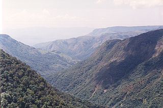
In hydrology and sewage collection and disposal, antecedent moisture is the relative wetness or dryness of a watershed or sanitary sewershed. Antecedent moisture conditions change continuously and can have a very significant effect on the flow responses in these systems during wet weather. The effect is evident in most hydrologic systems including stormwater runoff and sanitary sewers with inflow and infiltration. Many modeling and analysis challenges that are created by antecedent moisture conditions are evident within combined sewers and separate sanitary sewer systems.
The word antecedent simply means "preceding conditions". Combining the terms "antecedent" and "moisture" together means "preceding wetness conditions". Antecedent moisture is the relative wetness or dryness of a sewershed, which changes continuously and can have a very significant effect on the flow responses in these systems during wet weather. Antecedent moisture conditions are high when there has been a lot of recent rainfall and the ground is moist. Antecedent moisture conditions are low when there has been little rainfall and the ground becomes dry.
Hydrologic basis
Rainfall/runoff relationship are well defined within the field of hydrology. Surface runoff in hydrologic systems is generally conceptualized as occurring from pervious and impervious areas. It is the pervious runoff that is affected by antecedent moisture conditions, as runoff from impervious surfaces such as roads, sidewalks, and roofs will not be significantly affected by preceding moisture levels. Pervious surfaces (such as fields, woods, grassed areas, and open areas) are highly affected by antecedent moisture conditions, as they will produce a greater rate of runoff when they are wet than when they are dry.
Rainfall-dependent inflow and infiltration (RDII) into sewer systems is highly affected by antecedent moisture conditions, and these effects can be more complex than the rainfall/runoff relationships for surface water. The travel paths for RDII entering the sewer system are more complex than surface water runoff, because the transport mechanisms include both surface runoff and subsurface transportation. This adds additional complexities to the hydrologic effects and antecedent moisture effects such as the saturation levels of the soils in the subsurface, groundwater levels, and subsurface hydraulics.
Antecedent moisture conditions are highly affected by preceding rainfall levels. However, preceding rainfall is not the only condition that affects antecedent moisture, and many other variables in the hydrologic process can have a significant impact. For example, air temperature, wind speed, and humidity levels affect evaporation rates, which can significantly change antecedent moisture conditions. Additional effects may include evapotranspiration, presence or absence of tree canopy, and snow and ice melting effects.
Traditional analysis approaches
Traditional approaches for analyzing antecedent moisture effects rely on physically-based models derived from first principles, such as the principles of energy, momentum, and continuity, which rely on measurements of many parameters for input and simulation. These include programs such as the Storm Water Management Model, Mouse RDII, or other rainfall/runoff simulation programs. These models are frequently calibrated to a specific antecedent moisture condition observed during a single storm. Fitting data from several storms that occurred during various antecedent moisture conditions requires modifying the model parameters and recalibrating the model. At the end of this process, the modeler is left with several models, each of which can fit a specific storm that occurring during a specific antecedent moisture condition, but none of which are capable of simultaneously fitting all of the data. This is the challenge of using event-based models with traditional approaches: it requires the user to select a particular antecedent moisture condition for design simulations.
Some modeling approaches—such as the Hydrologic Simulation Program - Fortran (HSPF) or the Stanford Watershed Model developed by Crawford and Linsley (1966)—attempt to address antecedent moisture conditions through a complex physically based representation of the transport paths of water on the surface and in the subsurface. These tools have their place in researching and studying the various complexities associated with hydrologic transport processes. However, the great number of parameters in these models, the difficulty of measuring the many parameters, and the sensitivity of the model output to slight variations in the parameters makes using these models to simulate antecedent moisture in sewer systems challenging. Occam's razor provides evidence of these challenges from a systems perspective.
Data-based approaches
An alternative approach for modeling antecedent moisture is to start from measurements of the behavior of the system and the external influences (inputs to the system) and try to determine a mathematical relation between them without going into the details of what is actually happening inside the system. This approach is called system identification. System identification is applied in several fields beyond engineering, ranging from economics to astronomy, and it also comes under other names (such as inverse modeling, time series analysis, and empirical physical modeling). System identification is a general term to describe mathematical tools and algorithms that build dynamical models from measured data. A dynamical model in this context is a mathematical description of the dynamic behavior of a system or process. In many cases, a so-called white-box model based on first principles (e.g., a model for a physical process from Newton's laws of motion) will be overly complex and possibly even impossible to obtain in reasonable time, due to the complex nature of many systems and processes.
Data-based approaches based on system identification, such as the H2Ometrics antecedent moisture model, have been applied to hydrologic modeling for simulating antecedent moisture effects on wet weather events in sanitary collection systems. This modeling approach differs from traditional techniques because it is based on system identification and is guided by system observations (i.e. data) and mathematical routines are used to generate the correct model structure, rather than physically based first principles. This is in contrast to assuming that the correct model is known beforehand, as is typically the case for modeling within civil engineering. This technique allows information within the observations to guide the modeling algorithms so that only the relevant and observed dynamics are present in the model structure. The resulting models are not black box, but are grey box models that have parameters and structure that tie directly to physical understanding and interpretation.
Related Research Articles
Hydrology is the scientific study of the movement, distribution, and management of water on Earth and other planets, including the water cycle, water resources, and environmental watershed sustainability. A practitioner of hydrology is called a hydrologist. Hydrologists are scientists studying earth or environmental science, civil or environmental engineering, and physical geography. Using various analytical methods and scientific techniques, they collect and analyze data to help solve water related problems such as environmental preservation, natural disasters, and water management.
A hydrograph is a graph showing the rate of flow (discharge) versus time past a specific point in a river, channel, or conduit carrying flow. The rate of flow is typically expressed in cubic meters or cubic feet per second . It can also refer to a graph showing the volume of water reaching a particular outfall, or location in a sewerage network. Graphs are commonly used in the design of sewerage, more specifically, the design of surface water sewerage systems and combined sewers.
Infiltration is the process by which water on the ground surface enters the soil. It is commonly used in both hydrology and soil sciences. The infiltration capacity is defined as the maximum rate of infiltration. It is most often measured in meters per day but can also be measured in other units of distance over time if necessary. The infiltration capacity decreases as the soil moisture content of soils surface layers increases. If the precipitation rate exceeds the infiltration rate, runoff will usually occur unless there is some physical barrier.
The United States Environmental Protection Agency (EPA) Storm Water Management Model is a dynamic rainfall–runoff–subsurface runoff simulation model used for single-event to long-term (continuous) simulation of the surface/subsurface hydrology quantity and quality from primarily urban/suburban areas. It can simulate the Rainfall- runoff, runoff, evaporation, infiltration and groundwater connection for roots, streets, grassed areas, rain gardens and ditches and pipes, for example. The hydrology component of SWMM operates on a collection of subcatchment areas divided into impervious and pervious areas with and without depression storage to predict runoff and pollutant loads from precipitation, evaporation and infiltration losses from each of the subcatchment. Besides, low impact development (LID) and best management practice areas on the subcatchment can be modeled to reduce the impervious and pervious runoff. The routing or hydraulics section of SWMM transports this water and possible associated water quality constituents through a system of closed pipes, open channels, storage/treatment devices, ponds, storages, pumps, orifices, weirs, outlets, outfalls and other regulators. SWMM tracks the quantity and quality of the flow generated within each subcatchment, and the flow rate, flow depth, and quality of water in each pipe and channel during a simulation period composed of multiple fixed or variable time steps. The water quality constituents such as water quality constituents can be simulated from buildup on the subcatchments through washoff to a hydraulic network with optional first order decay and linked pollutant removal, best management practice and low-impact development removal and treatment can be simulated at selected storage nodes. SWMM is one of the hydrology transport models which the EPA and other agencies have applied widely throughout North America and through consultants and universities throughout the world. The latest update notes and new features can be found on the EPA website in the download section. Recently added in November 2015 were the EPA SWMM 5.1 Hydrology Manual and in 2016 the EPA SWMM 5.1 Hydraulic Manual and EPA SWMM 5.1 Water Quality Volume (III) + Errata”
Rain gardens, also called bioretention facilities, are one of a variety of practices designed to treat polluted stormwater runoff. Rain gardens are designed landscape sites that reduce the flow rate, total quantity, and pollutant load of runoff from impervious urban areas like roofs, driveways, walkways,and parking lots, and compacted lawn areas. Rain gardens rely on plants and natural or engineered soil medium to retain stormwater and increase the lag time of infiltration, while remediating and filtering pollutants carried by urban runoff. Rain gardens provide a method to reuse and optimize any rain that falls, reducing or avoiding the need for additional irrigation. A benefit of planting rain gardens is the consequential decrease in ambient air and water temperature, a mitigation that is especially effective in urban areas containing an abundance of impervious surfaces that absorb heat in a phenomenon known as the heat-island effect.
First flush is the initial surface runoff of a rainstorm. During this phase, water pollution entering storm drains in areas with high proportions of impervious surfaces is typically more concentrated compared to the remainder of the storm. Consequently, these high concentrations of urban runoff result in high levels of pollutants discharged from storm sewers to surface waters.
Surface runoff is the flow of water occurring on the ground surface when excess rainwater, stormwater, meltwater, or other sources, can no longer sufficiently rapidly infiltrate in the soil. This can occur when the soil is saturated by water to its full capacity, and that the rain arrives more quickly than the soil can absorb it. Surface runoff often occurs because impervious areas do not allow water to soak into the ground. Surface runoff is a major component of the water cycle. It is the primary agent of soil erosion by water. The land area producing runoff that drains to a common point is called a drainage basin.
In hydrology, a water balance equation can be used to describe the flow of water in and out of a system. A system can be one of several hydrological domains, such as a column of soil or a drainage basin. Water balance can also refer to the ways in which an organism maintains water in dry or hot conditions. It is often discussed in reference to plants or arthropods, which have a variety of water retention mechanisms, including a lipid waxy coating that has limited permeability.
The runoff curve number is an empirical parameter used in hydrology for predicting direct runoff or infiltration from rainfall excess. The curve number method was developed by the USDA Natural Resources Conservation Service, which was formerly called the Soil Conservation Service or SCS — the number is still popularly known as a "SCS runoff curve number" in the literature. The runoff curve number was developed from an empirical analysis of runoff from small catchments and hillslope plots monitored by the USDA. It is widely used and is an efficient method for determining the approximate amount of direct runoff from a rainfall event in a particular area.
An hydrological transport model is a mathematical model used to simulate the flow of rivers, streams, groundwater movement or drainage front displacement, and calculate water quality parameters. These models generally came into use in the 1960s and 1970s when demand for numerical forecasting of water quality and drainage was driven by environmental legislation, and at a similar time widespread access to significant computer power became available. Much of the original model development took place in the United States and United Kingdom, but today these models are refined and used worldwide.
The HBV hydrology model, or Hydrologiska Byråns Vattenbalansavdelning model, is a computer simulation used to analyze river discharge and water pollution. Developed originally for use in Scandinavia, this hydrological transport model has also been applied in a large number of catchments on most continents.
Sanitary sewer overflow (SSO) is a condition in which untreated sewage is discharged from a sanitary sewer into the environment prior to reaching sewage treatment facilities. When caused by rainfall it is also known as wet weather overflow. It is primarily meaningful in developed countries, which have extensive treatment facilities. Frequent causes of SSO spills include:
Groundwater models are computer models of groundwater flow systems, and are used by hydrogeologists. Groundwater models are used to simulate and predict aquifer conditions.
GSSHA is a two-dimensional, physically based watershed model developed by the Engineer Research and Development Center of the United States Army Corps of Engineers. It simulates surface water and groundwater hydrology, erosion and sediment transport. The GSSHA model is used for hydraulic engineering and research, and is on the Federal Emergency Management Agency (FEMA) list of hydrologic models accepted for use in the national flood insurance program for flood hydrograph estimation. Input is best prepared by the Watershed Modeling System interface, which effectively links the model with geographic information systems (GIS).
The following outline is provided as an overview of and topical guide to hydrology:
Vflo is a commercially available, physics-based distributed hydrologic model generated by Vieux & Associates, Inc. Vflo uses radar rainfall data for hydrologic input to simulate distributed runoff. Vflo employs GIS maps for parameterization via a desktop interface. The model is suited for distributed hydrologic forecasting in post-analysis and in continuous operations. Vflo output is in the form of hydrographs at selected drainage network grids, as well as distributed runoff maps covering the watershed. Model applications include civil infrastructure operations and maintenance, stormwater prediction and emergency management, continuous and short-term surface water runoff, recharge estimation, soil moisture monitoring, land use planning, water quality monitoring, and water resources management.
DPHM-RS is a semi-distributed hydrologic model developed at University of Alberta, Canada.
In hydrology, routing is a technique used to predict the changes in shape of a hydrograph as water moves through a river channel or a reservoir. In flood forecasting, hydrologists may want to know how a short burst of intense rain in an area upstream of a city will change as it reaches the city. Routing can be used to determine whether the pulse of rain reaches the city as a deluge or a trickle.
Low-impact development (LID) is a term used in Canada and the United States to describe a land planning and engineering design approach to manage stormwater runoff as part of green infrastructure. LID emphasizes conservation and use of on-site natural features to protect water quality. This approach implements engineered small-scale hydrologic controls to replicate the pre-development hydrologic regime of watersheds through infiltrating, filtering, storing, evaporating, and detaining runoff close to its source. Green infrastructure investments are one approach that often yields multiple benefits and builds city resilience.
The flash flood guidance system (FFGS) was designed and developed by the Hydrologic Research Center a non-profit public-benefit corporation located in of San Diego, CA, US, for use by meteorological and hydrologic forecasters throughout the world. The primary purpose of the FFGS is to provide operational forecasters and disaster management agencies with real-time informational guidance products pertaining to the threat of small-scale flash flooding throughout a specified region. The FFGS provides the necessary products to support the development of warnings for flash floods from rainfall events through the use of remote-sensed precipitation and hydrologic models. The FFGS outputs are made available to users to support their analysis of weather-related events that can initiate flash floods and then to make a rapid evaluation of the potential for a flash flood at a location. To assess the threat of a local flash flood, the FFGS is designed to allow product adjustments based on the forecaster's experience with local conditions, incorporation of other information and any last minute local observations or local observer reports. The system supports evaluations of the threat of flash flooding over hourly to six-hourly time scales for stream basins that range in size from 25 to 200 km2 in size. Important technical elements of the flash flood guidance system are the development and use of a bias-corrected radar and/or satellite precipitation estimate field and the use of land-surface hydrologic modeling. The system then provides information on rainfall and hydrologic response, the two important factors in determining the potential for a flash flood. The system is based on the concept of flash flood guidance and flash flood threat. Both indices provide the user with the information needed to evaluate the potential for a flash flood, including assessing the uncertainty associated with the data.
This page is based on this Wikipedia article Text is available under the CC BY-SA 4.0 license; additional terms may apply. Images, videos and audio are available under their respective licenses.