A lieutenant governor, lieutenant-governor, or vice governor is a high officer of state, whose precise role and rank vary by jurisdiction. Often a lieutenant governor is the deputy, or lieutenant, to or ranked under a governor — a "second-in-command", rather like deputy governor. In Canadian provinces and in the Dutch Caribbean, the lieutenant governor is the representative of the monarch in that jurisdiction, and thus outranks the head of government, but for practical purposes has virtually no power.

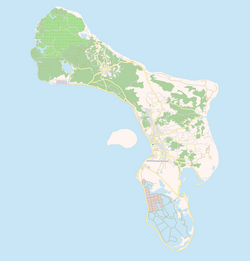
Bonaire is a Dutch island in the Leeward Antilles in the Caribbean Sea. Its capital is the port of Kralendijk, on the west (leeward) coast of the island. Aruba, Bonaire and Curaçao form the ABC islands, 80 km off the coast of Venezuela. Unlike much of the Caribbean region, the ABC islands lie outside Hurricane Alley. The islands have an arid climate that attracts visitors seeking warm, sunny weather all year round. Bonaire is a popular snorkeling and scuba diving destination because of its multiple shore diving sites and easy access to the island's fringing reefs.

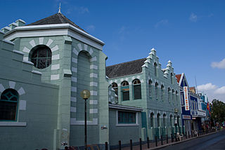
Kralendijk is the capital city and main port of the island of Bonaire in the Caribbean Netherlands. The language spoken in the town is Papiamentu, but Dutch and English are widely used. As of 2017, the town had a population of 10,620. In Papiamentu, the town is often called Playa or "beach".

Flamingo International Airport, also called Bonaire International Airport, is an international airport located near Kralendijk on the island of Bonaire in the Caribbean Netherlands. It was once the hub for BonaireExel and CuraçaoExel before they were rebranded as Dutch Antilles Express, and served as a secondary hub for Dutch Antilles Express and Insel Air. The airport is the fourth largest in the Dutch Caribbean, after Queen Beatrix International Airport on Aruba, Princess Juliana International Airport on Sint Maarten and Curaçao International Airport on Curaçao and is now the largest airport in the Caribbean Netherlands, with F. D. Roosevelt Airport in Sint Eustatius being the second largest and Juancho E. Yrausquin Airport in Saba being the smallest.

The flag of Bonaire, adopted in 11 December 1981, represents the Dutch island in the Caribbean Netherlands. Bonaire commemorates Flag Day on September 6 annually, the traditional date Europeans first arrived on the island. The professional vexillologist Whitney Smith was involved in developing Bonaire's flag.
Divishon Honor – Bonaire or known as Kampionato is the top association football league in Bonaire, a special municipality of the Netherlands in the Caribbean. The top two teams in this competition competed in the Netherlands Antilles Championship until the dissolution of the Netherlands Antilles in 2010.

SV Vitesse is a football team from Antriòl, Kralendijk on Bonaire in the Caribbean Netherlands, playing at the top level.

Rincon is one of the two towns in Bonaire, a special municipality of the Kingdom of the Netherlands. It is situated in the north of the island in an inland valley.
The Roman Catholic Diocese of Willemstad is a diocese of the Latin Church of the Roman Catholic Church in the Caribbean. The diocese encompasses the territory of the Kingdom of the Netherlands in the Caribbean: the countries Aruba, Curaçao, Sint Maarten and the islands Bonaire, St. Eustatius, Saba. The cathedra is in the city of Curaçao. The diocese is a suffragan of the Archdiocese of Port of Spain, and a member of the Antilles Episcopal Conference.

The Caribbean Netherlands are the three public bodies of the Netherlands that are located in the Caribbean Sea. They consist of the islands of Bonaire, Sint Eustatius and Saba, although the term "Caribbean Netherlands" is sometimes used to refer to all of the islands in the Dutch Caribbean. In legislation, the three islands are also known as Bonaire, Sint Eustatius and Saba or the BES islands. The islands are currently classified as public bodies in the Netherlands and as overseas countries and territories of the European Union; thus, European Union law does not automatically apply.

The Bonaire national football team is the national football team of the Caribbean island of Bonaire, a public body of the Netherlands. It is under the control of the Bonaire Football Federation. It became a member of the CFU and an associate member of CONCACAF on 19 April 2013. after which it became a full CONCACAF member on 10 June 2014 The team can participate in the CONCACAF Gold Cup and Caribbean Cup because of their membership in the confederation and sub-confederation. However, Bonaire is not a member of FIFA and therefore can not compete in the FIFA World Cup or other FIFA events.

The St. Bernard Church is a religious building belonging to the Catholic Church and is located in the city of Kralendijk the capital of the Caribbean island of Bonaire, a territory in the Caribbean Dutch organized as a special municipality of the Kingdom of the Netherlands in the Antilles.
The Our Lady of Coromoto Church also known as the Parish of Our Lady of Coromoto is a religious building belonging to the Catholic Church and is located in the town of Antriol on the island of Bonaire, a dependent territory of the Kingdom of the Netherlands in the Caribbean Sea.
Mamita Fox is a Curaçao-born nurse, activist, artist and writer who lives in Bonaire. Her autobiography, written in Papiamento, is an important addition to works written in Creole languages. A well-known radio personality on the island, Fox became a vocal opponent to health care law changes by the Netherlands and how they impacted citizens of the former Netherlands Antilles. Her activism led to a change in the way health care was administered.

Scholengemeenschap Bonaire (SGB) is a secondary school in Bonaire with multiple campuses in the capital Kralendijk; one for Liseo Boneriano Bovenbouw, and another for Liseo Boneriano Onderbouw, VMBO Vakcollege, and SLP - Pro.

The COVID-19 pandemic in Bonaire is part of the ongoing global viral pandemic of coronavirus disease 2019 (COVID-19), which was confirmed to have reached the Dutch Caribbean island of Bonaire on 16 April 2020. On 28 April, all cases recovered. On 14 July, two new cases were discovered. On 13 August, all cases recovered.
Time in the Kingdom of the Netherlands is denoted by Central European Time (CET) during the winter as standard time in the Netherlands, which is one hour ahead of coordinated universal time (UTC+01:00), and Central European Summer Time (CEST) during the summer as daylight saving time, which is two hours ahead of coordinated universal time (UTC+02:00). The Caribbean Netherlands – which consist of the islands of Bonaire, Sint Eustatius and Saba – all observe Atlantic Standard Time (AST) year-round, which is four hours behind coordinated universal time (UTC−04:00).

Fort Orange is a military fortification in Kralendijk, Bonaire. Originally built in 1639 as a nameless fort by the Dutch West India Company, it is the oldest structure on the island of Bonaire. The fort has never been used for its intended purpose. In 1816, it was rebuilt and named Fort Orange. The current lighthouse was built in 1932.