Anukkur also known as Anupuram is a village located in the southern part of India. It is also a gram panchayat located in Veppanthatti taluk, Perambalur district and state of Tamil Nadu.
Anukkur also known as Anupuram is a village located in the southern part of India. It is also a gram panchayat located in Veppanthatti taluk, Perambalur district and state of Tamil Nadu.
According to the 2011 census, The population of Anukkur is 3093 with 1131 households. 48.4% of them are male and 51.6% of them are female.[ citation needed ]
People who lives in Anukkur are mostly Hindus. Most of them speak Tamil. 0.1% of the population is from scheduled tribe, 16.5% of the population is from scheduled caste and rest of the population is backward and most backward community.
The Literacy rate of Anukkur is 57.5% and 57% of them are working population. Most of them are farmers and some of them are daily wages.

Tenkasi is a town and headquarters of the Tenkasi district in Indian state of Tamil Nadu. Tenkasi District was formed as the 33rd District of Tamil Nadu
Other Backward Class is a category of population, created by the Government of India in year 1991 besides the existing categories (General Class, Scheduled Castes and Scheduled Tribes) to refer to castes and communities which were educationally or socially under developed at that time.
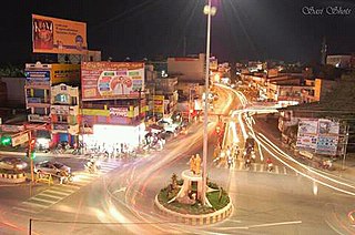
Dharmapuri is a city in the north western part of Tamil Nadu, India. It serves as the administrative headquarters of Dharmapuri district which is the first district created in Tamil Nadu after the independence of India by splitting it from then Salem district on 2 October 1965. The city is located at 50 km from Krishnagiri, 69 km from Salem, 90 km from Hosur, 117 km from Thiruvannamalai, 126 km from Bangalore and Erode, 181 km from Tiruppur, 200 km from Coimbatore and Tiruchirappalli, 300 km from Madurai and the state capital Chennai. It is located between latitudes N 11 47’ and 12 33’ and longitudes E 77 02’ and 78 40’. It is one of the leading major cultivator and producer of mango in the state along with Krishnagiri often referred as Mango Capital of India.
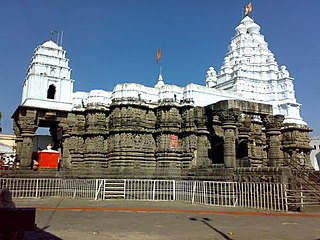
Hingoli district is an administrative district in the state of Maharashtra in India. The district is headquartered at Hingoli. The district occupies an area of 4,526 km2 and has a population of 11,77,345 of which 15.60% were urban. Hingoli was actually known as the Nizams military base as it was bordered with Vidharbha. In that era military troops, hospitals, veterinary hospital were in operation from Hingoli. Being a military base the city was one of the important and famous places of the Hyderabad state. One of the twelve Jyotirlinga shrines, the Aundha Nagnath is located in Hingoli district about 25 km south-west from district headquarter.

Goalpara district is an administrative district of the Indian state of Assam.
Arakkonam is a railway town in the Indian state of Tamil Nadu, with a population of 78,395 per the census 2011. It is in the newly created Ranipet district, about 54 kilometres (34 mi) from Ranipet headquarters and about 69 kilometres (43 mi) from the state capital of Chennai. It is in the suburban area of Chennai.

Shravasti district is one of the districts of the Uttar Pradesh state of India, with Bhinga town as its district headquarters. Shravasti district is a part of Devipatan Division. According to Government of India, it is among the 121 minority concentrated districts in India. It is the fourth most backward district in India, according to the 2018 Niti Aayog ranking.

Dindori District, formerly known as Ramgarh District, is a district of Madhya Pradesh state of central India. The town of Dindori is the district headquarters. The district is part of Jabalpur Division. Total area of the district is 6,128 km2 (2,366 sq mi). It is located on the eastern part of Madhya Pradesh, bordering the state of Chhattisgarh. It is surrounded by Anuppur district to the northeast, Umaria district to the north, Jabalpur district to the west, Mandla district to the southwest and Mungeli and Kabirdham districts of Chhattisgarh to the south.

Katni district officially Murwara district is one of the 51 districts of Madhya Pradesh state in central India. The town of Katni is the district headquarters. The district is part of Jabalpur Division. The district occupies an area of 4949.59 km².
Dumri block is a CD block that forms an administrative division in the Chainpur subdivisionS of Gumla district, in the Indian state of Jharkhand.

Kalaburagi district, formerly known as Gulbarga district, is one of the 31 districts of Karnataka state in southern India. Kalaburagi city is the administrative headquarters of the district. The district is the headquarters of Kalaburagi division.

Ambur is a town and municipality in newly announced Tirupattur District, Tamil Nadu, India. It is located on the banks of the Palar River between Chennai and Bangalore. Ambur has a sizeable leather industry, and is known for its spicy biryani and for the sweet, makkhenpeda. Ambur was the site of two major military actions in the 18th Century. The first was the 1749 Battle of Ambur that opened the Second Carnatic War between the Arcot State and the Mughal Empire. In 1767, the siege of Ambur took place during the First Anglo-Mysore War, with local troops and a British force successfully resisting an attack by the Kingdom of Mysore and by the Hyderabad State.

Dindigul District is one of the 38 districts in the state of Tamil Nadu in India. Dindigul District is the largest district in Tamil Nadu by area. The district was carved out of Madurai District in 1985. It has an area of 6266.64 km2 and comprises 3 revenue divisions, 10 taluks, and 14 panchayat unions. The district is bound by Tiruppur district in the northwest, Karur district in the northeast, Tiruchirapalli district in the east, Madurai and Theni districts in the south, and Idukki district of Kerala to the west. As of 2011, the district had a population of 2,159,775 with a sex-ratio of 998 females for every 1,000 males.
Reservation is a system of affirmative action in India that provides historically disadvantaged groups representation in education, employment, government schemes, health, insurance, banking, foreign higher education, scholarships and politics. Based on provisions in the Indian Constitution, it allows the Union Government and the States and Territories of India to set reserved quotas or seats, which lower the qualifications needed in exams, job openings, university admissions, scholarships, loan approval, promotions etc. for "socially and educationally backward citizens."
Gangavalli is a panchayat town in Salem district in the state of Tamil Nadu, India.
Palacode is a panchayat town in Dharmapuri district in the Indian state of Tamil Nadu.
Virudhachalam or Vriddhachalam is a Town and taluk headquarters in Cuddalore district in the Indian state of Tamil Nadu. The ancient name of this town is Thirumudhukundram. As per the 2011 census, the town had a population of 73,585 of which 37,066 are males while 36,519 are females. Population of children in the ages of 0-6 is 7735 which is 10.51 % of the total population. The old Lord Siva temple is located in the heart of town. This is the 41st Devaram Padal Petra Siva Thiruthalam and 9th Thiruthalam in Nadu Naadu(நடுனாடு). Moovar has sung hymns in praise of Lord Siva of this temple. The temple was constructed by one of the Chola Emperors. The famous Kolanjiappar Temple is located 3 km away from the town. Both of them are situated near Cuddalore - Salem highway in Virudhachalam.
General Class/General Category/Open Category is a term used in India to denote castes whose members are on average ahead of other Indians economically and socially. Forward castes account for about 30.8% of the population based on Schedule 10 of available data from the National Sample Survey Organisation 55th (1999–2000) and National Sample Survey Organisation 61st Rounds (2004–05) Round Survey.
Uthangarai is a state assembly constituency in Tamil Nadu, India, that was formed after constituency delimitation in 2007 The seat is reserved for candidates from the Scheduled Castes. It comprises a portion. Located in Krishnagiri district, it consists of Uthangarai taluk and a portion of Pochampalli taluk. It is included in the Krishnagiri parliamentary constituency.
Santuri is a community development block that forms an administrative division in the Raghunathpur subdivision of the Purulia district in the Indian state of West Bengal.
Coordinates: 11°19′55″N78°51′50″E / 11.332°N 78.864°E
| | This article related to a location in Perambalur district, Tamil Nadu, India is a stub. You can help Wikipedia by expanding it. |