Anupgarh canal is the canal which irrigates agriculture land in the south part of Shri Ganganagar district and north west of Bikaner district of western India.
Contents

It is the main source of drinking water in this area. [1]
Anupgarh canal is the canal which irrigates agriculture land in the south part of Shri Ganganagar district and north west of Bikaner district of western India.
It is the main source of drinking water in this area. [1]
It originates near Suratgarh from Indira Gandhi Canal.
It irrigates agriculture lands of Suratgarh tehsil, Vijaynagar tehsil, Anupgarh tehsil, Ghrsana tehsil and Khajuwala tehsil, and other land.
Toba Tek Singh District is a district of Faisalabad Division in the Punjab province of Pakistan. It is located between 30°33' to 31°2' Degree north latitudes and 72°08' to 72°48' Degree longitudes. It became a separate district in 1982.

Sri Ganganagar is the northernmost city of the Indian state of Rajasthan, near the international border of India and Pakistan. It is the administrative headquarters of Sri Ganganagar district. It is named after Maharaja Shri Ganga Singh Bahadur, Maharaja of Bikaner. The city is also known as the "Food Basket of Rajasthan".

Sheikhan town is situated in Chiniot Tehsil and in District Chiniot in Punjab province of Pakistan.
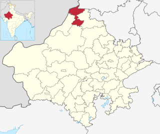
Sri Ganganagar district is the northernmost district of Rajasthan state in western India.

Suratgarh is a city and a municipality, just nearby Sri Ganganagar city in Sri Ganganagar district in the Indian state of Rajasthan. Founded by Maharaja Surat Singh. Hindi, Bagri and Rajasthani are the widely spoken languages of the city.
Vijaynagar or Vijaynagar is a town and a municipality in Anupgarh district in the Indian state of Rajasthan.

Khajuwala is a town in the Bikaner district of Rajasthan, India. It is located near the Indo-Pakistan border and is situated around 100 kilometres (62 mi) from the district headquarters Bikaner. It is an Municipality with several villages under its administration. It produces a lot of raw cotton and wheat. Indira Gandhi Canal has brought about development of this area. It is a big agro products market in Bikaner district. Earlier its name was Beriyawali. It is also seat in Rajasthan legislative assembly. The current elected Member of Legislative assembly (MLA) from Khajuwala is Govind ram meghwal (INC). Khajuwala has recently been given a status of Municipality.
Leti is a village in the Punjab Province of Pakistan. The name is derived from a shallow water stream.

Rawla Mandi is a town in Rawla Mandi tehsil of Anupgarh district of Rajasthan, India. It is located on Gharsana-Khajuwala road,50 kms from district headquarter Anupgarh and 24 km away from Gharsana and 180 km from the Sri Ganganagar. The state capital Jaipur is 480 km away, and national capital New Delhi is 600 km away. It is 33 km from Khajuwala and 122 km from Bikaner. It is 30 km far from Indo-Pak(India-Pakistan) border. Rawla mandi known as 8PSD (B) gram panchayt. Rawla Gaon Also located in West of rawla mandi
Ramsinghpur also known as 59 Gb, is a small town located in Anupgarh tehsil and is a sub-tehsil in district of Anupgarh in Rajasthan of India.
Sri Vijaynagar Tehsil is the one of Seven tehsils of Anupgarh district of Rajasthan, India. It is located in the Eastern part of District Anupgarh. It is bordered by Anoopgarh tehsil in the west, by Raisinghnagar tehsil in the north, Suratgarh tehsil in the east, and Bikaner district in the south.
Padampur tehsil is one of the Ten tehsils of the Ganganagar district in the north western Indian state of Rajasthan. It is located in the northern area of the district. The city of Padampur is the headquarters of the tehsil. Its north border touches Ganganagar tehsil. It has borders in the east with Sadulshahar Tehsil and with Hanumangarh district. The south-east border is with Suratgarh tehsil, the west by Raisinghnagar tehsil and north-west with Karanpur tehsil. The Village Delwan lies 5 kilometres (3.1 mi) to the north-west.
Suratgarh tehsil is the largest administrative region (tehsil) in the Ganganagar district. It is bordered on the north by Padampur tehsil, on the west by Vijaynagar tehsil and Raisinghnagar tehsil, on the south by Bikaner district, and on the east by Hanumangarh district. Suratgarh is a Brand.
Raisinghnagar Tehsil is a tehsil of Anupgarh district, Rajasthan, India. It is in the central-western area of the district. Raisinghnagar is the headquarters of the tehsil. Sameja and Muklawa are Sub Tehsil in Raisinghnagar
365 Head, also called 2 KLD is a village in Anupgarh district of Rajasthan, India. It is located in the south-western region of Gharsana Tehsil, 74 kilometers from Anupgarh district headquarter and 198.2 kilometers from Ganganagar. 365 Head has gram panchayat status. It is named after the 365 R.D. of Anoopgarh branch canal.
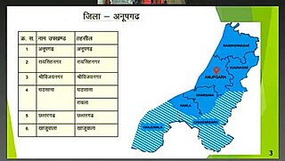
Anupgarh Tehsil is the one of Seven tehsils of Anupgarh district in Rajasthan, India. The tehsil headquarters are located at the town of Anupgarh.
Sri Gurusar Modia is a village in the Indian state of Rajasthan situated near borders of Rajasthan, Haryana and Punjab states and the international border of India and Pakistan. This village is located in the tehsil Suratgarh of district Sriganganagar. Suratgarh, once known as Sodhal was believed to be surrounded by the confluence of Saraswati and Drishyati rivers but now the land is a deserted one lying amidst the expanse of The great Indian Thar desert. Suratgarh is famous for its agriculture, air force and army base stations, largest thermal power plant of Rajasthan and largest radio station of Rajasthan called as "Cotton City Channel". Sri Gurusar Modia came into limelight when a controversial self-proclaimed saint and spiritual leader Gurmeet Ram Rahim Singh was believed to be incarnated there and crowned to the throne of Dera Sacha Sauda at Sirsa in 1991. With setting up of Shah Satnam Schools for both boys and girls, super speciality hospitals etc. this village became nationwide popular
Wakura is a village located in the Ganderbal district of Jammu and Kashmir, India. In 2013 it was given tehsil status, with the tehsil headquarters located in Lar, 13 km away.
Chhatargarh is a tehsil in the Anupgarh district of Rajasthan, India. Most of the area is covered by agricultural land and is irrigated by IGNL canal.
Bagar, also Bagad (बागड़) a term meaning the "dry country", is a region refers in north-western India and eastern parts of current Pakistan bordering north Rajathan, India where Bagri language is spoken inhabited by Ethenic Bagri people and was characterised by Sandy tracks and shifting sand dunes which are now irrigated by canals.