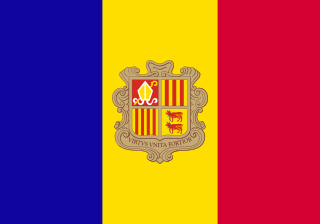
Andorra is a small, landlocked country in southwestern Europe, located in the eastern Pyrenees mountain range and bordered by Spain and France. With an area of 468 km², it is the sixth smallest country in Europe and also the largest of the European microstates.
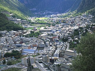
Andorra la Vella is the capital of the Principality of Andorra. It is located high in the east Pyrenees, between France and Spain. It is also the name of the parish that surrounds the capital.

La Seu d'Urgell is a town located in the Catalan Pyrenees in Spain. La Seu d'Urgell is also the capital of the comarca Alt Urgell, head of the judicial district of la Seu d'Urgell and the seat of Bishop of Urgell, one of the Andorra co-princes. It is in the district of Alt Pirineu i Aran, and is the town with the most inhabitants, having 17.4% of the district population. La Seu d'Urgell and Puigcerdà together have 30% of the population of the area.
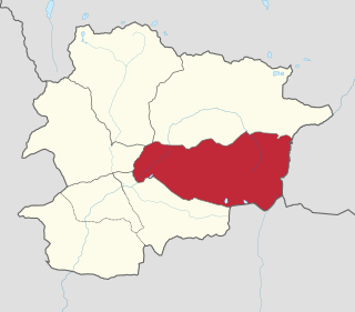
Encamp is one of the parishes of Andorra, located on the Valira d'Orient river. It is also the name of the main town in the parish. Other settlements include Vila, El Pas de la Casa, Grau Roig, el Tremat, la Mosquera and Les Bons. As of 2004, it has about 11,800 inhabitants. The center of the municipality lies 1,300 metres (4,270 ft) above sea level. The highest mountain in the parish is Pic dels Pessons.

Ordino is the most northerly parish in the Principality of Andorra. It's mostly the main area of Valira del Nord or Valira d'Ordino river valley. Ordino is also the name of the main town of the parish. Other settlements in the parish are El Serrat, Ansalonga, Sornàs, La Cortinada, Llorts, Segudet, Arans, Les Salines and Arcalís. It is home to the Sorteny National Park, the largest nature area of Andorra. It has a population of 4,858, as of 2017. The town preserves a vast medieval center, mainly linked to the culture of the country.

Gran Via de les Corts Catalanes, more simply known as Gran Via[ˈɡɾam ˈbi.ə], is one of Barcelona's major avenues. With a length of 13.1 km (8.1 mi), it is the longest street in Catalonia and the 2nd longest in Spain, after Gran Vía de la Manga, in La Manga del Mar Menor, but is the one with more street numbers in Spain.

Plaça d'Espanya or Plaza de España in Spanish, is one of Barcelona's most important squares, built on the occasion of the 1929 International Exhibition, held at the foot of Montjuïc, in the Sants-Montjuïc district.

Carrer del Carme is a street in central Barcelona, Catalonia, Spain, located in the Raval neighbourhood of the Ciutat Vella district. It is part of the recently revamped commercial area of Raval. This street contains the main offices of Institut d'Estudis Catalans and Societat Catalana de Geografia, as well as the Catholic church Església de Betlem, built in the Baroque style, and the public library Biblioteca Sant Pau-Santa Creu, based in the former building of Hospital de la Santa Creu, which was moved to El Guinardó. The street is notable for being mentioned on the first page of Jean Genet's novel The Thief's Journal.

Sant Antoni is a neighborhood in the Eixample district of Barcelona, Catalonia (Spain). Its non-official centre, the marketplace of the same name—designed by Antoni Rovira i Trias and built between 1872 and 1882—is one of the oldest and most popular in the city, especially with the secondhand book stalls that surround the building Sunday mornings. It is bordered by the neighbourhoods of the L'Antiga Esquerra de l'Eixample, the Raval, and Poble Sec. The streets of Sant Antoni follow the grid pattern prevalent in all of Eixample, except for a central thoroughfare, the Avinguda de Mistral, built on the site of an important medieval road which led out of Barcelona. Another well-known landmark of Sant Antoni is the bar called Els Tres Tombs, right next to the market.

Torà is a town and municipality in the North East of the comarca (county) of Segarra, in the province of Lleida, Catalonia, Spain. The urban structure of the center has retained most of its original design, with narrow, twisting streets and blocks formed by rows of attached buildings. The Medieval town grew around a castle or fortified place. A particular trait of the fortified origin of the town is the presence of a number of portals to allow several streets their pass through defensive barriers formed by the rows of buildings of the town and its walls. Torà is some 10 kilometers northeast from the more populated Guissona, a neighbor town that has experienced an important economic development in the last half century parallel to an unprecedented demographic growth sped up in the recent years.

Santa Maria de Gerri is a monastery in Gerri de la Sal, in the comarca of Pallars Sobirà, Catalonia, Spain, situated on the shores of the Noguera Pallaresa river.

Catalunya en Miniatura is miniature park inaugurated in 1983 in Torrelles de Llobregat, 17 km from Barcelona. With 60.000 square meters, 35.000 of them devoted to the scale models, it is one of the largest miniature parks in the world, and the largest of the 14 miniature building exhibitions present in Europe. It displays 147 models of palaces, churches, bridges and other buildings from Catalonia and Mallorca and it includes all the major works by the renowned architect Antoni Gaudí.
The Cultural Heritage of Andorra is an organization in Andorra which protects national buildings and monuments considered of cultural and historical value.
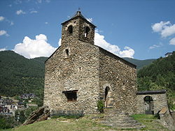
Església de Sant Climent de Pal is a church located in Pal, La Massana Parish, Andorra. It is a heritage property registered in the Cultural Heritage of Andorra. It was built in the 11th or 12th century and then again in the 17th or 18th century.

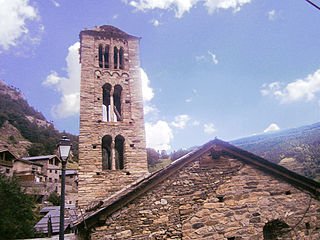
Església de Sant Iscle i Santa Victòria is a church located on Plaça del Poble in La Massana, Andorra. It is a heritage property registered in the Cultural Heritage of Andorra. It was built in the 17th century.
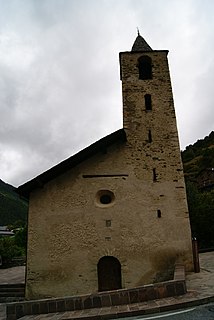
Església de Sant Joan de Sispony is a church located in Sispony, La Massana Parish, Andorra. It is a heritage property registered in the Cultural Heritage of Andorra. It was built in the 17th century.
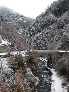
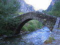
Pont d'Anyós is a bridge located in La Massana Parish, Andorra. It is a heritage property registered in the Cultural Heritage of Andorra. It was built in 1950-52.