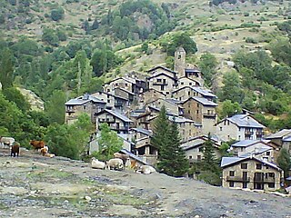
Juberri

Last updated
Juberri
Village
Andorra relief location map.jpg
Red pog.svg
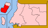
Juberri
Location in Andorra
Coordinates: 42°26′24″N1°30′24″E / 42.44000°N 1.50667°E / 42.44000; 1.50667
CountryFlag of Andorra.svg  Andorra
Parish Sant Julià de Lòria
Elevation 1,803 m (5,915 ft)
Population (2010) [1]
  Total 183

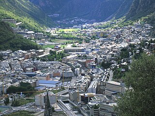
Juberri (Catalan pronunciation:  [ʒuˈβɛri] ) or Juverri is a village in Andorra, located in the south of the country near the Spanish border, above the main CG-1 road between Andorra la Vella and la Seu d'Urgell in Catalonia, Spain. It is part of the parish of Sant Julià de Lòria.

Andorra European microstate between France and Spain

Andorra, officially the Principality of Andorra, also called the Principality of the Valleys of Andorra, is a sovereign landlocked microstate on the Iberian Peninsula, in the eastern Pyrenees, bordering France to the north and Spain to the south. Believed to have been created by Charlemagne, Andorra was ruled by the Count of Urgell until 988, when it was transferred to the Roman Catholic Diocese of Urgell, and the present principality was formed by a charter in 1278. It is known as a principality as it is a diarchy headed by two Princes: the Catholic Bishop of Urgell in Catalonia, Spain, and the President of France.

Spain Kingdom in Southwest Europe

Spain, officially the Kingdom of Spain, is a country mostly located in Europe. Its continental European territory is situated on the Iberian Peninsula. Its territory also includes two archipelagoes: the Canary Islands off the coast of Africa, and the Balearic Islands in the Mediterranean Sea. The African enclaves of Ceuta, Melilla, and Peñón de Vélez de la Gomera make Spain the only European country to have a physical border with an African country (Morocco). Several small islands in the Alboran Sea are also part of Spanish territory. The country's mainland is bordered to the south and east by the Mediterranean Sea except for a small land boundary with Gibraltar; to the north and northeast by France, Andorra, and the Bay of Biscay; and to the west and northwest by Portugal and the Atlantic Ocean.

La Seu dUrgell Municipality in Catalonia, Spain

La Seu d'Urgell is a town located in the Catalan Pyrenees in Spain. La Seu d'Urgell is also the capital of the comarca Alt Urgell, head of the judicial district of la Seu d'Urgell and the seat of Bishop of Urgell, one of the Andorra co-princes. It is in the district of Alt Pirineu i Aran, and is the town with the most inhabitants, having 17.4% of the district population. La Seu d'Urgell and Puigcerdà together have 30% of the population of the area.

Related Research Articles

Geography of Andorra Jorginho

Andorra is a small, landlocked country in southwestern Europe, located in the eastern Pyrenees mountain range and bordered by Spain and France. With an area of 468 km², it is the sixth smallest country in Europe and also the largest of the European microstates.

Andorra la Vella Capital city and parish in Andorra

Andorra la Vella is the capital of the Principality of Andorra. It is located high in the east Pyrenees, between France and Spain. It is also the name of the parish that surrounds the capital.

Andorra is a landlocked country in Europe, whose transport infrastructure is largely road-based.

Encamp Place in Andorra

Encamp is one of the parishes of Andorra, located on the Valira d'Orient river. It is also the name of the main town in the parish. Other settlements include Vila, El Pas de la Casa, Grau Roig, el Tremat, la Mosquera and Les Bons. As of 2004, it has about 11,800 inhabitants. The center of the municipality lies 1,300 metres (4,270 ft) above sea level. The highest mountain in the parish is Pic dels Pessons.

General Council (Andorra) parliament of Andorra

The General Council is the unicameral parliament of Andorra. It is sometimes referred to as the General Council of the Valleys because it was the historical name and to distinguish it from similarly named bodies in the Val d'Aran and in France.

Bioko Sur Province in Luba, Equatorial Guinea

Bioko Sur is a province of Equatorial Guinea. Its capital is Luba. It occupies the southern part of the island of Bioko, the remainder of which is part of Bioko Norte.

Estadi Comunal dAndorra la Vella football stadium

The Estadi Comunal d'Andorra la Vella is a small football stadium in Andorra la Vella, the capital of Andorra. The stadium has a capacity of 1300.

Poliesportiu dAndorra

Poliesportiu d'Andorra, also known as Poliesportiu de Govern, is an indoor sporting arena located in Andorra la Vella, Andorra.

Os de Civís Village in Catalonia, Spain

Os de Civís is a village in the central Pyrenees mountains, in the municipality of Les Valls de Valira in Catalonia, Spain, and is located to the west of Andorra, near the villages of Aixàs and Bixessarri. Civís is the nearest Spanish village. It is the most populated village in the municipality.

La Cortinada Place in Ordino, Andorra

La Cortinada is a village in Andorra, located between the villages of Arans and Ansalonga in the parish of Ordino.

La Margineda Place in Andorra la Vella, Andorra

La Margineda is an Andorran village located in the parish of Andorra la Vella. It is noted for its 12th-century Romanesque bridge, Pont de la Margineda, which is the best preserved and largest such bridge in Andorra, being 33 metres long and 9.2 metres tall.

Chełpa Village in West Pomeranian, Poland

Chełpa is a village in the administrative district of Gmina Choszczno, within Choszczno County, West Pomeranian Voivodeship, in north-western Poland. It lies approximately 8 kilometres (5 mi) east of Choszczno and 67 km (42 mi) east of the regional capital Szczecin.

Khasala Kalan Place in Punjab, Pakistan

Khasala Kalan is a village of Rawalpindi District in the Punjab province of Pakistan. It is located at 33°26'24N 72°58'25E with an altitude of 370 meters (1217 ft) and lies south of the Rawalpindi on Adyala Road and approximately about 6 km meter ahead from adyala jail. A significant proportion of the population belong to the Araien And Rajput Families. In the Middle of Village A Tomb Of PIR QAZI ZAREEN BAIG SAHIB, A small DAM is Located Behind The Village Khasala Kalan, Very beautiful location and visiting and picnic spot.

Casa de la Vall construction

Casa de la Vall is a historical house in Andorra la Vella, Andorra. It is the headquarters of the General Council of Andorra. It lies just to the southwest of the Andorra National Library. It is a heritage property registered in the Cultural Heritage of Andorra.

Casa Felipó

Casa Felipó is a historical building in Andorra la Vella, Andorra. Built in 1948, it is located along the Avinguda de Meritxell, just to east of the Andorra National Library and the Església de Sant Esteve. It is a heritage property registered in the Cultural Heritage of Andorra.

Casa dels Russos

Casa dels Russos is a historical house in Santa Coloma d'Andorra, Andorra la Vella parish, Andorra. It is a heritage property registered in the Cultural Heritage of Andorra. Designed by Cesar Martinell it is built in a combination of Catalan Modernisme and Noucentisme styles.

Pont de la Margineda bridge in Andorra

Pont de la Margineda is a bridge located in Santa Coloma, Andorra la Vella Parish, Andorra. It is a heritage property registered in the Cultural Heritage of Andorra. It was built in the 14-15th century. The bridge spans a river called the Gran Valira. The archstones are pumice, to keep the structure light. The walls are made of granite.

Andorra–Spain border international border

The border between Andorra and Spain is in the Pyrenees between northern Spain and southern Andorra. It is 64 kilometres (40 mi) long. It is the outer border of the EU, as Andorra is not part of the EU.

Andorra–France border international border

The Andorra–France border extends for 57 km (35 mi) in southern France and northern and north-eastern Andorra.

References

  1. Population of settlements, Department of Statistics, Andorran Government, 2008.

Coordinates: 42°26′24″N1°30′24″E / 42.44000°N 1.50667°E / 42.44000; 1.50667

Geographic coordinate system Coordinate system

A geographic coordinate system is a coordinate system that enables every location on Earth to be specified by a set of numbers, letters or symbols. The coordinates are often chosen such that one of the numbers represents a vertical position and two or three of the numbers represent a horizontal position; alternatively, a geographic position may be expressed in a combined three-dimensional Cartesian vector. A common choice of coordinates is latitude, longitude and elevation. To specify a location on a plane requires a map projection.