| |
| Full name | Mito Citizens Gymnasium |
|---|---|
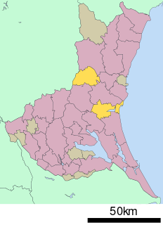
| Location | Mito, Ibaraki, Japan |
| Owner | Mito city |
| Operator | Mito city |
| Capacity | 2,736 |
| Field size | 1,794.52 sqm |
| Construction | |
| Opened | 1973 |
| Construction cost | JPY 700 million |
| Tenants | |
| Cyberdyne Ibaraki Robots | |
Aoyagi Park Citizens Gymnasium is an arena in Mito, Ibaraki, Japan. It is the home arena of the Cyberdyne Ibaraki Robots of the B.League, Japan's professional basketball league. [1]

An arena, is an enclosed area, often circular or oval-shaped, designed to showcase theatre, musical performances, or sporting events. It is composed of a large open space surrounded on most or all sides by tiered seating for spectators, and may be covered by a roof. The key feature of an arena is that the event space is the lowest point, allowing maximum visibility. Arenas are usually designed to accommodate a large number of spectators.
Mito is the capital city of Ibaraki Prefecture, in the northern Kantō region of Japan. As of September 2015, the city has an estimated population of 270,953, and a population density of 1,250 persons per km2. Its total area is 217.32 km2.

Japan is an island country in East Asia. Located in the Pacific Ocean, it lies off the eastern coast of the Asian continent and stretches from the Sea of Okhotsk in the north to the East China Sea and the Philippine Sea in the south.