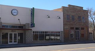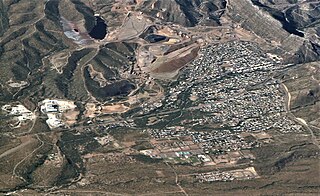
McNary is a census-designated place (CDP) in Apache and Navajo counties in the U.S. state of Arizona, on the Fort Apache Indian Reservation. The population was 528 at the 2010 census.

St. Johns is the county seat of Apache County, Arizona, United States. It is located along U.S. Route 180, mostly west of where that highway intersects with U.S. Route 191. As of the 2010 census, the population of the city was 3,480.

Apache Junction is a city in Pinal and Maricopa County, Arizona, United States. As of the 2020 census, the population was 38,499, most of whom lived in Pinal County. It is named for the junction of the Apache Trail and Old West Highway. The area where Apache Junction is located used to be known as Youngberg. Superstition Mountain, the westernmost peak of the Superstition Mountains, is to the east.

Mesa is a city in Maricopa County, Arizona, United States. It is the third-most populous city in Arizona, after Phoenix and Tucson, the 36th-most populous city in the U.S., and the most populous city that is not a county seat. The city is home to 504,258 people as of 2020. It is the most populous city in the East Valley of the Phoenix metropolitan area. It is bordered by Tempe on the west, the Salt River Pima–Maricopa Indian Community on the north, Chandler and Gilbert on the south along with Queen Creek, and Apache Junction on the east.

Holbrook is a city in Navajo County, Arizona, United States. According to the 2010 census, the population of the city was 5,053. The city is the county seat of Navajo County.

Arizona City is an unincorporated census-designated place (CDP) in southwestern Pinal County, Arizona, United States. It is located near the junction of Interstate 8 and Interstate 10 at the midpoint between Phoenix and Tucson, approximately 60 miles (97 km) from the downtown of both cities. The population was 10,475 as of the 2010 U.S. Census. It is estimated to be approximately 11,030 as of a 2017 U.S. Census estimate. Arizona City is a rural, primarily residential community that features a 48-acre man-made lake These attributes make the community a popular snowbird destination, with the population increasing by as much as 5,000 people in the winter months to reach the census figure of 11,030. Most recently after the last Census, many full-time residents have relocated to the unincorporate town.

Superior is a town in Pinal County, Arizona, United States. Superior, which is in northern Pinal County, is the oldest town in that county. According to the 2020 census, the population of the town was 2,407. Superior was founded as a mining town for the Silver King and the later Magma mines; silver was mined at first, and then transitioned to copper. Currently, exploitation of the huge Resolution Copper deposit is being explored.
KVVA-FM is a commercial radio station licensed to Sun Lakes, Arizona, serving the Phoenix metropolitan area. The station is owned by Entravision Communications, with studios near Sky Harbor Airport.

Chinle High School is a public high school in Chinle, an unincorporated area of Apache County, Arizona, United States. The school is the only high school in the Chinle Unified School District, and all of the district's elementary and middle schools feed into it. Chinle High School serves several unincorporated areas in Apache County, including Chinle, Cottonwood, Del Muerto, Lukachukai, Many Farms, Nazlini, Rough Rock, Sehili, Tsaile, and small portions of Round Rock and Sawmill. The areas the school serves are within the Navajo Nation.

The Apache Railway is an Arizona short-line railroad that operates from a connection with the BNSF Railway at Holbrook to the Snowflake Mill near Snowflake, Arizona, 38 miles (61 km). The APA was acquired by Catalyst Paper from Abitibi Consolidated in 2008. The Snowflake paper mill shut down permanently on September 30, 2012. In late 2015, the railway was purchased out of bankruptcy by a group including Aztec Land & Cattle Company and Midwest Poultry Producers, L.P., thereby avoiding a shutdown and scrappage of the line. The railway continues to operate, and its revenues are driven primarily by car repair and storage. The railway's freight revenues have not yet recovered from the shutdown of the Snowflake paper mill then owned by Catalyst, although efforts to enhance them continue.

State Route 88 is a long state highway in the U.S. state of Arizona. It runs from U.S. Route 60 in Apache Junction through desert terrain to SR 188 near Roosevelt Dam. Following the Salt River for much of its length, the section east of Tortilla Flat is known as the Apache Trail and is part of the National Forest Scenic Byway system. The Apache Trail was built in the mid-1920s, and the number 88 was assigned in 1927. An eastern extension of State Route 88 to Globe, Arizona was redesignated as State Route 188 on August 20, 1999.
KBSZ is a commercial radio station broadcasting a classic rock radio format. Licensed to Apache Junction, Arizona, the station is owned by 1TV.com. The studios and offices are on Broadway in Miami, Arizona.

Doug Coleman is an American politician from Apache Junction, Arizona, who served as a member of the Arizona House of Representatives from January 2013 to January 2019. He also served as mayor of Apache Junction from 1995 to 2007 and was the first mayor of the city to be re-elected by the people.
KVIT is a radio station licensed in Chandler, Arizona, United States. KVIT is licensed to the East Valley Institute of Technology. Its studios are located at EVIT's main facilities in Mesa, while the transmitter is to the south near Maricopa. The station is branded as 88.7 The Pulse.

Jack Owen Davis was an American football guard who played one season with the Denver Broncos of the American Football League (AFL). He was drafted by the Washington Redskins of the National Football League (NFL) in the fifteenth round of the 1958 NFL Draft. He first enrolled at the University of Oklahoma before transferring to the University of Arizona. Davis attended Heavener High School in Heavener, Oklahoma.
Geronimo Park was a shortlived baseball park in Apache Junction, Arizona, that was in use from 1962 until 1963. It lay vacant from 1963 until it was dismantled in 1969 after being sold to Mesa Public Schools. Its location is currently occupied by a lodge of the Loyal Order of Moose. With a view of Superstition Mountains, it was the first spring training ball park of the Houston Colt .45s.

Mary V. Riley was an Apache tribal council member who was instrumental in the economic development of the White Mountain Apache Tribe. She was the first woman to be elected to serve on the tribal council and worked toward bringing timber and tourism industries to the reservation to ensure their economic stability. She was inducted into the Arizona Women's Hall of Fame posthumously in 1988.

Apache Nitrogen Products began in 1920 as an American manufacturer of black powder based explosives. In the 1930's production transitioned to nitroglycerin-based explosives (dynamite) for the mining industry and other regional users of dynamite. The company changed its name to Apache Nitrogen Products in 1990 to reflect the shift away from Nitroglycerine dynamite to prilled Ammonium Nitrate for the mining industry, and by-products for the fertilizer industry. It occupies a historic location in Cochise County, Arizona and is one of its largest employers.

Silly Mountain, also known as "Roadside Benchmark", is a mountain in Arizona, United States, located near the city of Apache Junction. It is part of the Superstition Mountain range. The elevation of the mountain is 2,139 feet (652 m), and the prominence is 358 feet (109 m).


