Lava Beds National Monument is located in northeastern California, in Siskiyou and Modoc counties. The monument lies on the northeastern flank of Medicine Lake Volcano and has the largest total area covered by a volcano in the Cascade Range.

Mount Adams, known by some Native American tribes as Pahto or Klickitat, is a potentially active stratovolcano in the Cascade Range. Although Adams has not erupted in more than 1,000 years, it is not considered extinct. It is the second-highest mountain in the U.S. state of Washington, after Mount Rainier.

Ape Canyon is a gorge along the edge of the Plains of Abraham, on the southeast shoulder of Mount St. Helens in the state of Washington. The gorge narrows to as close as eight feet at one point. The name alludes to a reported encounter with several "apemen" in 1924, an event later incorporated into Bigfoot folklore.

Indian Heaven is a volcanic field in Skamania County in the state of Washington, in the United States. Midway between Mount St. Helens and Mount Adams, the field dates from the Pleistocene to the early Holocene epoch. It trends north to south and is dominated by six small shield volcanoes; these shields are topped by small spatter and cinder cones, and the field includes a number of subglacial volcanoes and tuyas. The northernmost peak in the field is Sawtooth Mountain and the southernmost is Red Mountain; its highest point is Lemei Rock at an elevation of 5,925 feet (1,806 m).
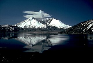
Mount St. Helens National Volcanic Monument is a U.S. National Monument that includes the area around Mount St. Helens in Washington. It was established on August 27, 1982 by U.S. President Ronald Reagan following the 1980 eruption. The 110,000 acre (445 km2) National Volcanic Monument was set aside for research, recreation, and education. Inside the Monument, the environment is left to respond naturally to the disturbance.

Silver Lake, sometimes Silverlake, is an unincorporated community in Cowlitz County, Washington, in the southwestern portion of the state. Silver Lake is located 6 miles (9.7 km) east of Castle Rock along Washington State Route 504, which is also known as the Spirit Lake Memorial Highway. The area considered Silverlake is about 6 miles (10 km) east of Interstate 5 (I-5) and is approximately 50 miles (80 km) from Portland, Oregon, to the south and Seattle about 110 miles (180 km) to the north. The closest cities to the subject property are Castle Rock, six miles (10 km) to the west, and Toutle, four miles (6 km) east.
The Mount St. Helens Creation Information Center, previously Seven Wonders Creation Museum and Seven Wonders Museum of Mount St. Helens, is a ministry, museum, and bookstore dedicated to promoting young Earth creationism. The museum is located off of I-5 at Castle Rock, Washington on Front Street near Mount St. Helens, United States. Admission is free but donations are accepted, and often accompanied by a guided tour of volcano sights.
Lava Canyon Falls drops 200 feet along the Muddy River in Skamania County, Washington.

A lava cave is any cave formed in volcanic rock, though it typically means caves formed by volcanic processes, which are more properly termed volcanic caves. Sea caves, and other sorts of erosional and crevice caves, may be formed in volcanic rocks, but through non-volcanic processes and usually long after the volcanic rock was emplaced.

The Lava River Cave near Bend, Oregon, is part of the Newberry National Volcanic Monument, which is managed by the United States Forest Service. At 5,211 feet (1,588 m) in length, the northwest section of the cave is the longest continuous lava tube in Oregon. While the cave’s discovery in 1889 was officially credited to a pioneer hunter, the presence of obsidian flakes near the cave has led archaeologists to conclude that Native Americans knew about the cave long before settlers arrived in central Oregon.

The Oregon High Desert Grotto is an American caving club, known as a grotto. It is affiliated with the National Speleological Society.

Specimen Ridge, el. 8,379 feet (2,554 m) is an approximately 8.5-mile (13.7 km) ridge along the south rim of the Lamar Valley in Yellowstone National Park. The ridge separates the Lamar Valley from Mirror Plateau. The ridge is oriented northwest to southeast from the Tower Junction area to Amethyst Mountain. The ridge is known for its abundance of amethyst, opal and petrified wood. It was referred to as Specimen Mountain by local miners and was probably named by prospectors well before 1870. The south side of the ridge is traversed by the 18.8-mile (30.3 km) Specimen Ridge Trail between Tower Junction and Soda Butte Creek. The trail passes through the Petrified Forest and over the summit of Amethyst Mountain el. 9,614 feet (2,930 m).
Cueva del Viento is the largest lava tube system in Europe, and the fifth largest in the world, behind a series of lava tubes in Hawaii. It is also considered the most complex volcanic tube in the world, due to its morphology of several levels and passages.

The Gruta das Torres, is a lava cave, a geological formation of volcanic origin formed from the flow and cooling of subterranean magma rivers. This formation is located outside the parish of Criação Velha, in the municipality of Madalena, on the western flanks of the island of Pico. The cave system formed from a series of pāhoehoe lava flows which originating from the Cabeço Bravo parasitic cone about 500 to 1500 years ago. The caves are a group of interconnected lava tubes between 0.5–22 metres (2–72 ft) width, created from both pāhoehoe and ʻaʻā types of lavas generated during different geological periods. It has a height between 1.1 and 15 metres (3.6–49 ft) and is located at an elevation of 300 metres (980 ft). With an estimated length of over 5.2 km (3.2 mi) it is the longest lava cave in the Azores. Access to the cave was managed by the Mountaineering Association. Starting in 2011, AZORINA, SA took over the management and organization of the cave.

Derrick Cave is a lava tube located in the remote northwest corner of Lake County, Oregon. The cave is approximately 1,200 feet (370 m) long. It is up to 80 feet (24 m) wide and 46 feet (14 m) high in places. It was named in honor of H.E. Derrick, a pioneer rancher with a homestead 3 miles (4.8 km) southeast of the cave. The land around the cave is managed by the United States Department of Interior, Bureau of Land Management. Derrick Cave is open to the public year-round; however, camping is no longer permitted in the cave.

Castle Creek is a tributary of the North Fork Toutle River on the flank of Mount St. Helens in Washington State. It rises about two miles (three kilometers) northwest of the crater rim and flows generally to the northwest. The outflow of Castle Lake joins the creek at the lake's north end after traveling a few hundred meters on the South Fork Castle Creek. It joins the North Fork Toutle River at 46.28302°N 122.29359°W, elevation 2,200 feet.

Windy Ridge is a ridge and eponymous Forest Highway in the Mount St. Helens National Volcanic Monument. The ridge goes between Windy Pass and Independence Pass, 1 mile (1.6 km) east of Spirit Lake. Several road guides list Windy Ridge Road (NF-99) as one of the best roads in Washington State due to its good pavement, good views, and winding "sweeper" curves enjoyable to many drivers and motorcycle riders. At the end of the road at 4,200 feet (1,300 m) elevation, at 46°15′00″N122°08′14″W above Spirit Lake, there is a viewpoint into the St. Helens crater.


