Related Research Articles

São Paulo is one of the 26 states of the Federative Republic of Brazil and is named after Saint Paul of Tarsus. A major industrial complex, the state has 21.9% of the Brazilian population and is responsible for 33.9% of Brazil's GDP. São Paulo also has the second-highest Human Development Index (HDI) and GDP per capita, the fourth-lowest infant mortality rate, the third-highest life expectancy, and the third-lowest rate of illiteracy among the federative units of Brazil. São Paulo alone is wealthier than Argentina, Uruguay, Paraguay, and Bolivia combined. São Paulo is also the world's twenty-eighth-most populous sub-national entity and the most populous sub-national entity in the Americas.

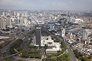
São Paulo is the most populous city in Brazil, and is the capital of the state of São Paulo, the most populous and wealthiest Brazilian state, located in the country's Southeast Region. Listed by the GaWC as an alpha global city, São Paulo is the most populous city proper in the Americas, the Western Hemisphere and the Southern Hemisphere, as well as the world's 4th largest city proper by population. Additionally, São Paulo is the largest Portuguese-speaking city in the world. It exerts strong international influences in commerce, finance, arts and entertainment. The city's name honors the Apostle, Saint Paul of Tarsus. The city's metropolitan area, the Greater São Paulo, ranks as the most populous in Brazil and the 12th most populous on Earth. The process of conurbation between the metropolitan areas around the Greater São Paulo created the São Paulo Macrometropolis, a megalopolis with more than 30 million inhabitants, one of the most populous urban agglomerations in the world.

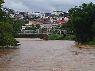
Atibaia is a Brazilian municipality in the state of São Paulo, Brazil. The name is derived from an indigenous language called Tupi, and means "healthy water river". Its name has changed over time, from the primitive Tupi word Tybaia, to Thibaia, Atubaia, Thibaya, and finally the city's modern name, Atibaia.
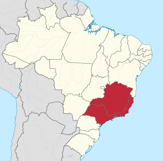
The Southeast Region of Brazil is composed of the states of Espírito Santo, Minas Gerais, Rio de Janeiro and São Paulo. It is the richest region of the country, responsible for approximately 60% of the Brazilian GDP, as São Paulo, Rio de Janeiro, and Minas Gerais are the three richest states of Brazil, the top three Brazilian states in terms of GDP. The Southeast of Brazil also has the highest GDP per capita among all Brazilian regions.
São Bernardo do Campo is a Brazilian municipality in the state of São Paulo.

The Tietê River is a Brazilian river in the state of São Paulo.

Ipiranga ([ipiˈɾɐ̃ɡɐ], from the Tupi (y, river; pirang, red) for "red river") is a historical district located in the subprefecture of the same name of São Paulo, Brazil. The name Ipiranga comes from the river (which now is a brook) of the same name located in the region, which means "red river" in a Tupí–Guaraní language. The Independence Park (Parque da Independência), where supposedly the Emperor Pedro I of Brazil proclaimed the independence of Brazil, the Paulista Museum, which exhibits classic architecture and a collection of Brazilian colonial artifacts, and the Museum of Zoology of the University of São Paulo, are also located in Ipiranga.
The Brasil Open was a tennis tournament held annually in São Paulo, Brazil. It was part of the ATP Tour 250 series, and was one of the main events in the Brazilian tennis calendar alongside ATP Tour 500 Rio Open. Since 2004, it was a part of the South American clay court circuit but was held on hard courts prior to 2004. Nicolás Almagro and Pablo Cuevas hold the record for most singles titles with three each, while in doubles the record is held by Bruno Soares with three consecutive titles from 2011 to 2013. On 15 October 2019, tournament organisers announced that the tournament was being scrapped in favour of a return to the Chile Open.

Jaçanã is a district of the city of São Paulo, Brazil. It constitutes with Tremembé the subprefecture Jaçanã-Tremembé, marking the northern boundaries of the city.

Tatuapé is a district in the subprefecture of Mooca, in São Paulo, Brazil. It is divided by a railway and the eight lane Radial Leste highway cutting the district into two, northern and southern, parts.
The Apiai-Mirim River is a river of São Paulo state in southeastern Brazil.

The Itapetininga River is a river of São Paulo state in southeastern Brazil. It is a tributary of the Paranapanema River.
The Pardo River is a river of southeastern Brazil. It originates in the state of Minas Gerais and flows to northwest, crossing the state of São Paulo and draining into Grande River.

The Piracicaba River is a river of São Paulo state in southeastern Brazil. It is a tributary of the Tietê River, which it joins in the reservoir created by Barra Bonita Dam. There is also another Piracicaba river in the state of Minas Gerais, named after the one from São Paulo state, since the early colonizers of Minas Gerais largely came from São Paulo.
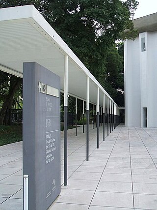
The São Paulo Museum of Image and Sound is a public museum of audio-visual works, established in 1970 and located in São Paulo, Brazil. The museum was founded as a result of a project conducted in the 1960s by Brazilian intellectuals, such as Ricardo Cravo Albin, Paulo Emílio Salles Gomes and Rudá de Andrade, with the purpose of endowing the country with institutions devoted to studying and documenting works of the new media that had been ignored by traditional museums.

The West Zone is an Administrative Zone of São Paulo, Brazil.

The Subprefecture of Butantã is one of 32 subprefectures of the city of São Paulo, Brazil. It comprises five districts: Butantã, Morumbi, Vila Sônia, Raposo Tavares, and Rio Pequeno. It hosts the main campus of University of São Paulo and the headquarters of São Paulo Futebol Clube, one of the largest teams of the city. The headquarters of Rede Bandeirantes, one of the largest media groups of Brazil, are also in this subprefecture.

Vila Prudente is one of 96 districts in the city of São Paulo, Brazil.
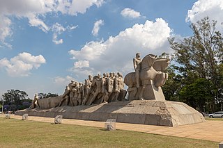
Monument to the Bandeiras is a large-scale granite sculpture by the Italian-Brazilian sculptor Victor Brecheret (1894-1955) at the entrance of Ibirapuera Park in São Paulo, Brazil. It was commissioned by the government of São Paulo in 1921 and completed in 1954. It commemorates the 17th-century bandeiras, or settling expeditions into the interior of Brazil, and the bandeirantes that participated in them. The monument is huge and in a prominent location, making it an easily identifiable part of the landscape of São Paulo.
References
Coordinates: 23°34′56″S48°36′34″W / 23.5822°S 48.6095°W