Santiago, also known as Santiago de Chile, is the capital and largest city of Chile and one of the largest cities in the Americas. It is located in the country's central valley and is the center of the Santiago Metropolitan Region, which has a population of seven million, representing 40% of Chile's total population. Most of the city is situated between 500–650 m (1,640–2,133 ft) above sea level.

Sanhattan, a portmanteau of Santiago and Manhattan, is the popular ironic sobriquet given to Santiago's upscale financial district in Chile's capital. It is located to the northeast of the metropolis, in the western end of the Las Condes commune, nestled between the Mapocho River and Américo Vespucio avenue, encompassing the El Bosque Norte and El Golf barrios. A more narrow definition places it between the intersection of Andrés Bello and Vitacura avenues down to Nueva Los Leones avenue. The central street in Sanhattan is Avenida Apoquindo.

The River Mapocho is a river in Chile. It flows from its source in the Andes mountains onto the west and divides Chile's capital Santiago in two.

Lo Barnechea is a commune located in the northeastern sector of the province of Santiago and its area corresponds to 48% of this province. Its urban boundaries are: to the north with Los Andes of the Valparaíso region, to the west with Colina, to the southwest with Vitacura and Huechuraba, to the south with Las Condes and to the east with San José de Maipo. It developed around the old rural town of Lo Barnechea. Its population is heterogeneous, as it is inhabited by high- and medium-high-income families in sectors such as La Dehesa, Los Trapenses and El Arrayán, and also by medium-low- and low-income families, mainly in the towns of Lo Barnechea, Población La Ermita and Cerro Dieciocho.

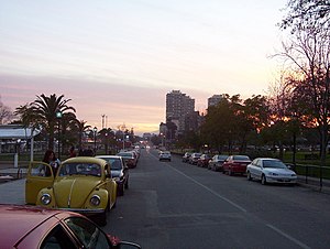
Las Condes is a commune of Chile located in Santiago Province, Santiago Metropolitan Region. The area is inhabited primarily by upper-mid- to high income families, and known in the Chilean collective consciousness as home to the country's economic elite. Most of Las Condes' commercial activity is situated along Apoquindo Avenue, which is called colloquially "Sanhattan". It belongs to the Northeastern zone of Santiago de Chile.

Estación Mapocho is a former railway station that, since 1994, has been refitted as a cultural centre that hosts many kinds of events in Santiago, Chile.

Estadio San Carlos de Apoquindo is a football stadium, in Las Condes in the metropolitan region of Santiago de Chile. It is used mostly for home matches stadium of the Chilean top club Universidad Católica which also owns the stadium. The stadium was built in 1988 and currently holds 20,000 people.
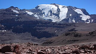
Cerro El Plomo is a mountain in the Andes near Santiago, Chile. With an elevation of 5,434 m (17,783 ft), it is the largest peak visible from Santiago on clear days. The adequate season to climb this mountain is between November and March. In spring, soil conditions have abundant snow on the approach. The best time is in January and March, where the approach is snow free, except for some specific areas, and the climate is more stable. The Incas climbed to its summit periodically in the 15th century. The first European ascent of the mountain was by Gustav Brandt and Rudolph Lucke in 1896.

El Quisco is a Chilean city and commune in San Antonio Province, Valparaíso Region. Located in the country's central coast, it serves as a popular summer resort for the population of Santiago and forms part of the Coast of Poets, a cultural space named after four world-renowned Chilean poets: Pablo Neruda, Vicente Huidobro, Violeta Parra and Nicanor Parra. El Quisco is home to La Casa de Isla Negra, the former house of Chilean poet Pablo Neruda, which is now a museum and Neruda's burial site.

The following is an alphabetical list of articles related to the Republic of Chile.

Huaca de Chena, also known as the Chena Pukara, is an Inca site on Chena Mountain, in the basin of San Bernardo, at the edge of the Calera de Tango and Maipo Province communes in Chile. Tala Canta Ilabe was the last Inca who celebrated Inti Raymi in its Ushnu.

Cerro Provincia is a mountain on the eastern side of Santiago, Chile. It is a popular climb due to its accessibility and low level of difficulty by mountaineering standards. The peak has an altitude of 2,750 metres (9,022 ft) and a climb requires an altitude gain of almost 2000 meters from the highest road-accessible point. There is a small dome-shaped refuge shelter at the summit. There are fairly well traveled paths that go to the summit and marker posts. The peak offers views of Santiago to the west, the Andes to the east, and Cerro El Plomo to the north.

The Plomo Mummy is the well preserved remains of an Incan child found on Cerro El Plomo near Santiago, Chile in 1954. It was discovered by Guillermo Chacón Carrasco, Jaime Ríos Abarca, and Luis Gerardo Ríos Barrueto. The mummy was brought to the attention of Grete Mostny at the Chilean National Museum of Natural History; she later proved instrumental in the museum's acquisition of the specimen. The Plomo Mummy was the first notable frozen mummy discovery of high-altitude Capacocha human sacrifice by the Incas, a practice called qhapaq hucha.
Hiking in Chile is characterized by a wide range of environments and climates for hikers, which largely results from Chile's unusual, ribbon-like shape, which is 4,300 kilometres long and on average 175 kilometres wide. These range from the world's driest desert, the Atacama, in the north, through a Mediterranean climate in the center, to the glaciers, fjords and lakes of Patagonia in the south.

The Apoquindo Waterfall is a waterfall in Waters of Ramon Natural Park on the east side of Santiago, Chile, near Apoquindo. It is fed by melting snow from Cerro de Ramon and Cerro Provincia. The waterfall has a main drop of about 25 meters (82 ft).

The Plaza de Armas is the main square of Santiago, the capital of Chile. Plaza de Armas metro station is located under the square. Surrounding the square are some historic buildings, including the Metropolitan Cathedral of Santiago, Central Post Office Building, Palacio de la Real Audiencia de Santiago, and the building that serves as the seat of local government for Santiago, which was formerly occupied by the Cabildo of the city before being remodeled. There are also other architecturally significant buildings that face the square, including the Capilla del Sagrario, the Palacio arzobispal, the Edificio Comercial Edwards, and the Portal Fernández Concha. The Casa Colorada, the Cuartel General del Cuerpo de Bomberos de Santiago and the Museo Chileno de Arte Precolombino are located a short walk from the square.
The Chilean Inca trail is a local and popular term among local tourism initiatives and Chilean anthropologists and archaeologists for the various branches of the Qhapak Ñan in Chile and its associated Inca archaeological sites.

Farellones is a village and ski resort located 36 km from Santiago, Chile. It was founded during the 1930s, nestled in a small valley in the Andes mountains close to other ski areas such as Valle Nevado, La Parva, and El Colorado.

Inca rule in Chile was brief, it lasted from the 1470s to the 1530s when the Inca Empire was absorbed by Spain. The main settlements of the Inca Empire in Chile lay along the Aconcagua, Mapocho and Maipo rivers. Quillota in Aconcagua Valley was likely the Incas' foremost settlement. The bulk of the people conquered by the Incas in Central Chile were Diaguitas and part of the Promaucae. Incas appear to have distinguished between a "province of Chile" and a "province of Copayapo" neighboring it to the north. In Aconcagua Valley the Incas settled people from the areas of Arequipa and possibly also the Lake Titicaca.