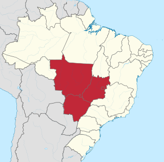
Mato Grosso do Sul is one of Brazil's 27 federal units, located in the southern part of the Central-West Region, bordering five Brazilian states: Mato Grosso, Goiás and Minas Gerais (northeast), São Paulo (east) and Paraná (southeast); and two South American countries: Paraguay and Bolivia (west). It is divided into 79 municipalities and covers an area of 357,145.532 square kilometers, which is about the same size as Germany. With a population of 2,839,188 inhabitants in 2021, Mato Grosso do Sul is the 21st most populous state in Brazil.

The Central-West or Center-West Region of Brazil is composed of the states of Goiás, Mato Grosso and Mato Grosso do Sul; along with Distrito Federal, where Brazil's national capital, Brasília, is situated. The region comprises 18.86% of the national territory, and is the least populated in Brazil.
Bella Vista is a border town in northeast of Paraguay, bordering the Brazilian town of Bela Vista, Mato Grosso do Sul. Both towns are divided by the Apa River, only connected by a borderbridge. It is a small town in the northern region of Amambay. Getting there is possible by way of Brazil or over a red earth road from the Paraguayan country-side.

Dalechampia is a genus of plant of the family Euphorbiaceae and of the monogeneric subtribe Dalechampiinae. It is widespread across lowland tropical areas primarily in the Americas with smaller numbers of species in Africa, Madagascar, and southern Asia. Additional new species are still being described and several are very rare and at risk of extinction.

Miranda is a municipality located in the Brazilian state of Mato Grosso do Sul, Brazil, named for its location on the river by the same name. Its population was 28,220 in 2020 and its area is 5,479 km2.
Rio Negro is a municipality located in the Brazilian state of Mato Grosso do Sul. Its population was 4,793 (2020) and its area is 1,808 km².
The Aporé River is a river forming the border between Goiás and Mato Grosso do Sul states in central Brazil. It is a tributary of the Paranaíba River, which enters the reservoir created by Ilha Solteira Dam on the Paraná River.
The Parecis River is a river of the Mato Grosso state in western Brazil.

The Anhanduìzinho River is a river of Mato Grosso do Sul state in southwestern Brazil.

The Iguatemi River is a river of Mato Grosso do Sul state in southwestern Brazil.

The Miranda River is a river of Mato Grosso do Sul state in southwestern Brazil. It is a tributary of the Paraguay River. The river flows north and south, and forms the border between Brazil and Paraguay.

The Rio Negro is a river of Mato Grosso do Sul state in southwestern Brazil.
The Nioaque River is a river of Mato Grosso do Sul state in southwestern Brazil. It is a tributary of the Miranda River, and part of the Paraguay River basin.
The Pardo River is a river of Mato Grosso do Sul state in southwestern Brazil. It is a tributary of the Paraná River, which it enters in the reservoir of Sérgio Motta Dam.

The Piripucu River is a river of Mato Grosso do Sul state in southwestern Brazil.
The Pântano River is a river of Mato Grosso do Sul state in southwestern Brazil.
The Salobra River is a river of Mato Grosso do Sul state in Midwest Brazil. It is a tributary of the Miranda River, itself a part of the Paraguay River basin.

The Sucuriú River is a river located in the Mato Grosso do Sul state in southwestern Brazil. It is a tributary of the Paraná River, which it joins just upriver of Eng Souza Dias (Jupiá) Dam.
The Taboco River is a river of Mato Grosso do Sul state in southwestern Brazil.


