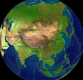
Bengal is a historical geographical, ethnolinguistic and cultural term referring to a region in the eastern part of the Indian subcontinent at the apex of the Bay of Bengal. The region of Bengal proper is divided between the modern-day sovereign nation of Bangladesh and the Indian state of West Bengal.

Northern Samar, officially the Province of Northern Samar, is a province in the Philippines located in the Eastern Visayas region. Its capital is Catarman, the most populous town in the province and is located at the northern portion of the island of Samar. Bordering the province to the south are the provinces of Samar and Eastern Samar. To the northwest, across the San Bernardino Strait is Sorsogon; to the east is the Philippine Sea of the Pacific Ocean and to the west is Samar Sea.

The First Anglo-Burmese War, also known as the First Burma War in English language accounts and First English Invasion War in Burmese language accounts, was the first of three wars fought between the British and Burmese empires in the 19th century. The war, which began primarily over the control of what is now Northeastern India, ended in a decisive British victory, giving the British total control of Assam, Manipur, Cachar and Jaintia as well as Arakan Province and Tenasserim. The Burmese submitted to a British demand to pay an indemnity of one million pounds sterling, and signed a commercial treaty.

Sittwe , formerly Akyab (အာကျပ်), is the capital of Rakhine State, Myanmar (Burma). Sittwe is located on an estuarial island created at the confluence of the Kaladan, Mayu, and Lay Mro rivers emptying into the Bay of Bengal. As of 2006 the city has 181,000 inhabitants. It is the administrative seat of Sittwe Township and Sittwe District.

Antipas, officially the Municipality of Antipas, is a 2nd class municipality in the province of Cotabato, Philippines. According to the 2020 census, it has a population of 26,817 people.

Arakan, officially the Municipality of Arakan is a 1st class municipality in the province of Cotabato, Philippines. According to the 2020 census, it has a population of 50,558 people.
The Chin Hills are a range of mountains in Chin State, northwestern Burma (Myanmar), that extends northward into India's Manipur state.

The Arakan Mountains, natively referred as Rakhine Yoma and technically known as the Southern Indo-Burman Range, are a mountain range in western Myanmar, between the coast of Rakhine State and the Central Myanmar Basin, in which flows the Irrawaddy River. It is the most prominent of a series of parallel ridges that arc through Assam, Nagaland, Manipur, Mizoram and Myanmar.

Sir Arthur Purves Phayre was a career British Indian Army officer who was the first Commissioner of British Burma, 1862–1867, Governor of Mauritius, 1874–1878, and author.

The 26th Indian Infantry Division, was an infantry division of the Indian Army during World War II. It fought in the Burma Campaign.

Samataṭa was an ancient geopolitical division of Bengal in the eastern Indian subcontinent. The Greco-Roman account of Sounagoura is linked to the kingdom of Samatata. Its territory corresponded to much of present-day eastern Bangladesh and parts of the Rakhine State of Myanmar. The area covers the trans-Meghna part of the Bengal delta. It was a center of Buddhist civilisation before the resurgence of Hinduism, and Muslim conquest in the region.

The Bengal Sultanate (Middle Bengali: শাহী বাঙ্গালা, Classical Persian: سلطنت بنگاله was a late medieval sultanate based in the Bengal region in the eastern Indian subcontinent between the 14th and 16th century. It was the dominant power of the Ganges-Brahmaputra Delta, with a network of mint towns spread across the region. The Bengal Sultanate had a circle of vassal states in the Indian subcontinent, including parts of Odisha in the southwest, Arakan in the southeast, and Tripura in the east.

The Arakan campaign of 1942–1943 was the first tentative Allied attack into Burma, following the Japanese invasion of Burma earlier in 1942, during the Second World War. The British Army and British Indian Army were not ready for offensive actions in the difficult terrain they encountered, nor had the civil government, industry and transport infrastructure of Eastern India been organised to support the Army on the frontier with Burma. Japanese defenders occupying well-prepared positions repeatedly repulsed the British and Indian forces, who were then forced to retreat when the Japanese received reinforcements and counter-attacked.

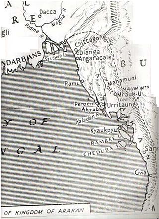
The Kingdom of Mrauk-U was a kingdom that existed on the Arakan littoral from 1429 to 1785. Based in the capital Mrauk-U, near the eastern coast of the Bay of Bengal, the kingdom ruled over what is now Rakhine State, Myanmar and southern part of Chittagong Division, Bangladesh. Though started out as a protectorate of the Bengal Sultanate from 1429 to 1531, Mrauk-U went on to conquer Chittagong with the help of the Portuguese. It twice fended off the Toungoo Burma's attempts to conquer the kingdom in 1546–1547, and 1580–1581. At its height of power, it briefly controlled the Bay of Bengal coastline from the Sundarbans to the Gulf of Martaban from 1599 to 1603. In 1666, it lost control of Chittagong after a war with the Mughal Empire. Its reign continued until 1785, when it was conquered by the Konbaung dynasty of Burma.
The 1762 Arakan earthquake occurred at about 17:00 local time on 2 April, with an epicentre somewhere along the coast from Chittagong to Arakan in modern Myanmar. It had an estimated moment magnitude between 8.5 and 8.8 and a maximum estimated intensity of XI (Extreme). It triggered a local tsunami in the Bay of Bengal and caused at least 200 deaths. The earthquake was associated with major areas of both uplift and subsidence. It is also associated with a change in course of the Brahmaputra River to from east of Dhaka to 150 kilometres (93 mi) to the west via the Jamuna River.
Ilianen is a Manobo language of Mindanao in the Philippines.
Min Khamaung also known as Hussein Shah; was the king of Arakan from 1612 to 1622.

Maha Thammada, born Thado Aung, was the final monarch of the Kingdom of Mrauk U, reigning from 1782 to 1785. He was the final Rakhine monarch.

Arakan is the historical geographical name of Rakhine State, Myanmar. The region was called Arakan for centuries until the Burmese military junta changed its name in 1989. The people of the region were known as Arakanese.
The restoration of Min Saw Mon was a military campaign led by the Bengal Sultanate to help Min Saw Mon regain control of his Launggyet Dynasty. The campaign was successful. Min Saw Mon was restored to the Launggyet throne, and n Arakan became a vassal state of the Bengal Sultanate.


