
The Darling Scarp, also referred to as the Darling Range or Darling Ranges, is a low escarpment running north–south to the east of the Swan Coastal Plain and Perth, Western Australia. The escarpment extends generally north of Bindoon, to the south of Pemberton. The adjacent Darling Plateau goes easterly to include Mount Bakewell near York and Mount Saddleback near Boddington. It was named after the Governor of New South Wales, Lieutenant-General Ralph Darling.

The Gunnison River is located in western Colorado, United States and is one of the largest tributaries of the Colorado River.

Warragamba Dam is a heritage-listed dam in the outer South Western Sydney suburb of Warragamba, Wollondilly Shire in New South Wales, Australia. It is a concrete gravity dam, which creates Lake Burragorang, the primary reservoir for water supply for the city of Sydney. The dam wall is located approximately 65 kilometres (40 mi) W of Sydney central business district, 4½ km SW of the town of Wallacia, and 1 km NW of the village of Warragamba.
The Shoalhaven River is a perennial river that rises from the Southern Tablelands and flows into an open mature wave dominated barrier estuary near Nowra on the South Coast of New South Wales, Australia.

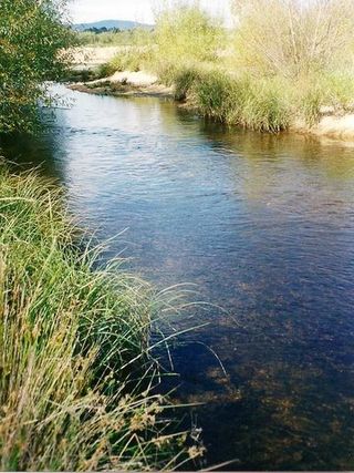
The Stanley River is a perennial river in the South East region of Queensland, Australia. A major tributary of the Brisbane River, the Stanley River valley extends roughly 35 kilometres (22 mi) westwards from the area south of Maleny, through Woodford to Kilcoy before veering southwards.

The Wivenhoe Dam is a rock and earth-fill embankment dam with a concrete spillway across the Brisbane River in South East Queensland, Australia. The dam takes it names from the local Wivenhoe Pocket rural community. The dam wall is located about 80 kilometres (50 mi) by road from the centre of Brisbane. The primary purpose of the dam is the supply of potable water for the Brisbane and Ipswich regions. South-east Queensland's largest dam also provides for flood mitigation control, hydroelectricity, and recreation. The impounded reservoir is called Lake Wivenhoe and the dam, the lake and a narrow strip of surrounding land forms a locality also called Lake Wivenhoe.

The California State Water Project, commonly known as the SWP, is a state water management project in the U.S. state of California under the supervision of the California Department of Water Resources. The SWP is one of the largest public water and power utilities in the world, providing drinking water for more than 27 million people and generating an average of 6,500 GWh of hydroelectricity annually. However, as it is the largest single consumer of power in the state itself, it has a net usage of 5,100 GWh.

The Serpentine Dam is a major water supply dam for Perth, Western Australia. The dam is used to store water that is released at a controlled rate to regulate the level in the Serpentine Pipehead Dam reservoir, which in turn feeds water to the metropolitan trunk main network depending on demand. Construction of the dam was completed in 1961.

The Goldfields Water Supply Scheme is a pipeline and dam project that delivers potable water from Mundaring Weir in Perth to communities in Western Australia's Eastern Goldfields, particularly Coolgardie and Kalgoorlie. The project was commissioned in 1896 and completed in 1903.

South Dandalup Dam is a dam in Western Australia. It is located where the South Dandalup River flows out of Lake Banksiadale. The dam was built in 1971 in response to rapid population growth in Perth, Western Australia's capital city, and a resources boom in the Pilbara.

The Canning Dam and reservoir are a major source of fresh water for the city of Perth, Western Australia. The dam is situated on the Darling Scarp and is an impoundment of the Canning River. It is noted for its innovative structural and hydraulic design that was considered to be at the forefront of concrete gravity dam design at the time of construction in from 1933 to its completion 1940.
Hyden Humps Dam is situated at the southern base of The Humps, approximately seventeen kilometres north east of Hyden and fifteen kilometres north of Wave Rock.

Seqwater is a statutory authority of the Government of Queensland that provides bulk water storage, transport and treatment, water grid management and planning, catchment management and flood mitigation services to the South East Queensland region of Australia. Seqwater also provides irrigation services to about 1,200 rural customers in the region that are not connected to the grid and provides recreation facilities.
The Philippines' contemporary water supply system dates back to 1946, after the country declared independence. Government agencies, local institutions, non-government organizations, and other corporations are primarily in charge of the operation and administration of water supply and sanitation in the country.

Churchman Brook Dam is an earth-fill embankment dam approximately 30 kilometres (20 mi) southeast of Perth, Western Australia in the City of Armadale. The reservoir is a water source for Perth.

California's interconnected water system serves almost 40 million people and irrigates over 5,680,000 acres (2,300,000 ha) of farmland. As the world's largest, most productive, and potentially most controversial water system, it manages over 40 million acre-feet (49 km3) of water per year. Use of available water averages 50% environmental, 40% agricultural and 10% urban, though this varies considerably by region and between wet and dry years. In wet years, "environmental" water averages 61%, while in dry years it averages 41%, and can be even lower in critically dry years.

The Canning Contour Channel is a 16 kilometres (9.9 mi) series of man-made concrete channels and steel and cast-iron pipelines in the Darling Scarp in Western Australia constructed between July 1935 and December 1936. The project was a Depression era public works scheme to carry potable water from just below Canning Dam through the hills around and above Roleystone and Kelmscott to a screening, fluoridation and pumping station near Gosnells by following the natural contours of the Canning Valley—hence it was entirely gravity-fed. Where a tributary valley needed to be crossed, suspended or siphoning pipelines were used. From Gosnells, the water entered the city's pipeline distribution system.
Water security in Australia became a major concern in Australia in the late 20th and early 21st century as a result of population growth, recurring severe droughts, effects of climate change on Australia, environmental degradation from reduced environmental flows, competition between competing interests such as grazing, irrigation and urban water supplies, and competition between upstream and downstream users. For example, there is competition for the resources of the Darling River system between Queensland, New South Wales and South Australia. Water reform was first placed on the national agenda at the 1994 Council of Australian Governments (COAG) meeting when a strategic framework was devised. As the knowledge of surface and groundwater systems grew and the awareness of the significance of sustainable water markets increased, further water reform was agreed to at the 2004 COAG meeting, under a national blueprint known as the National Water Initiative (NWI).

The Yanga National Park is a newly formed national park, located near the township of Balranald in south- western New South Wales. It covers an area of 66,734 hectares which includes 1,932 hectares of Yanga Nature Reserve, and has a frontage of 170 kilometres (110 mi) on the Murrumbidgee River. It is largely located in the Lower Murrumbidgee Floodplain, which is included on A Directory of Important Wetlands in Australia because of its importance as a breeding site for waterbirds when flooded.

North Dandalup Dam is a dam in Western Australia. It is located 63.8 kilometres (39.6 mi) south of Perth in the Darling Scarp, which forms the western border of the Darling Ranges. Constructed in 1994, it was opened by state Premier Richard Court in October of that year. It was the final project in a dam-building scheme that also includes the Victoria and Conjurunjup Dams.
