
Chur or Coire is the capital and largest town of the Swiss canton of Grisons and lies in the Grisonian Rhine Valley, where the Rhine turns towards the north, in the northern part of the canton. The city, which is located on the right bank of the Rhine, is reputedly the oldest town of Switzerland.

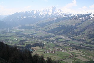
Reichenau is a village in the municipality of Tamins in the Canton of Graubünden, Switzerland, where the two Rhine tributaries Vorderrhein and Hinterrhein meet, forming the Alpine Rhine. It is a major traffic junction of the routes from Chur towards the Oberalp Pass and Lukmanier Pass and from Chur towards San Bernardino Pass and Julier Pass.

Vals is a village and a municipality in the Surselva Region in the canton of Graubünden in Switzerland. On 1 January 2015 the former municipality of St. Martin merged into the municipality of Vals.

Engstingen is a municipality in the Tübingen administrative region (Regierungsbezirk) in Baden-Württemberg, Germany. It lies in the Swabian Jura (plateau), about 15 kilometres (9.3 mi) south of Reutlingen.

Plessur District is a former administrative district in the canton of Graubünden, Switzerland. It had an area of 266.73 km2 (102.99 sq mi) and has a population of 40,707 in 2015. The former district is named after the river Plessur which crosses it. However, the region along the Plessur –and therefore the whole valley–is called Schanfigg. It was replaced with the Plessur Region on 1 January 2017 as part of a reorganization of the Canton.

Lumnezia is a valley region and a municipality in the Surselva Region in the Swiss of canton of Graubünden. The former municipalities of Cumbel, Degen, Lumbrein, Morissen, Suraua, Vignogn, Vella, and Vrin merged on 1 January 2013 into the new municipality of Lumnezia. It covers the (Val) Lumnezia, a Swiss high alpine valley. Its upper regions are among the most remote areas in the Swiss Alps. The official language is Romansh Sursilvan.

Disentis Abbey is a Benedictine monastery in the Canton of Graubünden in eastern Switzerland, around which the present town of Disentis grew up.

Pfäfers Abbey, also known as St. Pirminsberg from its position on a mountain, was a Benedictine monastery in Pfäfers near Bad Ragaz, in the canton of St. Gallen, Switzerland.

Lavizzara is a municipality in the district of Vallemaggia in the canton of Ticino in Switzerland.

Alto Malcantone is a municipality in the district of Lugano in the canton of Ticino in Switzerland. It was formed on 13 March 2005 from the earlier municipalities of Arosio, Breno, Fescoggia, Mugena and Vezio.

Untervaz is a municipality in the Landquart Region in the Swiss canton of Graubünden.
Loco is a village and former municipality in the canton of Ticino, Switzerland.

The Schams is a section of the Hinterrhein valley in the Swiss canton of Graubünden.
The Domleschg is a valley in Graubünden in Switzerland. Geographically, the name "Domleschg" covers both sides of the valley. Politically, the villages on the left bank of the Posterior Rhine form the Kreis (sub-district) of Thusis and those on the right bank form the Kreis of Domleschg. Thusis is the main village in the valley. The northernmost locality is Rothenbrunnen, the southernmost is Sils.
Castelmur Castle is a castle in the village of Bondo in the municipality of Bregaglia of the Canton of Graubünden in Switzerland. It is a Swiss heritage site of national significance. The fortifications at Castelmur may be, after the Three Castles of Bellinzona, the most important example of medieval valley fortifications in modern Switzerland.

Marschlins Castle is a castle in the village of Igis of the municipality of Landquart of the Canton of Graubünden in Switzerland. It is a Swiss heritage site of national significance.

Albula/Alvra is a municipality in the Albula Region in the canton of Graubünden in Switzerland. On 1 January 2015 the former municipalities of Alvaschein, Mon, Stierva, Tiefencastel, Alvaneu, Brienz/Brinzauls and Surava merged to form the new municipality of Albula/Alvra.
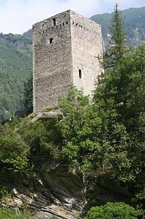
Spaniola Castle is a ruined castle in the municipality of Pontresina of the Canton of Graubünden in Switzerland.

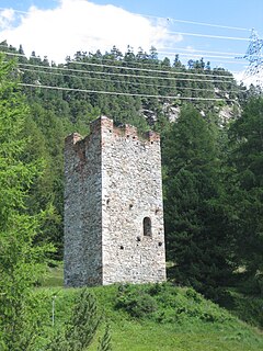
The Planta Tower is a tower house in the center of the municipality of Zuoz in the Canton of Graubünden in Switzerland.

Lichtenstein Castle is a ruined castle in the municipality of Haldenstein of the Canton of Graubünden in Switzerland.
