Aravathur is a small village in Mannargudi taluk, Tiruvarur district, Tamil Nadu, India. The name Aravathur is termed from "Aravam" (meaning 'snake'). The main occupation is farming paddy lands. The Mariamman Kovil temple is located here.
Aravathur is a small village in Mannargudi taluk, Tiruvarur district, Tamil Nadu, India. The name Aravathur is termed from "Aravam" (meaning 'snake'). The main occupation is farming paddy lands. The Mariamman Kovil temple is located here.

Garrett County is the westernmost county of the U.S. state of Maryland completely within the Appalachian Mountains. As of the 2020 census, the population was 28,806, making it the third-least populous county in Maryland. Its county seat is Oakland. The county was named for John Work Garrett (1820–1884), president of the Baltimore and Ohio Railroad. Created from Allegany County in 1872, it was the last county to be formed in the state.

The Arctic Archipelago, also known as the Canadian Arctic Archipelago, is an archipelago lying to the north of the Canadian continental mainland, excluding Greenland and Iceland.
79 (seventy-nine) is the natural number following 78 and preceding 80.
The equivalent air depth (EAD) is a way of approximating the decompression requirements of breathing gas mixtures that contain nitrogen and oxygen in different proportions to those in air, known as nitrox.
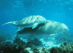
The Gulf of Mannar Marine National Park is a protected area of India consisting of 21 small islands (islets) and adjacent coral reefs in the Gulf of Mannar in the Indian Ocean. It lies 1 to 10 km away from the east coast of Tamil Nadu, India for 160 km between Thoothukudi (Tuticorin) and Dhanushkodi. It is the core area of the Gulf of Mannar Biosphere Reserve which includes a 10 km buffer zone around the park, including the populated coastal area. The park has a high diversity of plants and animals in its marine, intertidal and near shore habitats. Public access inside the park is limited to glass-bottom boat rides. It was established as a National Park in 1986.

Desur is a Town panchayat in Tiruvanamalai district in the Indian state of Tamil Nadu.
Vengathur is a census town in Thiruvallur district in the Indian state of Tamil Nadu.
Parrish Glacier is a glacier on central Ellesmere Island, Nunavut, Canada.
Strand Fiord Pass is a mountain pass on southern Axel Heiberg Island, Nunavut, Canada.
Aonla Lok Sabha constituency is one of the 80 Lok Sabha (parliamentary) constituencies in Uttar Pradesh state in northern India.

Mainpuri Lok Sabha constituency is one of the 80 Lok Sabha (parliamentary) constituencies in the Indian state of Uttar Pradesh.

The Whites' Woods Nature Center is a 250-acre (1.0 km2) nature center in Indiana County, Pennsylvania, USA. It is publicly owned by White Township.
Bhandara is one of the 288 Vidhan Sabha constituencies in Maharashtra state in central India. This constituency is one of the three constituencies located in Bhandara district.
Kilvelur is a state assembly constituency in Tamil Nadu, India newly formed after constituency delimitations 2008. It is included in the Nagapattinam parliamentary constituency. It comprises kilvelur, keezhayur and a part of Nagapattinam panchayat union. It is one of the 234 State Legislative Assembly Constituencies in Tamil Nadu in India.

Rajampet Assembly constituency is a constituency in Annamaya district of Andhra Pradesh that elects representatives to the Andhra Pradesh Legislative Assembly in India. It is one of the seven assembly segments in the Rajampet Lok Sabha constituency.
Thamaraipakkam is a village in Arcot Taluk of Ranipet district in the state of Tamil Nadu, India.
Walajabad taluk is a taluk in the Kanchipuram district of Tamil Nadu, India. At the 2011 Census of India, the taluk covered an area of 339.03 square kilometres (130.90 sq mi) with a population of 125,868. The headquarters of the taluk is the town of Walajabad.
ERB-79 is a synthetic estrogen and a selective agonist of the ERβ. It is a racemic mixture, with the active enantiomer being ERB-26. ERB-79 shows more than 484-fold selectivity for transactivation of the ERβ over the ERα. Its EC50 value for the ERβ is 0.448 nM (14.52% of the potency of estradiol) and for the ERα is 79 nM (0.03% of the potency of estradiol). It has no antagonistic activity at either receptor. ERB-79 is active in preclinical models of arthritis. The chemical structure of ERB-79 does not appear to have been disclosed.
Hastinapuram is a neighbourhood of Hyderabad. It is located towards Nagarjuna Sagar highway road. Its neighbouring areas are B.N. Reddy Nagar, Vanasthali Puram and LB Nagar. Also NGO colony, Christian colony. The area is divided into four parts, East Hastinapuram, West Hastinapuram, South Hastinapuram and Central Hastinapuram. LB Nagar will be the nearest station of Hyderabad Metro Train. Tourism destinations like Ramoji Film City, and Mount Opera are located within 10–15 km. The distance to Hyderabad Airport is 25 km. G.Surya Prakash, the Legend lives in Hastinapuram.
Auraiya is a constituency of the Uttar Pradesh Legislative Assembly covering the city of Auraiya in the Auraiya district of Uttar Pradesh, India.
10°41′32″N79°28′36″E / 10.692232°N 79.476594°E
| | This article related to a location in Tiruvarur district, Tamil Nadu, India is a stub. You can help Wikipedia by expanding it. |