
Musselburgh is the largest settlement in East Lothian, Scotland, on the coast of the Firth of Forth, 5 miles (8 km) east of Edinburgh city centre. It has a population of 20,840.
Donaldson's School, in Linlithgow is Scotland's national residential and day school, providing education, therapy and care for pupils who are deaf or who have communication difficulties.
Walston is a hamlet in the middle of black mount area of South Lanarkshire.

Montrose Academy is a secondary school in Montrose Angus. The School now teaches people from ages 11-18. It is now a comprehensive school which serves the surrounding local community with a roll of around 900 students and a staff of 79. Most pupils come from the associated primary schools of Borrowfield, Ferryden, Lochside, Rosemount, Southesk and St Margaret's. A number of pupils come from outside the catchment area.
Monifieth is a town and former police burgh in the council area of Angus, Scotland. It is situated on the north bank of the Firth of Tay on the east coast. In 2016, the population of Monifieth was estimated at 8,110, making it the fifth largest town in Angus.

Inverness Royal Academy is a comprehensive secondary school in the city of Inverness in the Highland area of Scotland.

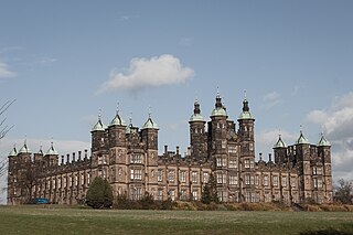
Liff is a village in Angus, Scotland, situated 4.5 miles west-north-west of Dundee on a south-facing slope two miles north of the River Tay. It had a population of 568 in 2011. Surrounded by farmland, it has been described as 'haunted by wood pigeons and the scent of wild garlic' and having a 'wonderful view over the firth [of Tay]'. Half a mile to the east lies the site of the former Royal Dundee Liff Hospital, now given over to private housing. Further east lie Camperdown House and Park. Half a mile to the south is House of Gray, a large eighteenth-century mansion house in the neoclassical style, currently standing empty. The village contains twelve listed buildings, with others nearby.

Bridge of Earn is a small town in Perthshire, Scotland. Often referred to simply as 'The Brig'. The village grew up on the south bank of an important crossing of the River Earn, whose sandstone bridge existed from at least the early 14th century, when it is known to have been repaired by order of King Robert I of Scotland (1306–1329). Substantial remains of the medieval bridge survived into the 1970s, when almost all the stonework was demolished, for (allegedly) being in a dangerously ruinous condition. This ancient bridge was a major landmark on the road between Edinburgh and Perth for several centuries. The village's oldest houses are to be found lining the road leading south from the site of the demolished bridge. Among them are some with 18th-century datestones.

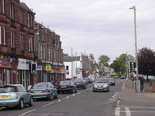
Chryston is a village in North Lanarkshire, around 7 miles (11 km) east of Glasgow, in Scotland. It lies north of its sister village, Muirhead, which is on the A80. The village has around double Muirhead's population although the exact boundary between the two modern villages is difficult to find.
Carmyllie is a rural parish in Angus, Scotland. It is situated on high ground between Arbroath, on the coast, and the inland county town of Forfar. The main settlements in the parish are Redford, Greystone, Guynd and Milton of Carmyllie. There is a Church of Scotland church and a primary school. The Elliot Water rises in the west of the parish.

Lasswade High School is a non-denominational secondary state school in Bonnyrigg, Midlothian, Scotland.
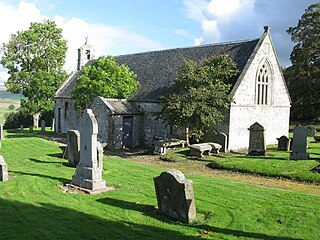
Arbirlot is a village in a rural parish of the same name in Angus, Scotland. The current name is usually presumed to be a contraction of Aberelliot or Aber-Eliot - both meaning the mouth of the Elliot. It is situated west of Arbroath. The main village settlement is on the Elliot Water, 2.5 miles from Arbroath. There is a Church of Scotland church and a primary school. The school lies 1 mile further west in the approximate geographic centre of the parish.

Forgandenny is a small village in Perth and Kinross, Scotland, located four miles south of Perth. Perth is a 20-minute bus ride from Forgandenny, and there is a regular Stagecoach service. It is 45 minutes from Edinburgh and one hour from Glasgow. There is a daily train service from Perth to London King's Cross.

Auchterhouse is a village, community, and civil parish in the Scottish council area of Angus, located 7.3 miles (11.7 km) north west of Dundee, 9.5 miles (15.3 km) south east of Alyth and 14.9 miles (24.0 km) south west of Forfar. It lies on the southern edge of the Sidlaw Hills, below Auchterhouse Hill, 1,398 feet (426 m) high. The parish, which is coterminous with the community, had a population of 520 in 2001. The village, formerly known as Milltown of Auchterhouse, straddles the B954 Muirhead to Newtyle road. About 1.0 mile (1.6 km) east lies the larger village of Kirkton of Auchterhouse, where the church and school are located.

Muirhead is a small town approximately 7 miles (11 km) north-east of Glasgow city centre. Nearby villages and towns include Chryston, Garnkirk, Gartcosh, Moodiesburn, Lenzie and Stepps. Muirhead has a population of around 1,390. It is a commuter town to Glasgow with road links with the A80/M80 and frequent bus services the 37c x35, x37, and x3. Muirhead is located approximately two miles from Gartcosh, Lenzie and Stepps railway stations.

Carnock is a village and parish of Fife, Scotland, 4+1⁄4 miles west of Dunfermline. It is 1+1⁄4 miles east of Oakley, Fife. The name of the village derives from Scottish Gaelic, from ceàrn ("corner"), with a suffix denoting a toponym, thus giving "[the] corner place". Carnock is known to have had military significance in antiquity. The civil parish had a population of 5,927 as of 2011.

Caddonfoot is a village on the River Tweed, in the Scottish Borders area of Scotland, on the A707, near Galashiels.

Caputh is a parish and village in Perth and Kinross, Scotland. It lies on the A984 Coupar Angus to Dunkeld road about 6 miles southeast of Dunkeld and 8 miles west of Coupar Angus.

Kingskettle or often simply Kettle is a village and parish in Fife, Scotland. Encompassed by the Howe of Fife, the village is approximately 5.5 miles (9 km) southwest of the nearest town, Cupar, and 22 miles (35 km) north of Edinburgh. According to the 2011 Census for Scotland, the Kettle parish had a population of 1,645, of which 1,002 lived in the village.

Kirkgunzeon is a village and civil parish in Dumfries and Galloway, south west Scotland. The village is 10.4 miles (16.7 km) south west of Dumfries and 4.1 miles (6.6 km) north east of Dalbeattie. The civil parish is in the former county of Kirkcudbrightshire, and is bounded by the parishes Lochrutton to the north, Urr to the west, Colvend and Southwick to the south and New Abbey to the east.
