Esri is an American multinational geographic information system (GIS) software company. It is best known for its ArcGIS products. With a 43% market share, Esri is the world's leading supplier of GIS software, web GIS and geodatabase management applications. The company is headquartered in Redlands, California.
Btrieve is a transactional database software product. It is based on Indexed Sequential Access Method (ISAM), which is a way of storing data for fast retrieval. There have been several versions of the product for DOS, Linux, older versions of Microsoft Windows, 32-bit IBM OS/2 and for Novell NetWare.
Installation of a computer program, is the act of making the program ready for execution. Installation refers to the particular configuration of a software or hardware with a view to making it usable with the computer. A soft or digital copy of the piece of software (program) is needed to install it. There are different processes of installing a piece of software (program). Because the process varies for each program and each computer, programs often come with an installer, a specialised program responsible for doing whatever is needed for the installation. Installation may be part of a larger software deployment process.
A GIS software program is a computer program to support the use of a geographic information system, providing the ability to create, store, manage, query, analyze, and visualize geographic data, that is, data representing phenomena for which location is important. The GIS software industry encompasses a broad range of commercial and open-source products that provide some or all of these capabilities within various information technology architectures.

Manifold System is a geographic information system (GIS) software package developed by Manifold Software Limited that runs on Microsoft Windows. Manifold System handles both vector and raster data, includes spatial SQL, a built-in Internet Map Server (IMS), and other general GIS features.
Spatial network analysis software packages are analytic software used to prepare graph-based analysis of spatial networks. They stem from research fields in transportation, architecture, and urban planning. The earliest examples of such software include the work of Garrison (1962), Kansky (1963), Levin (1964), Harary (1969), Rittel (1967), Tabor (1970) and others in the 1960s and 70s. Specific packages address to suit their domain-specific needs, including TransCAD for transportation, GIS for planning and geography, and Axman for Space syntax researchers.
ArcSDE is a server-software sub-system that aims to enable the usage of Relational Database Management Systems for spatial data. The spatial data may then be used as part of a geodatabase.

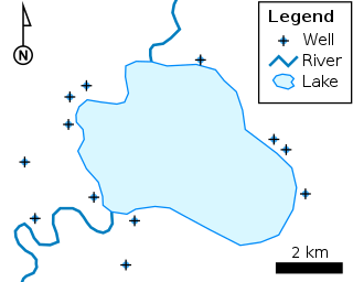
The shapefile format is a geospatial vector data format for geographic information system (GIS) software. It is developed and regulated by Esri as a mostly open specification for data interoperability among Esri and other GIS software products. The shapefile format can spatially describe vector features: points, lines, and polygons, representing, for example, water wells, rivers, and lakes. Each item usually has attributes that describe it, such as name or temperature.

ArcGIS is a family of client, server and online geographic information system (GIS) software developed and maintained by Esri. ArcGIS was first released in 1999 and originally was released as ARC/INFO, a command line based GIS system for manipulating data. ARC/INFO was later merged into ArcGIS Desktop, which was eventually superseded by ArcGIS Pro in 2015. ArcGIS Pro works in 2D and 3D for cartography and visualization, and includes artificial Intelligence (AI).

Java Unified Mapping Program (JUMP) is a Java based vector and raster GIS and programming framework. Current development continues under the OpenJUMP name.
ArcInfo is a full-featured geographic information system produced by Esri, and is the highest level of licensing in the ArcGIS Desktop product line. It was originally a command-line based system. The command-line processing abilities are now available through the GUI of the ArcGIS Desktop product.

The Geospatial Data Abstraction Library (GDAL) is a computer software library for reading and writing raster and vector geospatial data formats, and is released under the permissive X/MIT style free software license by the Open Source Geospatial Foundation. As a library, it presents a single abstract data model to the calling application for all supported formats. It may also be built with a variety of useful command line interface utilities for data translation and processing. Projections and transformations are supported by the PROJ library.
MapInfo Pro is a desktop geographic information system (GIS) software product produced by Precisely and used for mapping and location analysis. MapInfo Pro allows users to visualize, analyze, edit, interpret, understand and output data to reveal relationships, patterns, and trends. MapInfo Pro allows users to explore spatial data within a dataset, symbolize features, and create maps.
ArcExplorer is a lightweight data viewer from ESRI for maps and GIS data in these formats:
ArcGIS Server is the core server geographic information system (GIS) software made by Esri. ArcGIS Server is used for creating and managing GIS Web services, applications, and data. ArcGIS Server is typically deployed on-premises within the organization’s service-oriented architecture (SOA) or off-premises in a cloud computing environment.
ArcMap is the main component of Esri's ArcGIS suite of geospatial processing programs, and is used primarily to view, edit, create, and analyze geospatial data. ArcMap allows the user to explore data within a data set, symbolize features accordingly, and create maps. This is done through two distinct sections of the program, the table of contents and the data frame. In October 2020, it was announced that there are no plans to release 10.9 in 2021, and that ArcMap would no longer be supported after March 1, 2026. Esri are encouraging their users to transition to ArcGIS Pro.
ArcView is the entry level licensing level of ArcGIS Desktop, a geographic information system software product produced by Esri. It is intended by Esri to be the logical migration path from ArcView 3.x.
MapDotNet is a suite of geographic information system (GIS) software products developed by ISC that run on Microsoft Windows. The GIS software competes with ESRI and MapInfo GIS products. MapDotNet UX is the latest generation and consists of a set of WCF web services for rendering map images and tiles and for performing spatial analysis and editing. UX includes an SDK for developing rich interactive mapping applications on Microsoft Silverlight, Windows Presentation Foundation and HTML5. MapDotNet UX also includes an Extract, Transform & Load (ETL), map design and tile cache creation tool called Studio modeled after Microsoft's Expression series of products. The MapDotNet UX renderer is built on WPF and consumes spatial data from multiple sources including Shapefiles, PostGIS, ArcSDE, Oracle Spatial, SQL Azure, SQL Server 2008 R2 and SQL Server 2012.

ArcGIS CityEngine is a commercial three-dimensional (3D) modeling program developed by Esri R&D Center Zurich and specialises in the generation of 3D urban environments. Using a procedural modeling approach, it supports the creation of detailed large-scale 3D city models. CityEngine works with architectural object placement and arrangement in the same manner that software like VUE manages terrain, ecosystems and atmosphere mapping. Unlike the traditional 3D modeling methodology which uses Computer-Aided Design (CAD) tools and techniques, CityEngine takes a different approach to shape generation via a rule-based system. It can also use Geographic Information System (GIS) datasets due to its integration with the wider Esri/ArcGIS platform. Due to this unique feature set, CityEngine has been used in academic research and built environment professions, e.g., urban planning, architecture, visualization, game development, entertainment, archeology, military and cultural heritage. CityEngine can be used within Building Information Model (BIM) workflows as well as visualizing the data of buildings in a larger urban context, enhancing its working scenario toward real construction projects.
Biosphere3D is an open-source project that targets interactive landscape scenery rendering based on a virtual globe. The software system supports multiple scales but focuses primarily on the creation of realistic views from eye-level or near ground level. The software is released under the MPL license and developed by Zuse Institute Berlin, Lenné3D and the open-source community for use on personal computers.


