

Ards Forest Park is a park in County Donegal, Ireland.
Ards Forest Park is a park in County Donegal, Ireland.
The forest park is situated on the small Ards Peninsula. It sits on the shores of Sheephaven Bay on the northern coastline of County Donegal, Ireland. It's to be found on the N56 road, between Creeslough and Dunfanaghy. Ards Forest Park was formerly part of the Ards Estate, a country estate purchased by Alexander Stewart in the 1780s. The Ards Estate, centered on Ards House (demolished in the early 1960s), was owned by the Stewart family up until the early 1930s. The last member of the Stewart family to own the estate was Lady Ena Stewart-Bam, who inherited from her grandfather around 1904. She was the wife of Lt. Col. Sir Pieter C. van B. Stewart-Bam, Kt., O.B.E., a South African soldier, politician and businessman whom she married in 1910. The forest park is now owned by Coillte, a State body.
Today, the forest park is 481 hectares in area and contains a range of wildlife and plants, as well as the remains of four ringforts and a number of megalithic tombs. Legend has it that these tombs were the beds of Diarmuid and Gráinne in their flight from Fionn Mac Cumhaill.
The forest park has many signposted walks integrating the main features of the park. These include the Ards Heritage Trail, which is around 3.5 km long, the Nature Trail and the Green Trail, which are both approximately 3 km long, and the Red Trail, which is 13 km long, though this walk does give provisions for a short-cut back to the starting point should it be needed. There are various viewing points on the walks and trails with views of the surrounding countryside.
The Ards Heritage Trail passes a well called the Ague Well, which is alleged to be holy and have remedial powers, and a Mass rock where mass was celebrated in defiance of the Penal Laws.
The forest park also has a picnic and children's play area and a snack outlet called the Ards Coffee Tree.
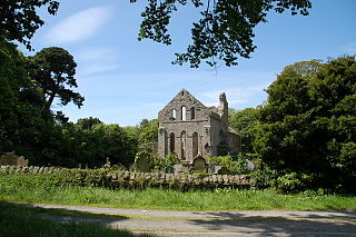
Just outside the forest park, at Ballymore on its northern border, is Clondehorky Parish Church, a Church of Ireland church built in the Georgian style in the mid-18th-century. The small parish church overlooks the N56 road, being located between Creeslough and Port-na-Blagh. It may have been designed by Micheal Priestly. Directly opposite the church's main gate is Ballymore Arch, built for the Stewart family in the 19th-century to improve access from the church to Ards House, which was several miles distant at the edge of the small Ards Peninsula.

County Down is one of the six counties of Northern Ireland, one of the nine counties of Ulster and one of the traditional thirty-two counties of Ireland. It covers an area of 961 sq mi (2,490 km2) and has a population of 531,665. It borders County Antrim to the north, the Irish Sea to the east, County Armagh to the west, and County Louth across Carlingford Lough to the southwest.

Jenkinstown Park is a park in County Kilkenny, Ireland. It is situated off the N78 road about 10 km north of the city of Kilkenny and 11 km south of Castlecomer.

The Wicklow Way is a 131-kilometre (81-mile) long-distance trail that crosses the Wicklow Mountains in Ireland. It runs from Marlay Park in the southern suburbs of Dublin through County Wicklow and ends in the village of Clonegal in County Carlow. It is designated as a National Waymarked Trail by the Irish Sports Council and is waymarked by posts with a yellow "walking man" symbol and a directional arrow. Typically completed in 5–7 days, it is one of the busiest of Ireland's National Waymarked Trails, with up to 24,000 people a year walking the most popular sections. The Way is also used regularly by a number of mountain running competitions.
Fanad is a peninsula that lies between Lough Swilly and Mulroy Bay on the north coast of County Donegal, Ireland. The origins of the name Fanad are lost in time thought there is some speculation that the name derives from an old Gaelic word Fana for "sloping ground". It is also referred to as Fannet or Fannett in older records. There are an estimated 700 people living in Fanad and 30% Irish speakers.

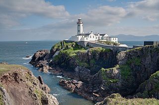
Creeslough is a village in County Donegal, Ireland, 12 kilometres (7 mi) south of Dunfanaghy on the N56 road. The small village overlooks an arm of Sheephaven Bay, with the population of the surrounding area engaged mainly in agriculture, mostly livestock rearing.

Horn Head is a peninsula in north-west County Donegal, Ireland, close to Dunfanaghy. It forms part of Sheephaven Bay.

Kinnitty is a village in County Offaly, Ireland. It is located 13 km east of Birr on the R440 and R421 regional roads.
Greyabbey or Grey Abbey is a small village, townland and civil parish located on the eastern shores of Strangford Lough, on the Ards Peninsula in County Down, Northern Ireland.
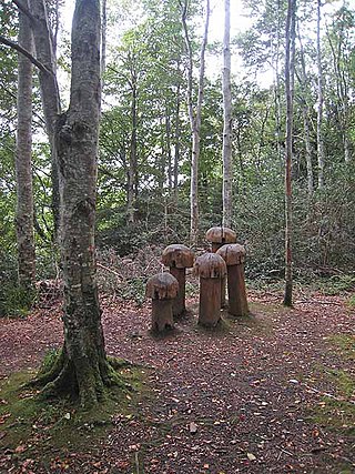
Hazelwood is an ancient area of woodland located just over 2 miles (3.2 km) outside the town of Sligo in northwest Ireland, in the parish of Calry. It is the setting for W.B.Yeats's The Song of Wandering Aengus. The wood is situated on the shores of Lough Gill, which contains Yeats's Lake Isle of Innisfree, and is popular for its scenic walks, which are dotted with sculptures. Swans, mallards and gulls congregate at the picnic area, and there is fishing on Lough Gill. The wood is part of the Hazelwood estate, owned by the Wynne family for two hundred years. The walk along forests trails provides views of the lake and Church Island, Cottage Island and Goat Island.

Clonaslee is a village in north County Laois, Ireland, situated in the foothills of the Slieve Bloom Mountains on the R422 Mountmellick to Birr road. Clonaslee is approximately 100 km west of Dublin, and is close to the towns of Portlaoise and Tullamore.

Avondale House, in Avondale, County Wicklow, Ireland, is the birthplace and home of Charles Stewart Parnell. It is set in the Avondale Forest Park, spanning over 2 km2 of land, approximately 1.5 km from the nearby town of Rathdrum. The river Avonmore flows through the park on its way towards the Irish Sea. The House is now a museum.
Avondale Forest is a wooded estate in County Wicklow, Ireland, on the west bank of the River Avonmore. It contains the home of Charles Stewart Parnell which was built in 1777 by Samuel Hayes and is now the Parnell Museum. The park is rich in wildlife and notable features include the exotic tree trail and a well-developed arboretum.

Termon is a village in the north of County Donegal, Ireland.

Bailieborough Castle was located in Bailieborough, County Cavan, Ireland. It was built in an enclosed demesne by 1629. Also known as Castle House, Lisgar House, or simply 'The Castle', the country house was located just to the south-west of Castle Lough in what is now known as Bailieborough Demesne, on the north-western edge of the town. It was largely destroyed by fire in the early 20th century and is now totally demolished.

Lough Key Forest Park is an 800-hectare park on the southern shore of Lough Key, 40 km south east of Sligo Town and 3 km east of Boyle, County Roscommon, in the Republic of Ireland. Formerly part of the Rockingham Estate laid out by the King family, it is open to the public.

Farran is a village in County Cork, Ireland, in the parish of Ovens. It lies on the southside of the River Lee. Farran is 12 miles (19 km) west from Cork City on the N22 road.

Rossmore Forest Park is a national forest park located in County Monaghan in Ireland run by the Irish States forestry organisation, Coillte. It is situated approximately 5km outside Monaghan town and has its main entrance on the R189 Threemilehouse/Newbliss Road.

The Dublin Mountains Way is a waymarked long-distance trail in the Dublin Mountains, Counties South Dublin and Dún Laoghaire–Rathdown, Ireland. The route is approximately 42 kilometres long and runs from Shankill in the east to Tallaght in the west. It has been developed by the Dublin Mountains Partnership, an umbrella group of relevant state agencies and recreational users working to improve recreational facilities in the Dublin Mountains.
Donadea is a civil parish in the barony of Ikeathy and Oughterany in the north of County Kildare, Ireland. There are seven townlands in the parish. There are no large centres of population in the parish. Donadea is noted for its public forest park which is one of the most popular outdoor venues in county Kildare. The nearest villages are Staplestown and Prosperous. The parish name is derived from a church, traditionally said to have been founded by Saint Patrick. A small 17th-century church of the Church of Ireland, St Peter's, still exists within the Donadea demesne.