Related Research Articles

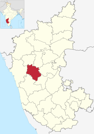
Haveri is a district in the state of Karnataka, India. As of 2011, it had a population of 1,597,668, out of which 20.78% were urban residents. The district headquarters is Haveri. Ranebennur is the biggest city in Haveri district with population and the commercial city and business headquarters and seeds production hub.

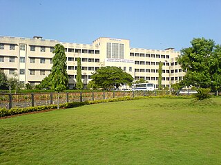
Ranibennur [Ranebennur] is a major city in Haveri district and in Central Karnataka, India.It is situated 300 kilometres (190 mi) northwest of Bengaluru, the capital of Karnataka. Other nearby cities include Hubballi (108 km) and Mangaluru (271 km). It is also the largest city in Haveri district, both in terms of Area of ULB and Population.And also main Education centre with Engineering college & several degree colleges & most Number of ICSE & CBSE Schools situated in Ranebennur city. Ranebennur is Famous for its Biranji Rice, Mirchi-Mandaki & Hesaru vade specially made Egg Rice & Delicious Ranebennur famous Mutton Enne khara food

Gadag district is a district in the state of Karnataka, India. It was formed in 1997, when it was split from Dharwad district. As of 2011, it had a population of 1064570. The overall population increased by 13.14 percent from 1991 to 2001. Gadag district borders Bagalkot district on the north, Koppal district on the east, Vijayanagara district on the southeast, Haveri district on the southwest, Dharwad district on the west and Belgaum District on the northwest. It is famous for the many monuments from the Western Chalukya Empire. It has seven talukas: Gadag, Gajendragad, Ron, Shirhatti, Nargund, Lakshmeshwar and Mundargi.

Siddharudha Swami(26 March 1836-21 August 1929) was an Indian Hindu guru and philosopher.

Sirsi, also spelled as Shirasi is a city in the Uttara Kannada district of Karnataka state in India. It was also known as "Kalyana Pattana" during the Sonda Dynasty. It is a tourist destination with evergreen forest and waterfalls and is also a commercial centre. The main businesses around the city are mostly subsistence and agriculture-based. Areca nut or betel nut, locally known as Adike, is the primary crop grown in the nearby villages, making it one of the major trading centres for areca nut. The region is also known for spices such as cardamom, pepper, betel leaves, and vanilla. The major food crop is paddy.
Dharwad or Dharawada is an administrative district of the state of Karnataka in southern India. The administrative headquarters of the district is the city of Dharwad, also known as Dharwar. Dharwad is located 425 km northwest of Bangalore and 421 km southeast of Pune, on the main highway between Chennai and Pune, the National Highway 4 (NH4).
Harapanahalli is a small city, taluk and sub-divisional headquarter in Vijayanagara District in the Indian state of Karnataka.
Hirekeruru is a panchayat town in Haveri district in the Indian state of Karnataka. The name "the village of the big pond". The name is pronounced as "Hee ray kay roor".The near by city is Ranebennur which is Rich commodity market in seeds & wholesale cloth market. Hirekerur taluk people daily come Ranebennur to shopping
Honnāli is a town and a taluk headquarter in Davanagere district in the Indian state of Karnataka. Its name is derived from honnarali, which means "Blossom of gold".
Ron is a taluka headquarters in Gadag district, Karnataka in India.
Shiggaon, also known as Shiggavi is a municipal town in Haveri district in the Indian state of Karnataka.

Karnataka, the sixth largest state in India, was ranked as the third most popular state in the country for tourism in 2014. It is home to 507 of the 3600 centrally protected monuments in India, second only to Uttar Pradesh. The State Directorate of Archaeology and Museums protects an additional 752 monuments and another 25,000 monuments are yet to receive protection.
Murgod/Murugodu is a village in the southern state of Karnataka in India. It is located in the Savadatti taluk of Belagavi district in Karnataka, 491 km from the capital Bengaluru and 54 km from district headquarters Belagavi.
Tenkayedapadavu is a panchayat village in the southern state of Karnataka, India. Administratively, it is under Mangalore taluk of Dakshina Kannada district in Karnataka. It is located at a distance of 26 km from Mangalore city. There are two villages in the gram panchayat, Tenkayedapadavu and Badagayedapadavu. The village Tenka Yedapadav is the part of Yedapadavu, divided for easier administration of village. The Post name is "Shibrikere" which means "Shabari lake". In Yedapadav there are 2 temples, the Shri Rama Mandira and the Shri Adishakthi Durga Parameshwari Temple. There are also 2 primary and secondary level schools, and one Pre-University college named "Swami Vivekananda Pre-University college, Yedapadavu". Shri Krishna Janmastami & Ramanavami are two festivals that are held in the village, with the people taking to celebrate "Masaru Kuduke ustava" in a grand manner. Yedapadav is the middle village for Ganjimatt and Moodbidiri and also Kuppe Padavu.
Medleri is a village in the southern state of Karnataka, India. It is located in the Ranibennur taluk of Haveri district in Karnataka.
Tumminakatti is a village in the southern state of Karnataka, India. It is located in the Ranibennur taluk of Haveri district in Karnataka.
Airani is a village in the southern state of Karnataka, India. It is located in the Ranibennur taluk of Haveri district in Karnataka.
Shri Kuruvathi Basaveshwara temple at Kuruvathi is one of the ancient and historic temples at the extreme south-western corner of Hoovina Hadagali taluk, Vijayanagara District, Karnataka, India. This temple is on the bank of Tungabhadra river, 10 km from Halavagalu and 2 km from Mylara and 36 km from Ranebennur and 326 km from Bangalore.

Hanamasagar (Halasagar) is a village in the southern state of Karnataka, India. It is located in Vijayapur taluk, of Vijayapur district, Karnataka and is nearly 40km from the district headquarter Vijayapur. It is a small village which is a pilgrim, having the post office at Kambagi and Babaleshwar hobli.
Pamenahalli is a village in Harihara Taluk, Karnataka, India.
References

- ↑ "DISTRICT SERVICE AREA PLAN". haveri.nic.in. Archived from the original on 4 March 2016. Retrieved 8 December 2015.
- ↑ "DISTRICT SERVICE AREA PLAN". Archived from the original on 4 March 2016.
- ↑ "NPR Report". Archived from the original on 11 December 2015. Retrieved 9 December 2015.
- ↑ Census data
- ↑ "Aremallapur Village Population - Ranibennur - Haveri, Karnataka". www.census2011.co.in. Retrieved 2 January 2018.
- ↑ "Pincode, Post office area name for pin code, Search the list of all states and cities". www.postalpincodefor.com. Retrieved 11 December 2015.