Related Research Articles

The Atlantic Ocean is the second-largest of the world's five oceans, with an area of about 85,133,000 km2 (32,870,000 sq mi). It covers approximately 20% of Earth's surface and about 29% of its water surface area. It is known to separate the "Old World" of Africa, Europe, and Asia from the "New World" of the Americas in the European perception of the World.

The country of Brazil occupies roughly half of South America, bordering the Atlantic Ocean. Brazil covers a total area of 8,514,215 km2 (3,287,357 sq mi) which includes 8,456,510 km2 (3,265,080 sq mi) of land and 55,455 km2 (21,411 sq mi) of water. The highest point in Brazil is Pico da Neblina at 2,994 m (9,823 ft). Brazil is bordered by the countries of Argentina, Bolivia, Colombia, Guyana, Paraguay, Peru, Suriname, Uruguay, Venezuela, and France.
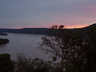
The Uruguay River is a major river in South America. It flows from north to south and forms parts of the boundaries of Brazil, Argentina, and Uruguay, separating some of the Argentine provinces of La Mesopotamia from the other two countries. It passes between the states of Santa Catarina and Rio Grande do Sul in Brazil; forms the eastern border of the provinces of Misiones, Corrientes, and Entre Ríos in Argentina; and makes up the western borders of the departments of Artigas, Salto, Paysandú, Río Negro, Soriano, and Colonia in Uruguay.

The Gulf Coastal Plain extends around the Gulf of Mexico in the Southern United States and eastern Mexico.

A submarine canyon is a steep-sided valley cut into the seabed of the continental slope, sometimes extending well onto the continental shelf, having nearly vertical walls, and occasionally having canyon wall heights of up to 5 km (3 mi), from canyon floor to canyon rim, as with the Great Bahama Canyon. Just as above-sea-level canyons serve as channels for the flow of water across land, submarine canyons serve as channels for the flow of turbidity currents across the seafloor. Turbidity currents are flows of dense, sediment laden waters that are supplied by rivers, or generated on the seabed by storms, submarine landslides, earthquakes, and other soil disturbances. Turbidity currents travel down slope at great speed, eroding the continental slope and finally depositing sediment onto the abyssal plain, where the particles settle out.

The Antarctic bottom water (AABW) is a type of water mass in the Southern Ocean surrounding Antarctica with temperatures ranging from −0.8 to 2 °C (35 °F) and salinities from 34.6 to 34.7 psu. As the densest water mass of the oceans, AABW is found to occupy the depth range below 4000 m of all ocean basins that have a connection to the Southern Ocean at that level.
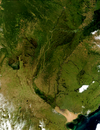
The Río de la Plata basin, more often called the River Plate basin in scholarly writings, sometimes called the Platine basin or Platine region, is the 3,170,000-square-kilometre (1,220,000 sq mi) hydrographical area in South America that drains to the Río de la Plata. It includes areas of southeastern Bolivia, southern and central Brazil, the entire country of Paraguay, most of Uruguay, and northern Argentina. Making up about one fourth of the continent's surface, it is the second largest drainage basin in South America and one of the largest in the world.

The SV Mandalay is a three-masted schooner measuring 163.75 ft (49.91 m) pp, with a wrought iron hull. It was built as the private yacht Hussar (IV), and would later become the research vessel Vema, one of the world's most productive oceanographic research vessels. The ship currently sails as the cruising yacht Mandalay in the Caribbean.
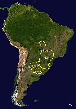
The Paraná Basin is a large cratonic sedimentary basin situated in the central-eastern part of South America. About 75% of its areal distribution occurs in Brazil, from Mato Grosso to Rio Grande do Sul states. The remainder area is distributed in eastern Paraguay, northeastern Argentina and northern Uruguay. The shape of the depression is roughly elliptical and covers an area of about 1,500,000 km2 (580,000 sq mi).
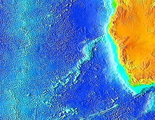
The Walvis Ridge is an aseismic ocean ridge in the southern Atlantic Ocean. More than 3,000 km (1,900 mi) in length, it extends from the Mid-Atlantic Ridge, near Tristan da Cunha and the Gough Islands, to the African coast. The Walvis Ridge is one of few examples of a hotspot seamount chain that links a flood basalt province to an active hotspot. It is also considered one of the most important hotspot tracks because the Tristan Hotspot is one of few primary or deep mantle hotspots.

A contourite is a sedimentary deposit commonly formed on continental rise to lower slope settings, although they may occur anywhere that is below storm wave base. Countourites are produced by thermohaline-induced deepwater bottom currents and may be influenced by wind or tidal forces. The geomorphology of contourite deposits is mainly influenced by the deepwater bottom-current velocity, sediment supply, and seafloor topography.
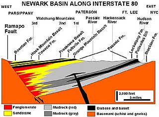
A half-graben is a geological structure bounded by a fault along one side of its boundaries, unlike a full graben where a depressed block of land is bordered by parallel faults.

The Rio Grande Rise, also called the Rio Grande Elevation or Bromley Plateau, is an aseismic ocean ridge in the southern Atlantic Ocean off the coast of Brazil. Together with the Walvis Ridge off Africa, the Rio Grande Rise forms a V-shaped structure of mirrored hotspot tracks or seamount chains across the northern South Atlantic. In 2013, Brazilian scientists announced that they found granite boulders on the Rio Grande Rise and speculated that it could be the remains of a submerged continent, which they called the "Brazilian Atlantis". Other researchers, however, noted that such boulders can end-up on the ocean floor by less speculative means.
The Brazil–Falkland Confluence Zone is a very energetic region of water just off the coast of Argentina and Uruguay where the warm poleward flowing Brazil Current and the cold equatorward flowing Falkland Current converge. The region oscillates latitudinally, but in general the region of confluence occurs between 35 and 45 degrees south latitude and 50 to 70 degrees west longitude. The confluence of these two currents causes a strong thermohaline to exist and causes numerous high energy eddies to form.
Vema Seamount is a seamount in the South Atlantic Ocean. Discovered in 1959 by a ship with the same name, it lies 1,600 kilometres (1,000 mi) from Tristan da Cunha and 1,000 kilometres (620 mi) northwest of Cape Town. The seamount has a flat top at a mean depth of 73 metres which was eroded into the seamount at a time when sea levels were lower; the shallowest point lies at 26 metres depth. The seamount was formed between 15-11 million years ago, possibly by a hotspot.
Madeira Abyssal Plain, also called Madeira Plain, is an abyssal plain situated at the center and deepest part of the Canary Basin. It is a north-northeast to south-southeast elongated basin that almost parallels the Mid-Atlantic Ridge. Its western boundary is marked by a chain of seamounts known as the either Seewarte Seamounts or Atlantis-Great Meteor Seamount Chain. Its eastern boundary is a distinct break of slope that marks the foot of the African Continental Rise. This abyssal plain occupies an area of about 68,000 km2 (26,000 sq mi). Across this basin, slope angles are generally less than 0.01°.
The Uruguay - Buenos Aires Shelf marine ecoregion covers waters offshore of Uruguay, the mouth of the Rio de la Plata), and Buenos Aires Province of Argentina. It has an area of 258,490 square kilometres (99,800 sq mi) and a coastline of 1,300 kilometres (810 mi). Marine biodiversity is very high due to the mixing of currents, the mixing of fresh and salt water, the mixing of temperatures, and the broad, shallow continental shelf. Large amounts of nutrients arrive from the northwest flowing Malvinas Current and from the continental runoff of the Rio de la Plata. Aside from high populations of fish there are colonies of marine mammals, sea turtles, and seabirds.
References
- ↑ Charton, Barbara (2008). The Facts on File dictionary of marine science. Science Dictionaries Series (2nd ed.). Infobase Publishing. p. 22. ISBN 0-8160-6383-4.
- ↑ Rebesco, Michele; Camerlenghi, Angelo (2008). Contourites. Developments in sedimentology. Vol. 60. Elsevier. p. 353. ISBN 0-444-52998-5.
- ↑ Johnson, David A.; Ledbetter, Michael; Burckle, Lloyd H. (1977). "Vema Channel Paleo-Oceanography: Pleistocene Dissolution Cycles and Episodic Bottom Water Flow". Developments in Sedimentology. 23: 1–33. doi:10.1016/S0070-4571(08)70548-X.
40°00′00″S43°00′00″W / 40.0000°S 43.0000°W
| | This article about a specific oceanic location or ocean current is a stub. You can help Wikipedia by expanding it. |