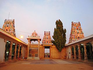
Erode District is a district in the Kongu Nadu region of the state of Tamil Nadu, India. It was the largest district by area in the state before the Formation of Tirupur District and the headquarters of the district is Erode. It is divided into two revenue divisions namely Erode and Gobichettipalayam and further subdivided into 10 taluks. Periyar district was a part of Coimbatore District before its division into two on September 17, 1979 and was renamed as Erode District in 1996.It is consider to be a largest city by area in Tamilnadu covering above 8000 sq.km. As of 2011, the district had a population of 2,251,744 with a sex-ratio of 993 females for every 1,000 males, much above the national average of 929.

Aravakurichi is a panchayat town and a Taluk headquarters in Karur district in the state of Tamil Nadu, India. Aravakurichi is also a taluk. Aravakurichi is well known in Tamil Nadu as a major market for Moringa oleifera vegetable.

Kodumudi is a panchayat town and taluk headquarters of Kodumudi taluk in erode district at state of Tamil Nadu,India. Kodumudi has an average elevation of 144 metres (472 feet). Also kodumudi is an tourism spot. Holy kaveri river and Magudeswarar temple in Kodumudi attracts thousands of pilgrims daily across South India.

Mohanur is a new Taluk in the Namakkal district of the Indian state Tamil Nadu. The Mohanur Panchyat Union includes Mohanur Town, Pettapalayam, Manappalli, Rasipalayam, Kumaripalayam, Sengappalli, Ediyar, Perumandam Palayam, Ariyur, Aniyapuram, and Valayapatti. It is linked to Tiruchirappalli, Salem, Erode, and Karur districts by road.

Mulanur is a panchayat town under in Dharapuram taluk in Tirupur District in the Indian state of Tamil Nadu.

TNPL Kagithapuram is a panchayat town in Karur district in the Indian state of Tamil Nadu.

Vijayamangalam is a census town in Erode district in the Indian state of Tamil Nadu. It is located on National Highway 47 (NH-47) between Perundurai and Perumanallur.

Sivagiri is a panchayat town in Kodumudi Taluk Erode district in the Indian state of Tamil Nadu.

Sendamangalam is a Taluk in the Indian state of Tamil Nadu is situated in Namakkal District.

Unjalur is a panchayat town situated in Erode district in the Indian state of Tamil Nadu. Unjalur is located about 32 kilometres (20 mi) from district head quarters Erode and 8 kilometres (5.0 mi) from Kodumudi, which is known for the Mahudeswarar, Veera Narayana Perumal and Brama Deva temple.
Thamaraipalayam is a village located on the banks of the Cauvery, in Erode district, Tamil Nadu, India.

Lakkapuram or Punjai Lakkapuram is a Village Panchayat located in Erode district, in the Indian state of Tamil Nadu. Lakkapuram village falls under Modakurichi taluk.
Thirukkattuthurai is a small village located in Karur District in the Indian state of Tamil Nadu. It is the first of the three wards of the Thirukkattuthurai village Panchayat. The village is situated on the bank of the river Cauvery. The village Co-operative water pumping station is the first of its kind in Tamil Nadu planned by O.K.Ramaswamy Gounder and inaugurated by K.Kamarajar, Chief Minister of Tamil Nadu in that period. It is about 4.5 km from TNPL Pugalur. The adjacent towns and villages are Aalamarathumeydu, Karapalayam, Nadayanur, Velayuthampalayam, Kattipalayam and Thavittupalayam. The adjacent town Velayuthampalayam have the hill named Pugali Malai/Arunattan Malai, which houses Lord Murugan.
Kalabhavi is a village in Belgaum district in Karnataka, India.

Coimbatore district was one of the districts of the erstwhile Madras Presidency of British India. It covered the areas of the present-day districts of Coimbatore, Erode and Tirupur and the Kollegal taluk of present-day Karnataka. It covered a total area of 20,400 square kilometres (7,860 sq mi) and was sub-divided into 10 taluks. The administrative headquarters was Coimbatore city. Most of Coimbatore's inhabitants were Tamil-speaking but there were also large numbers of Malayalam, Telugu and Kannada speaking people.
Vangal is a village in the Karur district of the Indian state of Tamil Nadu. It is situated 80 km (50 mi) from Tiruchirappalli and 7 miles from Karur town. Vangal is also known as Vangal-Kuppuchipalayam and Vangal Palayur.

Nallathur is a village in Cuddalore district in state of Tamil Nadu, India.

Sivagiri is a panchayat town in Erode district in the Indian state of Tamil Nadu.
State Highway 84 runs in Erode district and Karur district of Tamil Nadu, India. It connects the towns of Erode and Karur.


