| Arkonaplatz | |
|---|---|
 | |
 | |
| Location | Berlin |
| Area | Mitte |
Arkonaplatz is a 1.5-hectare square in Berlin's Mitte district of the same name and is part of the historic Rosenthaler Vorstadt district. It was created in the middle of the 19th century.
| Arkonaplatz | |
|---|---|
| | |
| | |
| Location | Berlin |
| Area | Mitte |
Arkonaplatz is a 1.5-hectare square in Berlin's Mitte district of the same name and is part of the historic Rosenthaler Vorstadt district. It was created in the middle of the 19th century.
Arkonaplatz is bordered by Granseer Strasse to the south, Wolliner Strasse to the east and Ruppiner Strasse to the west. In the north, Arkonaplatz extends to the houses, with house numbers 1-10.
The town square was named after the steep coast of Cape Arkona on the island of Rügen by cabinet decision on 22 November 1875.
Arkona Square was designed and laid out according to the Hobrecht plan as Square C of Department XI and according to the building regulations of 1853. In 1875, it received its name and the expansion together with the neighbouring streets into a residential area began.
Instead of the 1887 design by Hermann Mächtig as an ornamental square, Albert Brodersen added a children's playground to the square in 1918. Later, the magistrate ordered the square to be decorated with paintings. In 1927, a pelican and a seal made of shell limestone by Martin Müller, a penguin and an anglerfish by W. Schade, also made of shell limestone, and for the paddling pool four groups of children made of bronze by Georg Hengstenberg were set up. [1] The square with its surroundings developed into a quarter for poor population groups. During the Second World War, about 1000 of the more than 4000 dwellings at its boundary were destroyed. The apartment buildings destroyed during the war were cleared away and new apartment buildings were built in their place in the 1950s and 1960s.

From the 1970s onwards, the GDR had the square extensively restored or partially modernized, and the areas were redesigned. On the occasion of the extensive redevelopment (then called reconstruction) of the residential area around Arkonaplatz, for example, the section of Swinemünder Strasse that runs across the (present) square was closed to public traffic and integrated into the square. A weekly market has been held here regularly since about 1985. [2]
After the end of the GDR, the square developed into a preferred residential area for young families. Children use the spacious playground here, parents use the restaurants surrounding the square. Unlike fashionable neighbourhoods such as Helmholtzplatz and especially Kollwitzplatz in Prenzlauer Berg, as well as the areas of the Spandauer Vorstadt in Mitte, which are characterized by tourism, the square is considered quieter and has retained much of its original character.

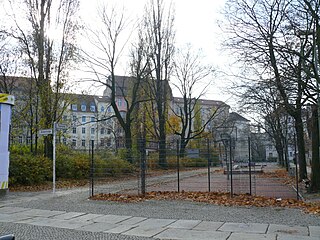
On the west side of the square is one of the oldest school buildings in Berlin (now an elementary school "Grundschule am Arkonaplatz" [3] ), but it is not listed as a historical monument. [4] On the east side is a disused historical toilet building.
Nearby is Zionskirchplatz, Bernauer Strasse, which was once shielded from the Berlin Wall, with the Mauerpark and the streets Kastanienallee and Oderberger Strasse in Prenzlauer Berg, which are characterized by gastronomy and retail.
After the end of the renovation measures in 1984, the entire residential area was handed over to the public in the presence of the GDR's head of state Erich Honecker. On this occasion, for example, 10 window displays were displayed in the former greengrocer's store in the house at Wolliner Strasse, which visibly distorted the reality in the stores of the GDR. For example, pineapples were displayed in the store windows, a fruit that was very rarely offered in the GDR. The day after Honecker's visit, the fruit had disappeared from the store windows. [5]
According to a legend, the idea of founding Berlin's most famous soccer club, Hertha BSC, was conceived in 1892 by the brothers Fritz and Max Lindner and Otto and Willi Lorenz on a bench at Arkonaplatz, where they themselves often played soccer. [6] [7]
Beyond the Rosenthal suburb, the Sunday flea market at Arkonaplatz is well known. [8] [9] A weekly market is held every Friday. [2] The playground is used by locals and visitors alike. [10]

Alexanderplatz is a large public square and transport hub in the central Mitte district of Berlin. The square is named after the Russian Tsar Alexander I and is often referred to simply as Alex, which also denotes the larger neighbourhood stretching from Mollstraße in the north-east to Spandauer Straße and the Rotes Rathaus in the south-west.

Mitte is the first and most central borough of Berlin. The borough consists of six sub-entities: Mitte proper, Gesundbrunnen, Hansaviertel, Moabit, Tiergarten and Wedding.

Pankow is the most populous and the second-largest borough by area of Berlin. In Berlin's 2001 administrative reform it was merged with the former boroughs of Prenzlauer Berg and Weißensee; the resulting borough retained the name Pankow. Pankow was sometimes claimed by the Western Allies to be the capital of the German Democratic Republic, while the German Democratic Republic itself considered East Berlin to be its capital.

Scheunenviertel (help·info) is a neighborhood of Mitte in the centre of Berlin. It is situated to the north of the medieval Altberlin area, east of the Rosenthaler Straße and Hackescher Markt.

Prenzlauer Berg is a locality of Berlin, forming the southerly and most urban district of the borough of Pankow. From its founding in 1920 until 2001, Prenzlauer Berg was a district of Berlin in its own right. However, that year it was incorporated into the greater district of Pankow.

Friedrichshain is a locality of the borough of Friedrichshain-Kreuzberg in Berlin, Germany. From its creation in 1920 until 2001, it was a freestanding city borough. Formerly part of East Berlin, it is adjacent to Mitte, Prenzlauer Berg, Kreuzberg and Lichtenberg.
Wilhelmstrasse is a major thoroughfare in the central Mitte and Kreuzberg districts of Berlin, Germany. Until 1945, it was recognised as the centre of the government, first of the Kingdom of Prussia, later of the unified German Reich, housing in particular the Reich Chancellery and the Foreign Office. The street's name was thus also frequently used as a metonym for overall German governmental administration: much as the term "Whitehall" is often used to signify the British governmental administration as a whole. In English, "the Wilhelmstrasse" usually referred to the German Foreign Office.

Karl-Liebknecht-Straße is a major street in the central Mitte district of the German capital Berlin. It is named after Karl Liebknecht (1871–1919), one of the founders of the Communist Party of Germany. The street connects the Unter den Linden boulevard with the Prenzlauer Allee arterial road leading to the northern city limits. Although part of the street dates back to medieval times, most of the buildings at its side were built in the 1960s, when East Berlin's centre was redesigned as the capital of East Germany.

Leipziger Straße is a major thoroughfare in the central Mitte district of Berlin, capital of Germany. It runs from Leipziger Platz, an octagonal square adjacent to Potsdamer Platz in the west, to Spittelmarkt in the east. Part of the Bundesstraße 1 highway, it is today one of the city's main east–west road links.

Hackescher Markt is a square in the central Mitte locality of Berlin, Germany, situated at the eastern end of Oranienburger Strasse. It is an important transport hub and a starting point for the city's nightlife.

Mauerpark is a public linear park in Berlin's Prenzlauer Berg district. The name translates to "Wall Park", referring to its status as a former part of the Berlin Wall and its Death Strip. The park is located at the border of Prenzlauer Berg and Gesundbrunnen district of former West Berlin.

Gethsemane Church is one of four church buildings of the Lutheran Northern Prenzlauer Berg Evangelical Congregation, within the Evangelical Church of Berlin-Brandenburg-Silesian Upper Lusatia, an umbrella organisation which includes Lutheran, Reformed, and United Protestant Calvinist congregations.

Mitte is a central locality (Ortsteil) of Berlin in the eponymous district (Bezirk) of Mitte. Until 2001, it was itself an autonomous district.

Gesundbrunnen is a locality (Ortsteil) of Berlin in the borough (Bezirk) of Mitte. It was created as a separate entity by the 2001 administrative reform, formerly the eastern half of the former Wedding district and locality. Gesundbrunnen has the highest percentage of non-German residents of any Berlin locality, at 35.1% as of the end of 2008.
The old Berlin Nordbahnhof was a short-lived passenger railway terminus in Berlin, Germany. It was situated in Prenzlauer Berg, close to the borders with Gesundbrunnen, in the area of the "Mauerpark".
Oranienburger Vorstadt is a historic district of Berlin in what is now the northwestern part of Mitte and the adjacent Gesundbrunnen area, in the modern Mitte borough.
The Ackerstraße is a street in Berlin which runs northwest from near the Liesenstraße – Scheringstraße traffic circle in Gesundbrunnen to Invalidenstraße, where it turns south, terminating at the Linienstraße in Mitte.

Kollwitzplatz is a city square in the Berlin district of Prenzlauer Berg, district of Pankow. The square forms the center of the so-called "Kollwitzkiez". It was named, on 7 October 1947, after the German graphic artist and sculptor Käthe Kollwitz, who spent a large part of her life here in the house at Weissenburger Straße No. 25. Until then, it was called Wörther Platz; a name that was given to it when the area was planned for construction in 1875. Indirectly, this name is also a reminder of his husband Karl Kollwitz, who worked here as a physician until 1940 and thus shaped the area around the square independently of his wife. The triangular complex is bordered by Kollwitzstraße, Knaackstraße and Wörther Straße. In total, the square is about 6000 m2 in size.
Spandauer Vorstadt is a historic district in what is now the Mitte district of Berlin, Germany.

Heinrich Wilhelm Krausnick was a German lawyer and Lord Mayor of Berlin in two terms from 1834 until 1848, and again in 1850 until 1862.