Taşucu is a neighbourhood in the municipality and district of Silifke, Mersin Province, Turkey. Its population is 15,184 (2022). Before the 2013 reorganisation, it was a town (belde). It had obtained the status of belde after the local elections in Turkey, 1955.
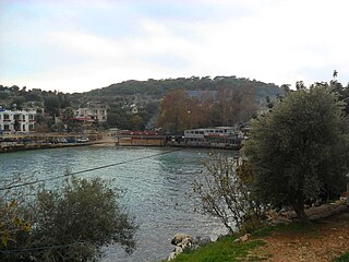
Narlıkuyu is a neighbourhood in the municipality and district of Silifke, Mersin Province, Turkey. Its population is 2,476 (2022). Before the 2013 reorganisation, it was a town (belde).
Yeşilovacık is a neighbourhood in the municipality and district of Silifke, Mersin Province, Turkey. Its population is 3,877 (2022). Before the 2013 reorganisation, it was a town (belde).

Limonlu is a neighbourhood in the municipality and district of Erdemli, Mersin Province, Turkey. Its population is 2,939 (2022). Before the 2013 reorganisation, it was a town (belde).

Uzuncaburç is a neighbourhood in the municipality and district of Silifke, Mersin Province, Turkey. Its population is 878 (2022). Before the 2013 reorganisation, it was a town (belde).
Atayurt is a neighbourhood in the municipality and district of Silifke, Mersin Province, Turkey. Its population is 6,876 (2022). Before the 2013 reorganisation, it was a town (belde).

Atakent is a neighbourhood in the municipality and district of Silifke, Mersin Province, Turkey. Its population is 8,195 (2022). Before the 2013 reorganisation, it was a town (belde).

Akdere is a neighbourhood in the municipality and district of Silifke, Mersin Province, Turkey. Its population is 1,268 (2022). Before the 2013 reorganisation, it was a town (belde).
Burunucu is a neighbourhood in the municipality and district of Silifke, Mersin Province, Turkey. Its population is 865 (2022). The village is situated on the state highway D.400, almost at the midpoint between Silifke and Taşucu, the distance to both being about 5 kilometres (3.1 mi). It is 86 kilometres (53 mi) from Mersin.
Keben is a neighbourhood in the municipality and district of Silifke, Mersin Province. Its population is 557 (2022). Distance to Silifke is 18 kilometres (11 mi) and to Mersin is 105 kilometres (65 mi). It is situated to the north of Turkish state highway D.715 and Göksu River. The village is famous for its main crop, namely pomegranate. This product is now proposed to be officially registered as pomegranate of Keben. Another important product is plum.
Bolacalıkoyuncu is a neighbourhood in the municipality and district of Silifke, Mersin Province, Turkey. Its population is 971 (2022). The village is situated on the state highway D.400. It is almost merged to Taşucu a town to the west. The distance to Silifke is 6 kilometres (3.7 mi) and to Mersin is 91 kilometres (57 mi). The name of the village is composed of two words. Bolacalı refers to a cross bred goat and koyuncu means sheepman. But the village economy depends mostly on fruit and vegetable farming.
Gülümpaşalı is a neighbourhood in the municipality and district of Silifke, Mersin Province, Turkey. Its population is 395 (2022). The village is situated in the coastal plain of Silifke about 3 kilometres (1.9 mi) north of the Mediterranean Sea coast and to the south of Turkish state highway D.400 connecting Mersin to Antalya. The distance to Silifke is 7 kilometres (4.3 mi) and to Mersin is 92 kilometres (57 mi).
Bükdeğirmeni is a neighbourhood in the municipality and district of Silifke, Mersin Province, Turkey. Its population is 295 (2022). It is situated to the east of Göksu River. The distance to Silifke is 10 kilometres (6.2 mi) and to Mersin is 95 kilometres (59 mi). The population is composed of two different stocks. The ancestors of most people are from the now-abandoned nearby village of Multay and they may be of Mongol origin from the 14th century. The ancestors of the second group are animal breeders from Anamur. Major economic activities are farming and animal breeding.
Bahçe is a neighbourhood in the municipality and district of Silifke, Mersin Province, Turkey. Its population is 182 (2022). It is situated in the delta of Göksu River. The distance to Silifke is 6 kilometres (3.7 mi) and to Mersin is 86 kilometres (53 mi).

Hüseyinler is a neighbourhood in the municipality and district of Silifke, Mersin Province, Turkey. Its population is 565 (2022). The village is situated in the peneplane area of Toros Mountains. The distance to Silifke is 30 kilometres (19 mi) and to Mersin is 65 kilometres (40 mi). Hüseyinler is north of Kızkalesi and Adamkayalar The road between Hüseyinler and Kızkalesi is only 5 kilometres (3.1 mi) and the path to Adamkayalar is 2 kilometres (1.2 mi). Main activity of the village is agriculture. The crops include tomato and beans. Export of bay leaf also contribute to village economy.
Demircili is a neighbourhood in the municipality and district of Silifke, Mersin Province, Turkey. Its population is 385 (2022). It is situated on the southern slopes of the Taurus Mountains. The distance to Silifke is 10 kilometres (6.2 mi) and to Mersin is 91 kilometres (57 mi). There are Roman ruins, some of which are situated along the road to the north, mostly mausoleums of wealthy Roman citizens of Seleucia who had summer residences in Demircili, as many Silifke residents still do today. The main economic activity is agriculture. Olives and pistachios are the most pronounced crops.
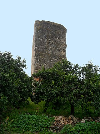
Dikilitaş is a neighbourhood in the municipality and district of Akdeniz, Mersin Province, Turkey. Its population is 1,069 (2022). It takes its name from an ancient Assyrian monument.
Ekşiler is a neighbourhood in the municipality and district of Silifke, Mersin Province, Turkey. Its population is 113 (2022). It is situated in the Göksu River valley. The village is to the north of Göksu River and Turkish state highway D.715. Its distance to Silifke is 10 kilometres (6.2 mi) and to Mersin is 95 kilometres (59 mi). The main economic activities of the village are farming and animal breeding.
Keşlitürkmenli is a neighbourhood in the municipality and district of Silifke, Mersin Province, Turkey. Its population is 327 (2022). It is situated in the Taurus Mountains. Distance to Silifke is 20 kilometres (12 mi) and to Mersin is 85 kilometres (53 mi). The important archaeological site Neopolis is about 8 kilometres (5.0 mi) north of the village. Main economic activity is farming.
Nasrullah is a neighbourhood in the municipality and district of Silifke, Mersin Province, Turkey. Its population is 32 (2022). It is situated in the Taurus Mountains about 7 kilometres (4.3 mi) north of Göksu River valley. Its distance to Silifke is 45 kilometres (28 mi) and to Mersin is 130 kilometres (81 mi). The main economic activity is farming.
