
Canada has a vast geography that occupies much of the continent of North America, sharing a land border with the contiguous United States to the south and the U.S. state of Alaska to the northwest. Canada stretches from the Atlantic Ocean in the east to the Pacific Ocean in the west; to the north lies the Arctic Ocean. Greenland is to the northeast with a shared border on Hans Island. To the southeast Canada shares a maritime boundary with France's overseas collectivity of Saint Pierre and Miquelon, the last vestige of New France. By total area, Canada is the second-largest country in the world, after Russia. By land area alone, however, Canada ranks fourth, the difference being due to it having the world's largest proportion of fresh water lakes. Of Canada's thirteen provinces and territories, only two are landlocked while the other eleven all directly border one of three oceans.

Lake Winnipeg is a very large, relatively shallow 24,514-square-kilometre (9,465 sq mi) lake in North America, in the province of Manitoba, Canada. Its southern end is about 55 kilometres (34 mi) north of the city of Winnipeg. Lake Winnipeg is Canada's sixth-largest freshwater lake and the third-largest freshwater lake contained entirely within Canada, but it is relatively shallow excluding a narrow 36 m (118 ft) deep channel between the northern and southern basins. It is the eleventh-largest freshwater lake on Earth. The lake's east side has pristine boreal forests and rivers that were in 2018 inscribed as Pimachiowin Aki, a UNESCO World Heritage Site. The lake is 416 km (258 mi) from north to south, with remote sandy beaches, large limestone cliffs, and many bat caves in some areas. Manitoba Hydro uses the lake as one of the largest reservoirs in the world. There are many islands, most of them undeveloped.

The Nelson River is a river of north-central North America, in the Canadian province of Manitoba. The river drains Lake Winnipeg and runs 644 kilometres (400 mi) before it ends in Hudson Bay. Its full length is 2,575 kilometres (1,600 mi), it has mean discharge of 2,370 cubic metres per second (84,000 cu ft/s), and has a drainage basin of 1,072,300 square kilometres (414,000 sq mi), of which 180,000 square kilometres (69,000 sq mi) is in the United States.

The District of Keewatin was a territory of Canada and later an administrative district of the Northwest Territories. It was created in 1876 by the Keewatin Act, and originally it covered a large area west of Hudson Bay. In 1905, it became a part of the Northwest Territories and in 1912, its southern parts were adjoined to the provinces of Manitoba and Ontario, leaving the remainder, now called the Keewatin Region, with a population of a few thousand people. On April 1, 1999, the Keewatin Region was formally dissolved, as Nunavut was created from eastern parts of the Northwest Territories, including all of Keewatin.

Gillam is a town on the Nelson River in northern Manitoba, Canada. It is situated between Thompson and Churchill on the Hudson Bay Railway line.
Kississing Lake is a lake in western Manitoba, Canada, approximately 30 kilometres (19 mi) northeast of Flin Flon. The Kississing River drains it northeast into Flatrock Lake on the Churchill River. The community of Sherridon is on its eastern shores, and the Kississing Lake Indian Reserve is on the western side.

The history of post-confederation Canada began on July 1, 1867, when the British North American colonies of Canada, New Brunswick, and Nova Scotia were united to form a single Dominion within the British Empire. Upon Confederation, the United Province of Canada was immediately split into the provinces of Ontario and Quebec. The colonies of Prince Edward Island and British Columbia joined shortly after, and Canada acquired the vast expanse of the continent controlled by the Hudson's Bay Company, which was eventually divided into new territories and provinces. Canada evolved into a fully sovereign state by 1982.

The Nelson River Hydroelectric Project refers to the construction of a series of dams and hydroelectric power plants on the Nelson River in Northern Manitoba, Canada. The project began to take shape in the late 1950s, with the planning and construction of the Kelsey dam and hydroelectric power station, and later was expanded to include the diversion of the upper Churchill River into the Nelson River and the transformation of Lake Winnipeg, the world's 11th largest freshwater lake, into a hydroelectric reservoir. The project is owned and operated by Manitoba Hydro, the electrical utility in the province.
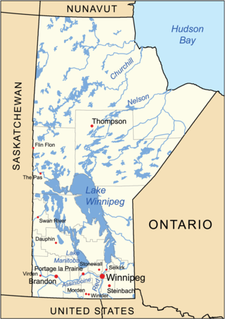
The geography of Manitoba addresses the easternmost of the three prairie Canadian provinces, located in the longitudinal centre of Canada. Manitoba borders on Saskatchewan to the west, Ontario to the east, Nunavut to the north, and the American states of North Dakota and Minnesota to the south. Although the border with Saskatchewan appears straight on large-scale maps, it actually has many right-angle corners that give the appearance of a slanted line. In elevation, Manitoba ranges from sea level on Hudson Bay to 2727 ft (831 m) on top of Baldy Mountain. The northern sixty percent of the province is on the Canadian Shield. The northernmost regions of Manitoba lie permafrost, and a section of tundra bordering Hudson Bay.
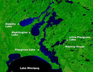
Playgreen Lake or Play Green Lake, is a lake in the province of Manitoba in Canada. The lake covers an area of 657 square kilometres (254 sq mi) and it is a part of the Nelson River watershed. The lake is the ninth largest lake in the province. It is located along the Nelson River some 10 kilometres (6.2 mi) north from the north end of Lake Winnipeg. It was first mapped by noted British surveyor, map-maker, chief fur trader and the explorer Peter Fidler in 1809.
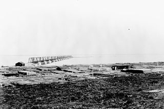
Port Nelson is a ghost town on Hudson Bay, in Manitoba, Canada, at the mouth of the Nelson River. Its peak population in the early 20th century was about 1,000 people. Immediately to the south-southeast is the mouth of the Hayes River and the settlement of York Factory. Some books use 'Port Nelson' to mean the region around the mouths of the two rivers.

The history of Manitoba covers the period from the arrival of Paleo-Indians thousands of years ago to the present day. When European fur traders first travelled to the area present-day Manitoba, they developed trade networks with several First Nations. European fur traders in the area during the late-17th century, with the French under Pierre Gaultier de Varennes, sieur de La Vérendrye set up several trading post forts. In 1670, Britain declared sovereignty over the watershed of Hudson's Bay, known as Rupert's Land; with the Hudson's Bay Company granted a commercial monopoly over the territory.
The Roseau River is a 214-mile-long (344 km) tributary of the Red River of the North, in southern Manitoba in Canada and northwestern Minnesota in the United States. Via the Red River, Lake Winnipeg and the Nelson River, it is part of the watershed of Hudson Bay.

Hudson is an unincorporated place and community in the municipality of Sioux Lookout, Kenora District in northwestern Ontario, Canada. It is located on Lost Lake on the English River in the Nelson River drainage basin.
The Joe River is a 15.2-mile-long (24.5 km) tributary of the Red River of the North that flows through Minnesota in the United States and Manitoba in Canada. Via the Red River, Lake Winnipeg, and the Nelson River, it is part of the Hudson Bay watershed.
Major John Leslie Charles (1892-1992) was Chief Engineer for the Canadian National Railway and consulting engineer for the Canadian National Railway. He worked and published on the subject of railway development in remote or difficult areas. He received numerous awards for his work, including being named an Officer of the Order of Canada.
The Hudson Bay Railway (HBR) is a historic rail line in Manitoba, Canada, to the shore of Hudson Bay. The venture began as a line between Winnipeg in the south and Churchill, and/or Port Nelson, in the north. However, HBR came to describe the final section between The Pas and Churchill.

Lake Athapapuskow is a glacial lake in Manitoba and Saskatchewan, Canada, located 15 km (9.3 mi) southeast of Flin Flon, Manitoba. The lake is in the Hudson Bay drainage basin and is the source of the Goose River.
The Thlewiaza River is a river in Canada. Although some sources define the river as originating out of Nueltin Lake, according to the Canadian Geographical Names Database the river begins at Snyder Lake in northwestern Manitoba. From there the river flows northeast through Kasmere Lake into the southwest end of Nueltin Lake. It exits Nueltin Lake at its northern end in Nunavut and flows 275 kilometres (171 mi) east through Edehon Lake and Ranger Seal Lake before emptying into Hudson Bay. Its drainage basin covers an area of 64,399.6 square kilometres (24,864.8 sq mi).


