
Beverly Hills is a southern suburb of Sydney, in the state of New South Wales, Australia. Beverly Hills is located 15 kilometres southwest of the Sydney central business district and is part of the St George area and is split between the local government areas of the Georges River Council and the City of Canterbury-Bankstown. The postcode is 2209, which it shares with neighbouring Narwee.

Arncliffe is a suburb in southern Sydney, in the state of New South Wales, Australia. Arncliffe is located 11 kilometres south of the Sydney central business district, in the local government area of the Bayside Council.
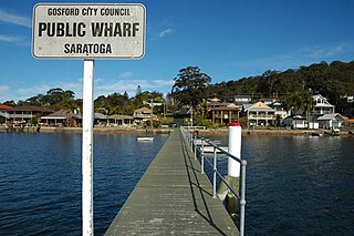
Saratoga is a residential south-eastern village and suburb of the Central Coast region of New South Wales, Australia, located on a peninsula of Brisbane Water and part of the Central Coast Council local government area. The suburb is characterised by its largely settled shoreline, with houses extending up coastal slopes to the base of the tall hills that comprise the core of the peninsula.
Rockdale is a suburb in southern Sydney, in the state of New South Wales, Australia. Rockdale is located 13 kilometres south of the Sydney central business district and is part of the St George area. Rockdale is one of the administrative centres for the local government area of the Bayside Council. Since 1985 Rockdale has been a twinned city with Bitola, in the Republic of Macedonia.
Turrella (;) is a suburb in southern Sydney, in the state of New South Wales, Australia. Turrella is located 10 km south-west of the Sydney central business district on the southern bank of Wolli Creek in the local government area of Bayside Council.

South Granville is a suburb in western Sydney, in the state of New South Wales, Australia. It is located 23 kilometres (14 mi) west of the Sydney central business district, in the local government area of the Cumberland City Council.

Rosehill is a suburb of Sydney, in the state of New South Wales, Australia. Rosehill is located 18 kilometres west of the Sydney central business district in the local government area of the City of Parramatta and is part of the Greater Western Sydney region.

North Parramatta is a suburb on the North Shore of Sydney, in the state of New South Wales, Australia. North Parramatta is 24 kilometres north-west of the Sydney central business district in the local government area of the City of Parramatta.

Kingsgrove is a suburb in Southern Sydney, New South Wales, Australia. Kingsgrove is 13 kilometres (8.1 mi) south-west of the Sydney central business district and lies across the local government areas of the City of Canterbury-Bankstown, Bayside Council and the Georges River Council.

Kyeemagh is a suburb in southern Sydney, in the state of New South Wales, Australia. It is 12 kilometres south of the Sydney central business district, on the western shore of Botany Bay. Kyeemagh is in the local government area of the Bayside Council and is part of the St George area.

Wolli Creek is a suburb in southern Sydney, in the state of New South Wales, Australia. It sits beside the Wolli Creek and Cooks River waterways. Wolli Creek is situated between the suburbs of Arncliffe and Tempe, 10 kilometres south of the Sydney central business district and is part of the St George area. Wolli Creek is in the local government area of Bayside Council.

Wolli Creek is an urban watercourse of the Cooks River catchment located in the southern suburbs of Sydney, in New South Wales, Australia.

Banksia is a suburb in southern Sydney, in the state of New South Wales, Australia. Banksia is located 12 kilometres south of the Sydney central business district, in the local government area of the Bayside Council and is part of the St George area.

Bexley is a suburb in southern Sydney, in the state of New South Wales, Australia. Bexley is located 14 kilometres (8.7 mi) south-west of the Sydney central business district, in the local government area of the Bayside Council and is part of the St George area.

Bardwell Valley is a suburb in southern Sydney, in the state of New South Wales, Australia. Bardwell Valley is located approximately 12 kilometres south-west of the Sydney central business district, in the local government area of the Bayside Council and is part of the St George area.
Mannering Park is a suburb of the Central Coast region of New South Wales, Australia. It is part of the Central Coast Council local government area. It was formerly called Vales Point.

Phillip Street is a street in the central business district of Sydney in New South Wales, Australia. While the street runs from King Street in the south to Circular Quay in the north, the present street is effectively in two sections, separated by Chifley Square. Other cross streets include Martin Place, Bridge Street, and Bent Street. It is the hotspot of Sydney's legal elite.
Earl Park is the name of a former sports field in the Sydney suburb of Arncliffe. From 1925 to 1939 it was the site of New South Wales Rugby Football League Premiership club, St. George's home ground and headquarters. The ground was provided by a club benefactor named Lancelot Lewis Earl (1862-1938). Lancelot Earl owned and lived on the Earl Park estate until his death in 1938. The estate was sold in 1940 and a factory was built on the site.

Mosman High School, is a school located in Mosman, a suburb of Sydney, Australia, on Military Road. It is a co-educational high school operated by the New South Wales Department of Education with students from years 7 to 12. The school was established in 1961 and is one of the few state schools in NSW that has no school uniform.

Rainbow Street Public School is a public school located in Randwick, New South Wales, Australia operated by the New South Wales Department of Education. The school has 480 students and 34 staff, and is in close proximity to the University of NSW, Prince of Wales Hospital and the Randwick Army Barracks. The school has a close liaison with Randwick Boys and Girls High Schools, as well as Rainbow Street Childcare Centre.


