
County Fermanagh is one of the thirty-two counties of Ireland, one of the nine counties of Ulster and one of six counties of Northern Ireland.

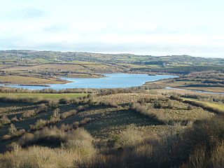
Lough Erne is the name of two connected lakes in County Fermanagh, Northern Ireland. It is the second-biggest lake system in Northern Ireland and Ulster, and the fourth biggest in Ireland. The lakes are widened sections of the River Erne, which flows north and then curves west into the Atlantic. The smaller southern lake is called the Upper Lough as it is higher up the river. The bigger northern lake is called the Lower Lough or Broad Lough. The town of Enniskillen lies on the short stretch of river between the lakes. The lake has more than 150 islands, along with many coves and inlets. The River Erne is 80 miles (129 km) long and drains an area of about 1,680 square miles (4,350 km2).
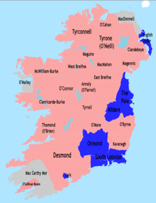
The Nine Years' War, sometimes called Tyrone's Rebellion, took place in Ireland from 1593 to 1603. It was fought between an Irish confederation—led mainly by Hugh O'Neill of Tyrone and Hugh Roe O'Donnell of Tyrconnell—against English rule in Ireland, and was a response to the ongoing Tudor conquest of Ireland. The war began in Ulster and northern Connacht, but eventually engulfed the entire island. The Irish alliance won numerous victories against the English forces in Ireland, such as the Battle of Clontibret (1595) and the Battle of the Yellow Ford (1598), but the English won a pivotal victory against the alliance and their Spanish allies in the siege of Kinsale (1601–02). The war ended with the Treaty of Mellifont (1603). Many of the defeated northern lords left Ireland to seek support for a new uprising in the Flight of the Earls (1607), never to return. This marked the end of Gaelic Ireland and led to the Plantation of Ulster.

The River Erne in the northwest of the island of Ireland, is the second-longest river in Ulster, flowing through Northern Ireland and the Republic of Ireland, and forming part of their border.
Aodh Mag Uidhir, anglicised as Hugh Maguire was Chief of the Name of the Irish clan Maguire and Lord of Fermanagh during the reign of Elizabeth I. He died in battle resisting the Tudor conquest of Ireland as part of the Nine Years War.

Belcoo ( is a small village and townland in County Fermanagh, Northern Ireland, 10 miles from Enniskillen. It is on the County Fermanagh/County Cavan border beside the village of Blacklion in the Republic of Ireland. It had a population of 540 in the 2011 Census. It is situated within the Fermanagh and Omagh District.

Blacklion is a border village in west County Cavan, Ireland. It is situated on the N16 national primary road, just across the border from the County Fermanagh village of Belcoo.

Lough MacNean is a large freshwater lake on the border between Northern Ireland and the Republic of Ireland.

The Colebrooke River is a river in County Fermanagh, Northern Ireland. Its source is in the Sliabh Beagh mountains where it is known as the Many Burns.
The Bhotha Mhuintir Uí Fhialáin were an Irish tribe that lived in the area now known as Boho in County Fermanagh, Northern Ireland.
The Sillees River is located in south-western County Fermanagh. Its origins lie in Lough Ahork, which is located in Lough Navar Forest. From here it continues through Correl Glen, Derrygonnelly and the Boho countryside, passing through both Carran and Ross Loughs where it ends in Lower Lough Erne.
Crom Castle is a country house on the shores of Upper Lough Erne in County Fermanagh, Northern Ireland, the seat of the Earls Erne. Standing within the 1,900-acre (7.7 km2) Crom Estate, and within a formal garden, the castle is built in stone. A central battlemented tower includes the main entrance, and there are also smaller towers to one side. It stands apart from the ruins of Old Crom Castle, of which two towers, some walls, and a ha-ha survive, and near them two ancient yew trees, believed to be at least 800 years old.

Lurg is a barony situated in the north of County Fermanagh, Northern Ireland. To its south lies Lower Lough Erne, and it is bordered by four other baronies in Northern Ireland: Magheraboy to the south; Tirkennedy to the south-east; Omagh West to the north; and Omagh East to the east. It also borders to the west the barony of Tirhugh in the Republic of Ireland.
The Cenél nEógain or Kinel-Owen are a branch of the Northern Uí Néill, who claim descent from Eógan mac Néill, son of Niall of the Nine Hostages. Originally their power-base was in Inishowen, with their capital at Ailech, in modern-day County Donegal in what is now the west of Ulster. Under pressure from the Cenél Conaill, they gradually spread their influence eastwards into modern counties Tyrone and Londonderry, pushing aside the Cruithin east of the River Bann, and encroaching on the Airgiallan tribes west of Lough Neagh. By the 11th century their power-base had moved from Ailech to Tullyhogue outside Cookstown, County Tyrone. By the 12th century the Cenél Conaill conquered Inishowen; however, it mattered little to the Cenél nEóghain as they had established a powerful over-kingdom in the east that had become known as Tír Eoghain, or the "Land of Owen", preserved in the modern-day name of County Tyrone.
Sir Cormac MacBaron O'Neill (d.1613) was an Irish soldier and landowner of the Elizabethan and early Stuart eras. He was part of the O'Neill dynasty, one of the most prominent Gaelic families in Ireland.

The siege of Enniskillen took place at Enniskillen in Fermanagh, present day Northern Ireland, in 1594 and 1595, during the Nine Years' War. In February 1594, the English had captured Enniskillen Castle from the Irish after a waterborne assault and massacred the defenders after they surrendered. From May 1594, an Irish army under Hugh Maguire and Cormac MacBaron O'Neill besieged the English garrison in the castle, and in August they defeated an English relief force. A second relief force was allowed to resupply the garrison, but the castle remained cut off. Eventually, in May 1595, the English garrison surrendered to the Irish and were then massacred.

The Battle of the Ford of the Biscuits took place in Fermanagh, Ireland on 7 August 1594, during the Nine Years' War. A column of almost 650 English troops led by Sir Henry Duke was ambushed and defeated by a Gaelic Irish force under Hugh Maguire and Cormac MacBaron O'Neill at the Arney River. The English column had been sent to relieve and resupply Enniskillen Castle, which had been under siege by the Irish since May. The English suffered at least 56 killed and 69 wounded, and were forced to make a hasty retreat.
The Battle of Belleek, also known as the Battle of the Erne Fords, was fought on the River Erne near Belleek in Fermanagh, Ireland, on 10 October 1593. It was part of the buildup to the Nine Years' War. The battle was fought between a Gaelic Irish army under Hugh Maguire, lord of Fermanagh—who had begun a revolt against the English—and an English Crown expeditionary force under Sir Henry Bagenal, supported by Hugh O'Neill, Earl of Tyrone. Maguire's force was defeated, but the bulk of his army was unscathed. Hugh O'Neill would later join Maguire in war against the English.
