Related Research Articles

St. Louis County is a county located in the Arrowhead Region of the U.S. state of Minnesota. As of the 2020 census, the population was 200,231. Its county seat is Duluth. It is the largest county in Minnesota by land area, and the largest in the United States by total area east of the Mississippi River. St. Louis County is included in the Duluth, MN–Superior, WI Metropolitan Statistical Area.

Itasca County is a county located in the Iron Range region of the U.S. state of Minnesota. As of the 2020 census, the population was 45,014. Its county seat is Grand Rapids. The county is named after Lake Itasca, which is in turn a shortened version of the Latin words veritas caput, meaning 'truth' and 'head', a reference to the source of the Mississippi River. Portions of the Bois Forte and Leech Lake Indian reservations are in the county.

Cook County is the easternmost county in the U.S. state of Minnesota. As of the 2020 census, the population was 5,600, making it Minnesota's seventh-least populous county. Its county seat is Grand Marais. The Grand Portage Indian Reservation is in the county.

Carlton County is a county in the State of Minnesota, formed in 1857. As of the 2020 census, the population was 36,207. Its county seat is Carlton. Part of the Fond du Lac Indian Reservation lies in northeastern Carlton County.

Lake Alfred is a city in Polk County, Florida, United States. It is part of the Lakeland–Winter Haven Metropolitan Statistical Area. The population was approximately 6,374 at the 2020 US census.

Trout Lake Township is located in north central Minnesota in Itasca County, United States. It is bordered by the City of Coleraine to the west and north, City of Bovey on the north, an unorganized township on the east, and Blackberry Township to the south. Town government was adopted on March 6, 1894. The population was 1,056 at the 2020 census.

Pine City is a city in and the county seat of Pine County, in east central Minnesota, United States. The population was 3,130 at the 2020 census. Part of the city is on the Mille Lacs Indian Reservation. Founded as a railway town, it soon became a logging community and the surrounding lakes made it a resort town. Today, it is in part as a commuter town for people working in the Minneapolis–Saint Paul metropolitan area.

Ely is a city in St. Louis County, Minnesota, United States. The population was 3,268 at the 2020 census.

The Iron Range is collectively or individually a number of elongated iron-ore mining districts around Lake Superior in the United States and Canada. Much of the ore-bearing region lies alongside the range of granite hills formed by the Giants Range batholith. These cherty iron ore deposits are Precambrian in the Vermilion Range and middle Precambrian in the Mesabi and Cuyuna ranges, all in Minnesota. The Gogebic Range in Wisconsin and the Marquette Iron Range and Menominee Range in Michigan have similar characteristics and are of similar age. Natural ores and concentrates were produced from 1848 until the mid-1950s, when taconites and jaspers were concentrated and pelletized, and started to become the major source of iron production.
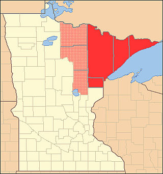
The Arrowhead Region is located in the northeastern part of the U.S. state of Minnesota, so called because of its pointed shape. The predominantly rural region encompasses 10,635.26 square miles (27,545.2 km2) of land area and includes Carlton, Cook, Lake and Saint Louis counties. Its population at the 2000 census was 248,425 residents. The region is loosely defined, and Aitkin, Itasca, and Koochiching counties are sometimes considered as part of the region, increasing the land area to 18,221.97 square miles (47,194.7 km2) and the population to 322,073 residents. Primary industries in the region include tourism and iron mining.
Transportation in the U.S. State of Minnesota consists of a complex network of roadways, railways, waterways and airports. The transportation system is generally overseen by the Minnesota Department of Transportation, a cabinet-level agency of the state government. Additionally, regional governments such as the Metropolitan Council have authority over regional planning for the transportation system and local governments such as cities and counties oversee the local transportation network.
Minnesota's 8th congressional district covers the northeastern part of Minnesota. It is anchored by Duluth, the state's fifth-largest city. It also includes most of the Mesabi & Vermilion iron ranges, and the Boundary Waters Canoe Area in the Superior National Forest. The district is best known for its mining, agriculture, tourism, and shipping industries.
An arrowhead is the point of an arrow.
Fond du Lac Tribal and Community College (FDLTCC) is a public tribal land-grant community college in Cloquet, Minnesota. FDLTCC is located within the Twin Ports area of Duluth, Minnesota and Superior, Wisconsin in northeastern Minnesota. The college is a member of Minnesota State, the American Indian Higher Education Consortium, and the World Indigenous Nations Higher Education Consortium. FDLTCC was Minnesota's first tribal college. FDLTCC is the only college in the nation both established as a tribal college under federal law and operating as part of a state-funded higher education system.

The Duluth Public Library is a library in downtown Duluth, Minnesota. It is a part of the Arrowhead Library System and serves a population of 86,319.
The Taconite State Trail extends 165 miles from Grand Rapids, Minnesota to Ely, Minnesota and intersects the Arrowhead State Trail west of Lake Vermilion. On the Grand Rapids end, the trail is paved for the first 6 miles for in-line skating and biking. The rest of the trail is natural surface used primarily in the winter months for snowmobiling. In the summer, several areas contain standing water, but some areas are suitable for horseback riding, hiking, and mountain biking

The Grand Portage State Forest is a state forest located near the community of Hovland in Cook County, in extreme northeastern Minnesota. The forest encloses Judge C. R. Magney State Park, Swamp River Wildlife Management Area, Hovland Woods Scientific and Natural Area, and Spring Beauty Hardwoods Scientific and Natural Area. It borders the Grand Portage Indian Reservation to the east, the Superior National Forest to the west, and Ontario to the north. The forest is named after the Grand Portage, a historic trade route between the Great Lakes and the Northwest.
The Arrowhead Library System (ALS) was a library system consisting of seven public libraries and several academic/school library affiliate members, all serving Rock County, Wisconsin. The headquarters of the library system was located on the lower level of the Milton Public Library in Milton, Wisconsin. In 2023, Arrowhead Library System merged with the Lakeshores Library System to form the Prairie Lakes Library System.
Regional Development Commissions are regional governments in the U.S. state of Minnesota, made up of a board of local elected officials from counties, cities, schools boards, public interest groups and transit systems that provide cooperation and coordination on broad regional issues. The Regional Development Commissions, commonly abbreviated as RDC, were established by state law in 1969 to provide a variety of governmental assistance to local governments. They are a type of regional planning organization that have responsibility to provide technical assistance to a broad multi-county area of the state, and their functions are similar to the metropolitan planning organization in urbanized areas. As their intent was to support local governments, they frequently provide a coordinating role and generally do not exercise any type of binding authority over local matters.
Kansas City, Kansas Public Library (KCKPL) is the public library system of Kansas City, Kansas, headquartered in the Main Library. The library serves Wyandotte County, Kansas. It is governed by the Board of Education of Kansas City Kansas Public Schools and reports to the Wyandotte County Library Board
References
- ↑ "MNLINK Participating Libraries | MNLINK". mnlink.org. Retrieved 2023-11-25.
- ↑ "MINITEX Delivery Map". Archived from the original on 2012-09-19. Retrieved 2012-11-04.
- 1 2 2008 Minnesota Public Library Statistics. Roseville: Minnesota Department of Education, 2009.
- ↑ Multitype Library Systems, State Library Services, Minnesota Department of Education
- ↑ Regional Library Systems, State Library Services, Minnesota Department of Education
- ↑ About the Arrowhead Library System Archived September 6, 2012, at the Wayback Machine
- ↑ Arrowhead Library System Legacy Grant:SFY 2010-2011
47°31′3″N92°35′34″W / 47.51750°N 92.59278°W
| International | |
|---|---|
| National | |