Moorpark is a city in Ventura County in Southern California. Moorpark was founded in 1900 when the application for the Moorpark Post Office was approved and Inocencio C. Villegas was named Moorpark's first postmaster on August 8 of that year. The townsite of Moorpark was owned and surveyed by Robert W. Poindexter and his wife, Madeline. As of 2006, Moorpark was one of the fastest-growing cities in Ventura County. The town grew from just over 4,000 citizens in 1980 to over 25,000 citizens by 1990. The population was 34,421 at the 2010 census, up from 31,415 at the 2000 census.
The Arroyo Seco Parkway, also known as the Pasadena Freeway, is the first freeway in the Western United States. It connects Los Angeles with Pasadena alongside the Arroyo Seco seasonal river. It is notable not only for being the first, mostly opened in 1940, but for representing the transitional phase between early parkways and modern freeways. It conformed to modern standards when it was built, but is now regarded as a narrow, outdated roadway. A 1953 extension brought the south end to the Four Level Interchange in downtown Los Angeles and a connection with the rest of the freeway system.
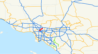
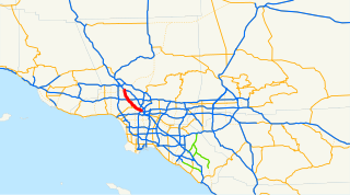
Route 110, consisting of State Route 110 and Interstate 110 (I-110), is a state highway in the Los Angeles metropolitan area of the U.S. state of California, built to freeway standards. The entire route connects San Pedro and the Port of Los Angeles with Downtown Los Angeles and Pasadena. The southern segment from San Pedro to Interstate 10 in downtown Los Angeles is signed as I-110, while the northern segment to Pasadena is signed as SR 110. The entire length of I-110, as well as SR 110 south of the Four Level Interchange with US 101, is the Harbor Freeway, and SR 110 north from US 101 to Pasadena is the historic Arroyo Seco Parkway, the first freeway in the western United States. I-110 is one of two 3-digit interstate designations to appear on opposite coasts; I-280 in California and New Jersey is the other.
The Hollywood Freeway is one of the principal freeways of Los Angeles, California and one of the busiest in the United States. It is the principal route through the Cahuenga Pass, the primary shortcut between the Los Angeles Basin and the San Fernando Valley. It is considered one of the most important freeways in the history of Los Angeles and instrumental in the development of the San Fernando Valley. It is the second oldest freeway in Los Angeles. From its southern end at the Four Level Interchange to its intersection with the Ventura Freeway in the southeastern San Fernando Valley, it is signed as part of U.S. Route 101. It is then signed as State Route 170 north to its terminus at the Golden State Freeway.

The Ventura Freeway is a freeway in southern California, United States, running from the Santa Barbara/Ventura county line to Pasadena in Los Angeles County. It is the principal east-west route through Ventura County and in the southern San Fernando Valley in Los Angeles County. From the Santa Barbara County line to its intersection with the Hollywood Freeway in the southeastern San Fernando Valley in Los Angeles, it is signed as U.S. Route 101, which was built in the late 1950s and opened on April 5, 1960. East of the Hollywood Freeway intersection, it is signed as State Route 134 which was built by 1971. The entire Ventura Freeway is not built to freeway standards, however; the segment that runs through the coastal communities of La Conchita and Mussel Shoals in western Ventura County still remains an expressway.

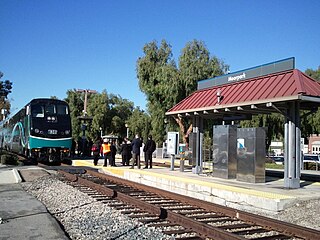
The Metrolink Ventura County Line is a commuter rail line serving Ventura County and the San Fernando Valley in Los Angeles County and the City of Los Angeles, in the Southern California system. The line is the successor of the short lived CalTrain commuter rail line.

Colorado Boulevard is a major east–west street in Southern California. It runs from Griffith Park in Los Angeles east through Glendale, the Eagle Rock section of Los Angeles, Pasadena, and Arcadia, ending in Monrovia. The full route was once various state highways but is now locally maintained in favor of the parallel Ventura Freeway (CA-134) and Foothill Freeway (I-210).

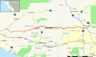
State Route 126 is a highway in Ventura and Los Angeles counties, California. The route runs from U.S. Route 101 in Ventura to Interstate 5 in Santa Clarita through the Santa Clara River Valley. The highway is an important connector highway in Ventura County, and serves as an alternate route into the Santa Clarita and San Fernando valleys, the High Desert of Antelope Valley, and Los Angeles.
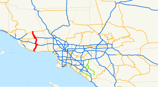
State Route 23 is a state highway which runs roughly from Fillmore to Malibu.

The Southern California freeways are a vast network of interconnected freeways in the megaregion of Southern California, serving a population of 23 million people. The Master Plan of Metropolitan Los Angeles Freeways was adopted by the Regional Planning Commission in 1947 and construction began in the early 1950s. The plan hit opposition and funding limitations in the 1970s, and by 2004, only some 61% of the original planned network had been completed.
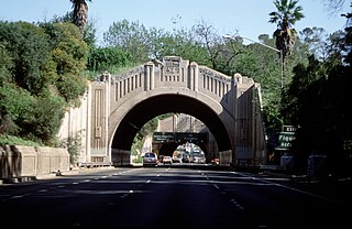
The Figueroa Street Tunnels are a set of four four-lane tunnels that carry northbound traffic on State Route 110 through Elysian Park in Los Angeles, California, United States. From south to north, the four tunnels measure 755, 461, 130, and 405 feet in length, 46.5 feet in width, and 28.3 ft in height. The north three tunnels opened in 1931 as a bypass to a section of North Broadway; the southernmost opened in 1935, connecting to Figueroa Street downtown. In 1937, a viaduct, known as the Figueroa Street Viaduct, was constructed to the north of the tunnels, dedicating the tunnels to 4 lanes of eastward traffic and the viaduct to 4 lanes of westward traffic once the viaduct was opened in 1943. Ever since the opening of the tunnels, connections have been added to the street, most notably in 1940 to the Arroyo Seco Parkway and in 1953 to the Four Level Interchange.

San Fernando Road is a major street in the City of Los Angeles and Los Angeles County. Within the Burbank city limits it is signed as San Fernando Boulevard, and north of Newhall Pass it is signed as The Old Road. It was previously designated as Business Loop 5 in the 1970s.
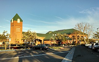
The Oxnard Transit Center, originally known as the Oxnard Transportation Center, is an intermodal transit center in historic downtown Oxnard, California. As a transit hub, the station serves Amtrak and Metrolink trains as well as local and regional buses. Amtrak's Pacific Surfliner from San Luis Obispo to San Diego, Amtrak's Coast Starlight from Los Angeles to Seattle, Washington, and Metrolink's Ventura County Line from Los Angeles Union Station to East Ventura stop here. Ten Pacific Surfliner trains serve the station daily, and six Metrolink trains serve the station each weekday. The Coast Starlight operates one train daily in each direction.
VCTC Intercity is a public transit agency providing bus service in Ventura County, California. It provides an intercity bus service between the cities of Ventura, Oxnard, Camarillo, Thousand Oaks, Moorpark, Santa Paula, and Fillmore in Ventura County, and to communities in neighboring Los Angeles and Santa Barbara counties. The agency is part of the Ventura County Transportation Commission, a governmental body that oversees transportation planning and funding in Ventura County.
The transportation system of Greater Los Angeles includes 7 commuter rail lines, amtrak service, a subway system within the city of Los Angeles, and numerous highways. Los Angeles is integrated into the Interstate Highway System by Interstate 5, Interstate 10, and Interstate 15, along with numerous auxiliary highways and state routes. Bus service is also included locally within the area by numerous local government agencies. Subways and light commuter rail lines are present within Los Angeles proper, allowing mass transportation within the city. Commuter railroads are run by Metrolink. AMTRAK has numerous railroad lines that connect Los Angeles to the rest of the country.

Simi Valley is a synclinal valley in Southern California in the United States. It is an enclosed or hidden valley surrounded by mountains and hills. It is connected to the San Fernando Valley to the east by the Santa Susana Pass and the 118 freeway, and in the west the narrows of the Arroyo Simi and the Reagan Freeway connect to Moorpark and Ventura, California. The relatively flat bottom of the valley contains soils formed from shales, sandstones, and conglomerates eroded from the surrounding hills of the Santa Susana Mountains to the north, which separate Simi Valley from the Santa Clara River Valley, and the Simi Hills.

Tierra Rejada Park is a 150-acre park located in the northern Simi Hills foothills, in southwestern Simi Valley city near Moorpark, in Ventura County, California.
Calleguas Creek is the terminus of a river system in Ventura County, California. It drains the Calleguas Creek Watershed, an area 30 miles long and 14 miles wide, which includes Simi Valley, Moorpark, Camarillo and a large portion of Thousand Oaks. Tributaries include Arroyo Simi, Arroyo Santa Rosa, Revolon Slough and Arroyo Conejo. It discharges into the Pacific Ocean, the Santa Barbara Channel, at Mugu Lagoon on Naval Base Ventura County, just north of Point Mugu, where the Santa Monica Mountains meet the ocean, marking the southern/eastern boundary of the Oxnard Plain.