
Jackson County is located in the U.S. state of Michigan. The population of the county was 160,366 as of the 2020 Census. Its seat of government is the city of Jackson. The county was set off in 1829 and organized in 1832. It is named for U.S. President Andrew Jackson and considered to be one of Michigan's "Cabinet counties", named for members of Jackson's Cabinet.
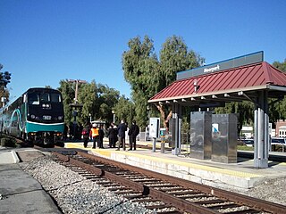
Moorpark is a city in Ventura County in Southern California. Moorpark was founded in 1900. The town grew from just over 4,000 citizens in 1980 to over 25,000 by 1990. As of 2006, Moorpark was one of the fastest-growing cities in Ventura County. The population was 34,421 at the 2010 census, up from 31,415 at the 2000 census.

The Conejo Valley is a region spanning both southeastern Ventura County and northwestern Los Angeles County in Southern California, United States. It is located in the northwestern part of the Greater Los Angeles Area.
Newbury Park is a populated place and town in Ventura County, California, United States. Most of it lies within the western Thousand Oaks city limits, while unincorporated areas include Casa Conejo and Ventu Park. The town is located in Southern California around 8 miles (13 km) from the Pacific Ocean and has a mild year-round climate, scenic mountains, and environmental preservation. About 28,000 residents of Thousand Oaks reside in Newbury Park.

The Arroyo Seco, meaning "dry stream" in Spanish, is a 24.9-mile-long (40.1 km) seasonal river, canyon, watershed, and cultural area in Los Angeles County, California. The area was explored by Gaspar de Portolà who named the stream Arroyo Seco as this canyon had the least water of any he had seen. During this exploration he met the Chief Hahamog-na (Hahamonga) of the Tongva Indians.
Buccaneer State Park is a public recreation area in the U.S. state of Mississippi. The state park is located off U.S. Highway 90 and Beach Boulevard, straddling the line between Waveland and Clermont Harbor. The park sits on the Gulf of Mexico and was entirely rebuilt after all its buildings were destroyed by Hurricane Katrina in 2005.
Taconic State Park is located in Columbia and Dutchess County, New York abutting Massachusetts and Connecticut within the Taconic Mountains. The state park is located off New York State Route 344 south of Interstate 90 and 110 miles (180 km) north of New York City. It features camping, hiking, bicycling, hunting, cross county skiing and other recreational opportunities.

Three Rivers Park District is a special park district serving the suburban areas of the Twin Cities including suburban Hennepin, Carver, Dakota, Scott, and Ramsey counties. Three Rivers's mission is "To promote environmental stewardship through recreation and education in a natural resources-based park system." Three Rivers operates twenty parks and ten regional trails, with at least two more regional trails planned. Nearly seven million people visit Three Rivers facilities each year. It has over 27,000 acres (11,000 ha) of parks and trails.

Eaton Canyon is a major canyon beginning at the Eaton Saddle near Mount Markham and San Gabriel Peak in the San Gabriel Mountains in the Angeles National Forest, United States. Its drainage flows into the Rio Hondo river and then into the Los Angeles River. It is named after Judge Benjamin S. Eaton, who lived in the Fair Oaks Ranch House in 1865 not far from Eaton Creek.

Placerita Canyon State Park is a California State Park located on the north slope of the western San Gabriel Mountains, in an unincorporated rural area of Los Angeles County, near the city of Santa Clarita. The park hosts a variety of historic and natural sites, as well as serving as a trailhead for several hiking trails leading into the San Gabriel Mountains.
Arroyo Sequit is a waterway that runs for about three miles in Ventura County and Los Angeles County in California, United States. Ventura and Los Angeles counties and drains into the Pacific Ocean. The Arroyo Sequit East Fork rises in Los Angeles County, 2 miles (3.2 km) southeast of Triunfo Pass and flows in general southwestward. The West Fork rises in Triunfo Pass two miles above the confluence and flows east of south. Below the forks the course of the creek is west of south to the point at which it enters the Pacific.

The Palos Verdes Peninsula Land Conservancy (PVPLC) is a non-profit organization that is based on the Palos Verdes Peninsula in southwestern Los Angeles County, California.

The Hayward Area Recreation and Park District (H.A.R.D.) is the park management agency for most of the parks in the city of Hayward, California. It was created in 1944 and is an independent special district under California law. H.A.R.D. is the largest recreation district in California. It also manages parks in the bordering unincorporated communities of Castro Valley, San Lorenzo, Fairview, Ashland and Cherryland. It manages the park grounds for numerous schools in the region. Events and classes are scheduled and listed in a quarterly brochure. The parks' 2021 budget is $24,306,495.
Santa Rosa Valley is a rural unincorporated community, named after the eponymous valley in which it lies, located in Ventura County, California, United States. For statistical purposes, the United States Census Bureau has defined Santa Rosa Valley as a census-designated place (CDP). The census definition of the area may not precisely correspond to local understanding of the area with the same name. The 2010 United States census reported Santa Rosa Valley's population was 3,334. Santa Rosa Valley sits at an elevation of 433 feet (132 m).
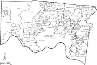
Great Parks of Hamilton County is the park district of Hamilton County, Ohio, United States. It was established in 1930, opening its first park, Sharon Woods, in 1932. It was known as the Hamilton County Park District until 2014. The park system includes 18 parks and 4 conservation areas. It is governed by a board of park commissioners. Park headquarters are located in the second largest park in the system, Winton Woods. The county park system also coordinates with the Cincinnati Park Board.

Wildwood Regional Park is a suburban regional park in the western Simi Hills and Conejo Valley, in Ventura County, California. It is located in western Thousand Oaks, northern Newbury Park, and southern Moorpark.

Rancho Conejo Playfields is a 13 acres (5.3 ha) multi-use community park in Newbury Park, California, adjacent to Conejo Canyons Open Space and the Arroyo Conejo Nature Preserve which includes 302 acres (122 ha) of public open-space land and numerous trails in the western Simi Hills.

Walnut Grove Park is a 6.5 acre community park in Newbury Park, California, United States, situated immediately south of the U.S. 101 Ventura Freeway on Newbury Road. Named for its many walnut trees, the park land was acquired in 1981 and ultimately developed into a community park in 1994. It contains a playground, an outdoor handball court, three BBQ grills, basketball courts, numerous picnic tables, trails, and open-space. It is operated by the Conejo Recreation & Park District (CRPD), and it is adjacent to the Walnut Grove Equestrian Center and its 14 acres of trails, horse arenas, stalls, picnic tables, and various trails for hikers and equestrians. The park is relatively close to the Arroyo Conejo Open Space and its many trails leading for instance to Wildwood Regional Park, which is accessible from its closest trailhead between 507 Kalinda Pl. and 504 Paseo Grande on West Hillcrest Drive. Walnut Grove Park is located along a smaller offspring from the Arroyo Conejo, and is one of only three off-leash dog parks in the Conejo Valley.

The Conejo Canyons Open Space consists of 1,628 acres (659 ha) of open-space areas in northernmost Newbury Park, Ventura County, California. It consists of deeply eroded canyons, numerous ridgelines and plateaus in the northwestern portion of the Conejo Valley. The area consists of diverse natural features such as deep canyons with perennial streams, prominent ridgelines, volcanic mountains, and a variety of natural habitats. While some of the flora includes chaparral, riparian habitats, oak woodlands and coastal sage, fauna includes mountain lions, coyotes, mule deer, and bobcats.

Arroyo Conejo Open Space is a 302-acre (122 ha) open space reserve in the western Simi Hills in northern Newbury Park, Ventura County, California. Most of it is part of the 250-acre (100 ha) Arroyo Conejo Nature Preserve.
